Lincoln County, South Dakota
 Lincoln County Courthouse |
|
| administration | |
|---|---|
| US state : | South Dakota |
| Administrative headquarters : | Canton |
| Address of the administrative headquarters: |
Lincoln County Courthouse 100 East Fifth Street Canton, SD 57013-1798 |
| Foundation : | 1862 |
| Area code : | 001 605 |
| Demographics | |
| Residents : | 44,828 (2010) |
| Population density : | 29.9 inhabitants / km 2 |
| geography | |
| Total area : | 1499 km² |
| Water surface : | 2 km² |
| map | |
| Website : www.lincolncountysd.org | |
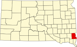
Lincoln County is a county in the US -amerikanischen State South Dakota . In 2010 , the county had 44,828 residents and a population density of 29.9 people per square kilometer. The county seat is in Canton .
geography
The county is located in southeast South Dakota on the Big Sioux River , which forms the border with Iowa . It has an area of 1499 km², which is divided into 1497 km² of land and 2 km² (0.09 percent) of water. The following neighboring counties border Lincoln County:
| Minnehaha County |
Lyon County, Iowa |
|
| Turner County |

|
|
| Clay County | Union County |
Sioux County, Iowa |
history
The county was incorporated on April 5, 1862 and the administrative organization was completed on December 30, 1867. It was named probably after Abraham Lincoln , the 16th President of the United States, at the suggestion of MP Wilmot Brookings in the Dakota Territory Legislative Assembly .
One place in the county has National Historic Landmark status , the Blood Run Site . 23 buildings and sites in the county are listed on the National Register of Historic Places (NRHP) (as of August 2, 2018).
| Population development | |||
|---|---|---|---|
| Census | Residents | ± in% | |
| 1900 | 12,161 | - | |
| 1910 | 12,712 | 4.5% | |
| 1920 | 13,893 | 9.3% | |
| 1930 | 13,918 | 0.2% | |
| 1940 | 13,171 | -5.4% | |
| 1950 | 12,767 | -3.1% | |
| 1960 | 12,371 | -3.1% | |
| 1970 | 11,761 | -4.9% | |
| 1980 | 13,942 | 18.5% | |
| 1990 | 15,427 | 10.7% | |
| 2000 | 24,131 | 56.4% | |
| 2010 | 44,828 | 85.8% | |
| 1900–1990 2000 2010 | |||
Demographic data
As of the 2010 census , Lincoln County had 44,828 people in 16,466 households. The population density was 29.9 inhabitants per square kilometer. Statistically, there were 2.61 people each in the 16,466 households.
The racial the population was composed of 96.0 percent white, 0.8 percent African American, 0.7 percent Native American, 1.1 percent Asian and other ethnic groups; 1.4 percent were descended from two or more races. Hispanic or Latino of any race was 1.4 percent of the population.
29.2 percent of the population were under 18 years old, 61.6 percent were between 18 and 64 and 9.2 percent were 65 years or older. 50.4 percent of the population was female.
The median income for a household was 70,043 USD . The per capita income was $ 33,958. 5.1 percent of the population lived below the poverty line.
Lincoln County localities
Other Unincorporated Communities
1 - partly in Union County
2 - mostly in Minnehaha County
3 - partly in Turner County
structure
In addition to the seven cities and two towns, Lincoln County is divided into 16 townships :
|
|
See also
Individual evidence
- ↑ Lincoln County in the Geographic Names Information System of the United States Geological Survey Accessed 22 February 2011
- ↑ a b c U.S. Census Bureau, State & County QuickFacts - Lincoln County, SD ( Memento of the original from July 14, 2011 on WebCite ) Info: The archive link was automatically inserted and not yet checked. Please check the original and archive link according to the instructions and then remove this notice. Retrieved July 3, 2013
- ↑ a b National Association of Counties.Retrieved July 3, 2013
- ↑ Charles Curry Aiken, Joseph Nathan Kane: The American Counties: Origins of County Names, Dates of Creation, Area, and Population Data, 1950-2010 . 6th edition. Scarecrow Press, Lanham 2013, ISBN 978-0-8108-8762-6 , p. 181 .
- ↑ Listing of National Historic Landmarks by State: South Dakota . National Park Service , accessed August 2, 2018.
- ↑ Search mask database in the National Register Information System. National Park Service , accessed August 2, 2018.
- ↑ Extract from Census.gov . Retrieved February 28, 2011
- ↑ Missouri Census Data Center - South Dakota ( page no longer available , search in web archives ) Info: The link was automatically marked as defective. Please check the link according to the instructions and then remove this notice. Retrieved July 3, 2013
Web links
Coordinates: 43 ° 17 ' N , 96 ° 43' W


