Hamlin County
 Hamlin County Courthouse |
|
| administration | |
|---|---|
| US state : | South Dakota |
| Administrative headquarters : | Hayti |
| Foundation : | 1873 |
| Demographics | |
| Residents : | 5903 (2010) |
| Population density : | 4.5 inhabitants / km 2 |
| geography | |
| Total area : | 1393 km² |
| Water surface : | 81 km² |
| map | |
Hamlin County is a county in the state of South Dakota in the United States . The county seat is Hayti .
geography
The district has an area of 1393 square kilometers; 81 square kilometers (5.78 percent) of it is water. It is divided into 13 townships: Brantford, Castlewood, Cleveland, Dempster, Dixon, Estelline, Florence, Garfield, Hamlin, Hayti, Norden, Opdahl and Oxford.
history
The administrative organization of the county was completed in 1873 and named after the politician and American Vice President Hannibal Hamlin .

The Hoffelt Drug Store is one of the county's 14 listings in the NRHP.
14 buildings and sites in the county are listed on the National Register of Historic Places (NRHP) (as of July 31, 2018).
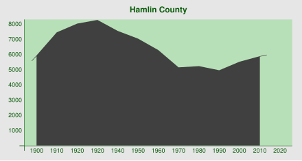
Population development
| 1900 | 1910 | 1920 | 1930 | 1940 | 1950 | 1960 | 1970 | 1980 | 1990 | 2000 | 2010 |
|---|---|---|---|---|---|---|---|---|---|---|---|
| 5945 | 7475 | 8054 | 8299 | 7562 | 7058 | 6303 | 5172 | 5261 | 4974 | 5540 | 5903 |
cities and communes
Cities ( cities )
Communities ( towns )
Web links
Commons : Hamlin County - collection of pictures, videos, and audio files
Individual evidence
- ↑ Hamlin County in the United States Geological Survey's Geographic Names Information System . Retrieved February 22, 2011
- ^ Hamlin County website .
- ↑ Search mask database in the National Register Information System. National Park Service , accessed July 31, 2018.
- ↑ 1900–1990 excerpt from Census.gov . Retrieved March 20, 2015
Coordinates: 44 ° 41 ′ N , 97 ° 12 ′ W

