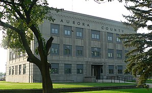
Aurora County
 Aurora County Courthouse |
|
| administration | |
|---|---|
| US state : | South Dakota |
| Administrative headquarters : | Plankinton |
| Foundation : | 1879 |
| Demographics | |
| Residents : | 2710 (2010) |
| Population density : | 1.5 inhabitants / km 2 |
| geography | |
| Total area : | 1845 km² |
| Water surface : | 11 km² |
| map | |
Aurora County is a county in the state of South Dakota in the United States . 3,058 residents lived here in 2000. The county seat is Plankinton .
history
Aurora County was formed on February 22, 1879 and finally organized on August 29, 1881. It was named after the Roman goddess of dawn at the suggestion of a literary club founded by the women of the first settlers . Plankinton became a county seat , an act ratified by voters in November 1882.

Nine structures and sites in the county are listed on the National Register of Historic Places (NRHP) (as of July 29, 2018).
geography
The county covers an area of 1,845 square kilometers. Of these, 11 square kilometers (0.61 percent) are water surfaces. It is bordered clockwise by the counties: Jerauld County , Sanborn County , Davison County , Douglas County , Charles Mix County, and Brule County .
| Population development | |||
|---|---|---|---|
| Census | Residents | ± in% | |
| 1900 | 4011 | - | |
| 1910 | 6143 | 53.2% | |
| 1920 | 7246 | 18% | |
| 1930 | 7139 | -1.5% | |
| 1940 | 5387 | -24.5% | |
| 1950 | 5020 | -6.8% | |
| 1960 | 4749 | -5.4% | |
| 1970 | 4183 | -11.9% | |
| 1980 | 3628 | -13.3% | |
| 1990 | 3136 | -13.6% | |
| 2000 | 3058 | -2.5% | |
| 2010 | 2710 | -11.4% | |
| 1900-1990
2000 |
|||
Townships
The county is divided into twenty townships :
|
|
|
|
|
Cities, villages etc.
- Aurora Center , unincorporated area
- Plankinton , town
- Stickney , community
- Storla , census-designated place
- White Lake , township
Individual evidence
- ^ Aurora County in the United States Geological Survey's Geographic Names Information System . Retrieved February 22, 2011
- ↑ Charles Curry Aiken, Joseph Nathan Kane: The American Counties: Origins of County Names, Dates of Creation, Area, and Population Data, 1950-2010 . 6th edition. Scarecrow Press, Lanham 2013, ISBN 978-0-8108-8762-6 , p. 13 .
- ↑ Search mask database in the National Register Information System. National Park Service , accessed July 29, 2018.
- ↑ Extract from Census.gov . Retrieved February 28, 2011
- ↑ Excerpt from factfinder.census.gov.Retrieved February 28, 2011
Web links
Coordinates: 43 ° 43 ′ N , 98 ° 34 ′ W
