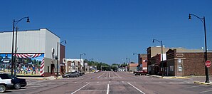
Lennox, South Dakota
| Lennox | |
|---|---|
 Lennox town center |
|
| Location in South Dakota | |
| Basic data | |
| Foundation : | 1889 (incorporated) |
| State : | United States |
| State : | South Dakota |
| County : | Lincoln County |
| Coordinates : | 43 ° 21 ′ N , 96 ° 54 ′ W |
| Time zone : | Central ( UTC − 6 / −5 ) |
| Residents : | 2,111 (as of 2010) |
| Population density : | 622.7 inhabitants per km 2 |
| Area : | 3.39 km 2 (approx. 1 mi 2 ) |
| Height : | 410 m |
| Postal code : | 57039 |
| Area code : | +1 605 |
| FIPS : | 46-36380 |
| GNIS ID : | 1256091 |
| Website : | www.cityoflennoxsd.com |
| Mayor : | Orville Wiebers |
Lennox is a small town (with the status " City ") in Lincoln County in US -amerikanischen State South Dakota . In 2010 Lennox had 2,111 inhabitants.
geography
Lennox is located in southeast South Dakota, around 30 km west of the Big Sioux River , which forms the border with Iowa . The geographical coordinates of Lennox are 43 ° 21'15 "north latitude and 96 ° 53'31" west longitude. The urban area extends over an area of 3.39 km².
Neighboring towns to Lennox are Tea (14.8 km northeast), Harrisburg (15.4 km northeast), Worthing (13.2 km east-southeast), Davis (19.3 km southwest), Hurley (15.8 miles west-southwest), and Chancellor (8.5 km west-northwest).
The closest major cities are Sioux Falls (35 km northeast), Minneapolis , Minnesota (415 km east-northeast), Rochester (413 km east), Iowa's capital Des Moines (438 km southeast), Omaha , Nebraska (280 km south) and Fargo in North Dakota (418 km north).
traffic
A few kilometers east of Lennox is Interstate 29 , which runs from Kansas City in Missouri to Winnipeg in the Canadian province of Manitoba . South Dakota Highways 17 and 44 meet in the southeast of the Lennox metropolitan area . All roads within the urban area are subordinate country roads, some unpaved roads or inner-city connecting roads.
A railway line of the BNSF Railway runs through the city of Lennox in a north-west-south-east direction for freight traffic .
The nearest airport is Sioux Falls Regional Airport , 23 miles northeast, South Dakota's largest airport.
Demographic data
| Population development | |||
|---|---|---|---|
| Census | Residents | ± in% | |
| 1880 | 89 | - | |
| 1890 | 363 | 307.9% | |
| 1900 | 591 | 62.8% | |
| 1910 | 745 | 26.1% | |
| 1920 | 1074 | 44.2% | |
| 1930 | 1113 | 3.6% | |
| 1940 | 1164 | 4.6% | |
| 1950 | 1218 | 4.6% | |
| 1960 | 1353 | 11.1% | |
| 1970 | 1487 | 9.9% | |
| 1980 | 1827 | 22.9% | |
| 1990 | 1767 | -3.3% | |
| 2000 | 2037 | 15.3% | |
| 2010 | 2111 | 3.6% | |
| 2012 estimate | 2201 | 4.3% | |
| 1880-2000 2010 2012 | |||
According to the 2010 census , Lennox had 2,111 people in 842 households. The population density was 622.7 inhabitants per square kilometer. Statistically, 2.41 people lived in each of the 842 households.
The racial the population was composed of 98.2 percent white, 0.1 percent African American, 0.6 percent Native American and 0.4 percent Asian; 0.6 percent were descended from two or more races. Hispanic or Latino of any race was 1.1 percent of the population.
26.4 percent of the population were under 18 years old, 57.6 percent were between 18 and 64 and 16.0 percent were 65 years or older. 50.6 percent of the population was female.
The average annual income for a household was 50,944 USD . The per capita income was $ 25,745. 8.9 percent of the population lived below the poverty line.
Web links
Individual evidence
- ↑ history.sd.gov - Towns (PDF; 45kB) Retrieved July 3, 2013
- ↑ a b c American Fact Finder. Retrieved July 3, 2013
- ↑ Distance information according to Google Maps. Accessed July 3, 2013
- ^ US Decennial Census. Retrieved July 3, 2013
- ↑ US Census Bureau - Estimate for 2012 ( Memento of the original from October 2, 2013 in the Internet Archive ) Info: The archive link was inserted automatically and has not yet been checked. Please check the original and archive link according to the instructions and then remove this notice. Retrieved July 3, 2013
