Coteau du Missouri


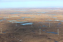
The Coteau du Missouri (also called Missouri Coteau / Couteau or Missouri Plateau , in German about Missouri slope or Missouri plateau ) is a flat ridge that extends east of the Missouri River from South Dakota via North Dakota to Saskatchewan . It forms the watershed between the Missouri and the Red River of the North . The plateau is characterized by numerous natural lakes and ponds that have their origin in the last glacial period .
The Couteau du Missouri drops significantly on the west side to the Drift Prairie , which is about 100 - 150 m lower . in the east it slowly merges into the Great Plains . This slowly sloping landscape is also called Coteau Slope , the lakes here drain into the Missouri Valley. In the southwest the plateau is broken by some glacial valleys . The glacial valley of the James River forms the southwestern border of the ridge.
Geologically , the plateau is part of the Great Plains and is separated from the main plateau in the west by the Missouri River. The subsoil of the plateau is slate , on which the deposits of the regularly recurring ice ages are deposited, including lignite , sodium sulfate and bentonite . In the last ice age maximum , the glaciers spread south and were deflected by the terrain of the Missouri Coteau. Large ice sheets with debris were deposited on the Missouri Plateau. After the end of the Cold Age, the ice melted, leaving today's landscape with a layer of sediment over 60 m thick and the so-called dead ponds .
The plateau itself is poorly drained, there are almost no streams or rivers. Since many of the lakes and wetlands have no natural runoff (they are also called endorheic lakes), some have become soda lakes . The area is part of the Prairie Pothole region .
The Missouri Plateau is predominantly overgrown by mixed grass prairie . Today the landscape is primarily a grain and pasture region.
See also
Web links
Individual evidence
- ↑ Dakota (Indian tribe) . In: Brockhaus Konversationslexikon . 14th edition. tape 4 . FA Brockhaus, Leipzig, Berlin and Vienna 1896, p. 1693 ( retrobibliothek.de [accessed on July 21, 2020]).
- ↑ a b Section 6: Missouri Plateau. In: North Dakota Studies. State Historical Society of North Dakota, accessed July 21, 2020 .
- ↑ a b Natural History. In: Kulm WMD. US Fish and Wildlife Service, December 13, 2013, accessed July 21, 2020 .
- ^ A b Douglas Malo: South Dakota's Physiographic Regions. 1997, archived from the original on April 9, 2014 ; accessed on July 21, 2020 (English).
- ↑ Lynden Penner: MISSOURI COTEAU. In: The Encyclopedia of Saskatchewan. Retrieved July 21, 2020 (English).
- ↑ a b Mixed-grass Prairie (Missouri Coteau). North Dakota Game and Fish Department, accessed July 21, 2020 .