Drift prairie
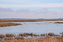
The Drift Prairie is a prairie landscape in North Dakota and South Dakota . It lies between the valley of the Red River of the North in the east and the high plateaus Coteau du Missouri and Coteau des Prairies in the west and south. To the north of the Drift Prairie are the Turtle Mountains and the Canadian border. The landscape was created in the last ice age when the glaciers spread south. The moraine landscape consists of flat hills and lakes and thus belongs to the Prairie Pothole region .
The Drift Prairie is a mixed grass prairie and forms the transition between the moister high grass prairie in the east and the drier short grass prairie of the Great Plains . It forms the US part of the so-called Northern Mixed Grasslands or Northern Glaciated Plains.
The largest rivers in the Drift Prairie are the Souris River , Sheyenne River, and James River . Some lakes, like Devils Lake , have no drainage, so they are endorheic and salty .
Individual evidence
- ↑ a b Section 5: Drift Prairie. In: North Dakota Studies. State Historical Society of North Dakota, accessed July 21, 2020 .
- ^ Eastern Mixed-grass Prairie (Drift Prairie). In: North Dakota Game and Fish. Retrieved July 21, 2020 (English).

