Sheyenne River
| Sheyenne River | ||
|
Catchment area of the Red River of the North, Sheyenne River highlighted |
||
| Data | ||
| Water code | US : 1035146 | |
| location | North Dakota (USA) | |
| River system | Nelson River | |
| Drain over | Red River of the North → Winnipeg Lake → Nelson River → Hudson Bay | |
| source | 15 miles north of McClusky 47 ° 41 ′ 46 ″ N , 100 ° 29 ′ 52 ″ W |
|
| muzzle | in the Red River of the North coordinates: 47 ° 1 '25 " N , 96 ° 49' 31" W 47 ° 1 '25 " N , 96 ° 49' 31" W. |
|
| Mouth height |
260 m
|
|
| length | 951 km | |
| Reservoirs flowed through | Lake Ashtabula | |
|
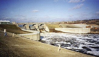
Baldhill Dam on the Sheyenne River during the 1996 spring flood |
||
The Sheyenne River is one of the major tributaries of the Red River of the North . It has a length of about 951 km and runs in eastern North Dakota .
The river has its origin 24 km north of McClusky . It flows mostly in an easterly direction before changing south near McVille . It then flows through Griggs County and Barnes Counties before turning northeast near Lisbon . The river is dammed north of Valley City from Baldhill Dam to Lake Ashtabula .
At Lisbon the river flows through the Sheyenne National Grassland and reaches Cass County near the town of Kindred .
This stretch of the river is popular with canoeists and outdoor enthusiasts. From Kindred, the river flows in a north-northeast direction through the fertile plains of the Red River Valley.
The character of the river changes when it leaves the sandy grasslands . Now it takes up the fertile clay soil of the Red River Valley. The river used to pose a flood hazard to the cities of West Fargo and Harwood , near which the Sheyenne River meets the Red River of the North . Thanks to a drainage canal built near Horace , the major cities on the Sheyenne River survived the 1997 floods. However, it struck the cities of Grand Forks and East Grand Forks .
Web links
Individual evidence
- ^ USGS - Geographic Names Information System
- ^ US Geological Survey. National Hydrography Dataset high-resolution flowline data. The National Map , accessed June 8, 2011

