Browns Valley
| Browns Valley | |
|---|---|
|
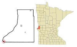
Location of Browns Valley in Traverse County
|
|
| Basic data | |
| State : | United States |
| State : | Minnesota |
| County : | Traverse County |
| Coordinates : | 45 ° 36 ′ N , 96 ° 50 ′ W |
| Time zone : | Central ( UTC − 6 / −5 ) |
| Residents : | 690 (as of: 2000) |
| Population density : | 345 inhabitants per km 2 |
| Area : | 2.0 km 2 (approx. 1 mi 2 ) of which 2.0 km 2 (approx. 1 mi 2 ) are land |
| Height : | 301 m |
| Postal code : | 562919 |
| Area code : | +1 320 |
| FIPS : | 27-08200 |
| GNIS ID : | 0659752 |
Browns Valley is a town in Traverse County , Minnesota , on the border with South Dakota .
geography
Browns Valley lies on the Little Minnesota River bank , between the northern end of Big Stone Lake and the southern end of Lake Traverse , which is separated from the Little Minnesota River by a low and narrow continental divide . The place and the two lakes are located in the so-called Traverse Gap , the bed of the former glacial River Warren , which was once a natural drain of Lake Agassiz. Today Lake Traverse is drained by the Bois de Sioux River . According to the United States Census Bureau , the place has an area of 2.0 km² , all land.
Demographics
The United States Census 2000 counted 690 residents in 285 households and 171 families in Browns Valley. The population density was 337.2 inhabitants / km². The number of residential units was 317, which corresponds to a density of 154.9 apartments / km².
The population in 2000 was 82.61% White , 15.80% Native American , 0.43% Asians , 0.14% Pacific Islanders , 0.14% of other races, and 0.87% of two or more more races off. 1.74% of the population stated in the census to be Hispanic or Latino .
Children under the age of 18 lived in 26.3% of households and married couples lived together in 45.3% of households, 9.5% of households had a female householder with no husband present, and 40.0% of households were non-families. 36.5% of all households were made up of individuals and 21.4% had someone age 65 or older living alone. The average household size was 2.29 people and the average family consisted of 3.02 people.
Of the population, 24.5% were less than 18 years old, 18.7% were in the 18 to 24 age group, 17.8% were between 25 and 44 years old and 19.3% were between 45 and 64 years old. 31.0% were 65 years of age or older. The median age was 45 years. For every 100 women there were 86.5 men; For every 100 women over 18, there were 82.2 men.
The average income per household was 26,563 US $ and the median family income was 30,208 US $. The men had an average income of $ 25,500 compared to $ 20,139 for women. The per capita income was US $ 15,062. About 10.3% of families and 14.4% of the population are below the poverty line ; this affected 16.5% of those under 18 years of age and 11.0% of those aged 65 or older.
Floods

Since the height differences in the Traverse Gap are very small, the water of the Mississippi River, which is part of the catchment area of the Mississippi River, which drains into the Gulf of Mexico, can cross the continental divide and flow into Lake Traverse in the event of flooding . This drains through the Bois de Sioux River and the Red River of the North into Lake Winnipeg and on to Hudson Bay . A dam built by the United States Army Corps of Engineers protects Browns Valley from flooding from Lake Traverse.
sons and daughters of the town
- Charles Milby Dale (1893–1978), politician and Governor of New Hampshire from 1945 to 1949
- Arthur Emanuel Nelson (1892–1955), politician who briefly represented the state of Minnesota in the US Senate
Web links
- Browns Valley, MN Spring 2007 . Flooding. JOR Engineering, Inc. (March 14, 2007). Retrieved May 15, 2007. Aerial images showing the Browns Valles flooding in March 2007. (English)
