Wheaton, Minnesota
| Wheaton | |
|---|---|
|
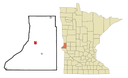
Location in Minnesota
|
|
| Basic data | |
| Foundation : | 1884 (founded) 1897 (incorporated) |
| State : | United States |
| State : | Minnesota |
| County : | Traverse County |
| Coordinates : | 45 ° 48 ′ N , 96 ° 30 ′ W |
| Time zone : | Central ( UTC − 6 / −5 ) |
| Residents : | 1,424 (as of 2010) |
| Population density : | 305.6 inhabitants per km 2 |
| Area : | 4.66 km 2 (approx. 2 mi 2 ) |
| Height : | 310 m |
| Postal code : | 56296 |
| Area code : | +1 320 |
| FIPS : | 27-69844 |
| GNIS ID : | 654055 |
| Website : | cityofwheaton.com |
| Mayor : | Leonard Zimmel |
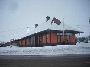
 Station building on the former Milwaukee Road in Wheaton, listed on the NRHP since 1985 |
|
Wheaton is a small town (with the status " City ") and the administrative seat of the Traverse County in the US -amerikanischen State Minnesota . In 2010 Wheaton had 1,424 residents.
geography
Wheaton is located in western Minnesota on the Mustinka River , a tributary of Lake Traverse and thus part of the catchment area of the Red River of the North . The geographical coordinates of Wheaton are 45 ° 48'17 "north latitude and 96 ° 29'46" west longitude. The urban area extends over an area of 4.66 km².
Neighboring locations to Wheaton are Norcross (17 miles east-northeast), Dumont (11.9 km southeast), Rosholt in South Dakota (14 miles northwest) and White Rock in South Dakota at the intersection of the states of South Dakota and North Dakota and Minnesota (11.1 miles northwest).
The closest major cities are Fargo , North Dakota (129 km north), Duluth on Lake Superior (415 km east-northeast), Minneapolis (297 km east-southeast), Minnesota's capital city of Saint Paul (315 km in the same direction), and Sioux Falls , South Dakota (280 km south).
traffic
In the urban area of Wheaton, US Highway 75 and Minnesota State Route 27 intersect . All other roads are subordinate country roads, some unpaved roads and inner-city connecting roads.
With the Wheaton Municipal Airport there is a small airfield 4.9 km southwest. The nearest major airports are the Hector Regional Airport in Fargo (139 km north), the Sioux Falls Regional Airport (274 km south) and the Minneapolis-Saint Paul International Airport (317 km east-southeast).
history
Wheaton was founded in 1884 within the Lake Valley Township . In 1887 the place was removed from the township and incorporated as the Village of Wheaton . In 1886 the county seat was moved from Browns Valley to Wheaton. Wheaton was named after Daniel Thompson Wheaton , a railway surveyor.
Demographic data
| Population development | |||
|---|---|---|---|
| Census | Residents | ± in% | |
| 1890 | 883 | - | |
| 1900 | 1132 | 28.2% | |
| 1910 | 1300 | 14.8% | |
| 1920 | 1337 | 2.8% | |
| 1930 | 1279 | -4.3% | |
| 1940 | 1700 | 32.9% | |
| 1950 | 1948 | 14.6% | |
| 1960 | 2102 | 7.9% | |
| 1970 | 2029 | -3.5% | |
| 1980 | 1969 | -3% | |
| 1990 | 1615 | -18% | |
| 2000 | 1619 | 0.2% | |
| 2010 | 1424 | -12% | |
| 1890-2000 2010 | |||
According to the 2010 census , Wheaton had 1,424 people in 655 households. The population density was 305.6 inhabitants per square kilometer. Statistically, 2.08 people lived in each of the 655 households.
The racial the population was composed of 97.4 percent white, 0.6 percent African American, 0.7 percent Native American, 0.1 percent Asian, 0.1 percent Polynesian and 0.2 percent from other ethnic groups; 1.0 percent were descended from two or more races. Regardless of ethnicity, 1.5 percent of the population was Hispanic or Latino of any race.
20.4 percent of the population were under 18 years old, 48.1 percent were between 18 and 64 and 31.5 percent were 65 years or older. 52.8 percent of the population was female.
The average annual income for a household was 42,950 USD . The per capita income was $ 26,383. 8.5 percent of the population lived below the poverty line.
Individual evidence
- ↑ Extract from the National Register of Historic Places - No. 85001818 Retrieved June 29, 2013
- ↑ a b c American Fact Finder. Retrieved June 29, 2013
- ↑ Distance information according to Google Maps. Accessed April 23, 2013
- ↑ AirNav.com - Wheaton Municipal Airport Accessed on 29 June 2013
- ↑ LakesnWoods.com - Wheaton, Minnesota Retrieved on June 29, 2013
- ↑ US Decennial Census. Retrieved June 29, 2013
