Granite Falls, Minnesota
| Granite Falls | |
|---|---|
 Prentice Street in Granite Falls (2007) |
|
| Location in county and Minnesota | |
| Basic data | |
| State : | United States |
| State : | Minnesota |
| Counties : |
Yellow Medicine County Chippewa County |
| Coordinates : | 44 ° 49 ′ N , 95 ° 33 ′ W |
| Time zone : | Central ( UTC − 6 / −5 ) |
| Residents : | 2,897 (as of 2010) |
| Population density : | 325.5 inhabitants per km 2 |
| Area : | 9.6 km 2 (about 4 mi 2 ) of which 8.9 km 2 (about 3 mi 2 ) is land |
| Height : | 280 m |
| Postal code : | 56241 |
| Area code : | +1 320 |
| FIPS : | 27-25280 |
| GNIS ID : | 0644347 |
| Website : | www.granitefalls.com |
| Mayor : | Dave Smiglewski |
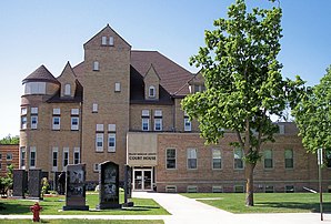
 Yellow Medicine County Courthouse (2007) |
|
Granite Falls is a small town (with the status " City ") in southwestern US -amerikanischen state of Minnesota . The city is the administrative seat of Yellow Medicine County , but half is also in Chippewa County . In 2010 , Granite Falls had 2,897 residents.
The Andrew John Volstead House , the home of the politician Andrew Volstead , who was instrumental in bringing about Prohibition , is located in Granite Falls. The building has been included in both the Register of Historic Landmarks and Historic Places .
geography
Granite Falls lies on both sides of the Minnesota River at 44 ° 48'38 "north latitude and 95 ° 32'36" west longitude. The city extends over 9.6 km², which is spread over 8.9 km² of land and 0.7 km² of water.
Neighboring locations to Granite Falls are Montevideo (14 miles northwest), Sacred Heart (10 miles east), Hanley Falls (10 miles southwest), and Clarkfield (13 miles west).
The nearest major cities are Minneapolis (201 km east), Minnesota's capital Saint Paul (217 km in the same direction), Rochester (310 km east-southeast), Sioux Falls in South Dakota (192 km southwest) and Fargo , North Dakota (287 km north-northwest).
traffic
US Highway 212 and Minnesota State Routes 23 and 67 meet in Granite Falls . A road bridge over the Minnesota River is on the north and south edges of the city center. All other roads are subordinate country roads, partly unpaved roads or inner-city connecting roads.
A railway line of the Twin Cities and Western Railroad runs along the north bank of the Minnesota River . A stretch of the BNSF Railway runs through the west of the urban area, crosses the Minnesota River in the northwest via a rail bridge and crosses the other railway line to the north.
The Granite Falls Municipal Airport South is located 7.7 kilometers of the city. The nearest major airport is Minneapolis-Saint Paul International Airport (198 km east).
Demographic data
| Population development | |||
|---|---|---|---|
| Census | Residents | ± in% | |
| 1880 | 578 | - | |
| 1890 | 800 | 38.4% | |
| 1900 | 1214 | 51.8% | |
| 1910 | 1454 | 19.8% | |
| 1920 | 1611 | 10.8% | |
| 1930 | 1791 | 11.2% | |
| 1940 | 2388 | 33.3% | |
| 1950 | 2511 | 5.2% | |
| 1960 | 2728 | 8.6% | |
| 1970 | 3225 | 18.2% | |
| 1980 | 3451 | 7% | |
| 1990 | 3083 | -10.7% | |
| 2000 | 3070 | -0.4% | |
| 2010 | 2897 | -5.6% | |
| 1880-2000 2010 | |||
According to the 2010 census , Granite Falls had 2,897 people in 1,282 households. The population density was 325.5 inhabitants per square kilometer. Statistically, 2.17 people lived in 1282 households.
The racial the population was composed of 89.9 percent white, 0.6 percent African American, 5.2 percent Native American, 0.4 percent Asian and 1.8 percent from other ethnic groups; 2.1 percent were descended from two or more races. Hispanic or Latino of any race was 4.7 percent of the population.
21.5 percent of the population were under 18 years old, 57.8 percent were between 18 and 64 and 20.7 percent were 65 years or older. 51.6 percent of the population was female.
The average annual income for a household was 38,942 USD . The per capita income was $ 20,791. 16.8 percent of the population lived below the poverty line.
Tornado on July 25, 2000
On July 25, 2000, a tornado raged in Granite Falls and Yellow Medicine Counties. The funnel of the tornado dipped to the ground in rural areas of the county west-northwest of Granite Falls and hit Granite Falls at 6:10 pm. The tornado moved through the inhabited parts of the city and after 15 km on the ground rose again at around 6:25 p.m. One person was killed and more than a dozen injured. The damage to property in the city and its surroundings ran into the millions. Most of the damage in Granite Falls was equivalent to that of an F-2 and F-3 tornado on the Fujita scale , but the extent of damage to the corner of 9th Avenue and 14th Street caused the National Weather Service to assess the intensity of the Classify tornadoes as F-4. It was one of the strongest tornadoes in the history of the state .
Individual evidence
- ↑ a b c American Fact Finder. Retrieved April 9, 2013
- ↑ Distance information according to Google Maps. Accessed April 9, 2013
- ^ US Decennial Census. Retrieved April 9, 2013
Web links
- Official website
- Granite Falls Tornado July 25, 2000 National Weather Service
- www.city-data.com - Granite Falls, Minnesota
