Lac qui Parle River
| Lac qui Parle River | ||
|
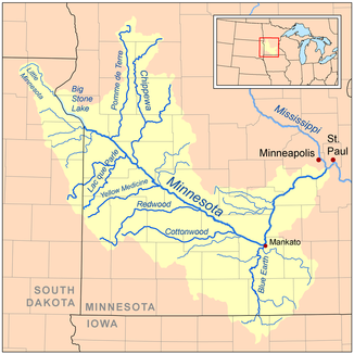
Location of the Lac qui Parle River in the Minnesota River basin |
||
| Data | ||
| Water code | US : 646304 | |
| location | Minnesota (USA) | |
| River system | Mississippi River | |
| Drain over | Minnesota River → Mississippi River → Gulf of Mexico | |
| source |
Lake Hendricks near Hendricks , Lincoln County 44 ° 30 ′ 17 ″ N , 96 ° 26 ′ 6 ″ W. |
|
| Source height | 535 m | |
| muzzle |
Minnesota River , Lac qui Parle County Coordinates: 45 ° 1 '35 " N , 95 ° 52' 49" W 45 ° 1 '35 " N , 95 ° 52' 49" W. |
|
| Mouth height | 287 m | |
| Height difference | 248 m | |
| Bottom slope | 1.3 ‰ | |
| length | 190 km | |
| Catchment area | 2994 km² | |
| Drain |
MQ |
4 m³ / s |
| Left tributaries | West Branch Lac qui Parle River | |
| Small towns | Dawson | |
|
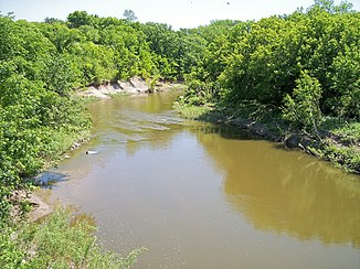
Lac qui Parle River in Lac qui Parle Township (2007) |
||
|
Lac qui Parle River in Lac qui Parle Township (2007) |
||
The Lac qui Parle River is a 190 km long tributary of the Minnesota River in southwest Minnesota in the United States .
A number of tributaries of the river also run east of neighboring South Dakota , including the largest of them, the West Branch Lac qui Parle River , which also flows through eastern South Dakota. Across the Minnesota River, the Lac qui Parle River is part of the catchment area of the Mississippi River and drains an area of 2994 km² in an agricultural region. A little more than two-thirds of this catchment area is within the state of Minnesota. Lac qui parle means “the lake that speaks” in French . This was a translation of the Sioux name for the Lac qui Parle , a lake that lies above the confluence of the Lac qui Parle River and the Minnesota River.
The origin of the river is in Lake Hendricks on the border between the counties of Lincoln and Brookings . It leaves the lake in Hendricks and flows as a non-permanent watercourse northwest through Lincoln County on the Coteau des Prairies , a moraine plateau that separates the catchment areas of the Mississippi and Missouri rivers . From there it flows into the west of Yellow Medicine County , where it leaves the Coteau and within 13 km loses 76 m in height. The river continues on its way to the northwest through a flat moraine plain. In this area, willows and poplars grow on its banks. The river then enters the east of Lac qui Parle County , where it flows east past Dawson . Below Lac qui Parle in Lac qui Parle State Park , the river empties into the Minnesota River, about 15 km northwest of Montevideo , after flowing through a wooded valley in which it descended 64 m within 29 km.
The largest tributary is the 89 km long West Branch Lac qui Parle River , which rises on the Coteau in the east of Deuel County in South Dakota and initially flows northeast, passing Gary and then flowing east past Dawson through Lac qui Parle County . Other tributaries include the 39 km long Canby Creek , which flows northeast on the Coteau through the west of Yellow Medicine County and the town of Canby , and the Tenmile Creek , whose 53 km long course runs east and north through Lac qui Parle County with the place Boyd leads.
According to the Minnesota Pollution Control Agency, 79% of Minnesota’s catchment area of 2088 km² is used for agriculture, primarily for growing corn and soybeans .
Flow rate
At the level of the United States Geological Survey near the municipality of Lac qui Parle, the long-term average of the water volume of the river was four m³ / s between 1910 and 2005. The highest value was recorded at 484 m³ / s on April 10, 1969, the lowest value zero m³ / s occurred in dry periods of several years.
Web links
Individual evidence
- ↑ a b c G. B. Mitton, KG Guttormson, GW Stratton, ES Wakeman: Water Resources Data in Minnesota, Water Year 2005 Annual Report. . United States Geological Survey . S. Lac qui Parle River near Lac qui Parle, MN (PDF; 141 kB). Retrieved June 5, 2007.
- ↑ Lac qui Parle River in the Geographic Names Information System of the United States Geological Survey
- ↑ a b c Watersheds of the Minnesota River Basin. . Minnesota Pollution Control Agency. S. Minnesota River Basin: Lac qui Parle Watershed . December 1, 2005. Archived from the original on February 5, 2007. Info: The archive link was automatically inserted and not yet checked. Please check the original and archive link according to the instructions and then remove this notice. Retrieved June 5, 2007.
- ^ A b c Thomas F. Waters: The Southwest: Rivers of the Coteau des Prairies . In: The Streams and Rivers of Minnesota . University of Minnesota Press , Minneapolis 2006, ISBN 0-8166-0960-8 , pp. 288-303.
- ^ A b Minnesota Atlas & Gazetteer . DeLorme , Yarmouth, Me. 1994, ISBN 0-89933-222-6 , pp. 28, 36-37.
- ↑ Lac qui Parle River in the Geographic Names Information System of the United States Geological Survey
- ↑ Lac qui Parle River Major Watershed. . Minnesota River Basin Data Center. Minnesota State University, Mankato . S. Streams within the Lac qui Parle River Major Watershed . June 6, 2000. Retrieved June 5, 2007.
- ^ South Dakota Atlas & Gazetteer . DeLorme , Yarmouth, Me. 2001, ISBN 0-89933-330-3 , p. 35.


