Chan hating
| Chan hating | |
|---|---|
|
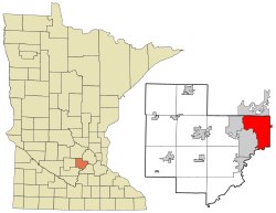
Location in Minnesota
|
|
| Basic data | |
| Foundation : | 1896 |
| State : | United States |
| State : | Minnesota |
| Counties : |
Carver County Hennepin County |
| Coordinates : | 44 ° 52 ′ N , 93 ° 32 ′ W |
| Time zone : | Central ( UTC − 6 / −5 ) |
|
Inhabitants : - Metropolitan Area : |
22,952 (status: 2010) 3,279,833 (status: 2010) |
| Population density : | 433.5 inhabitants per km 2 |
| Area : | 59.26 km 2 (approx. 23 mi 2 ) of which 52.94 km 2 (approx. 20 mi 2 ) is land |
| Height : | 297 m |
| Postal code : | 55317 |
| Area code : | +1 952 |
| FIPS : | 27-10918 |
| GNIS ID : | 641106 |
| Website : | www.ci.chanhassen.mn.us |
| Mayor : | Denny Laufenburger |
Chanhassen is a city (with the status " City ") in Carver County and to a lesser extent in Hennepin County in the US -amerikanischen State Minnesota . In 2010 , Chanhassen had 22,952 residents.
Chanhassen is part of the Minneapolis-Saint Paul metropolitan area .
geography
Chanhassen is located in the southwestern suburban area of Minneapolis on the north bank of the Minnesota River at 44 ° 51'44 "north latitude and 93 ° 31'51" west longitude. The city extends over 59.26 km², which is spread over 52.94 km² of land and 6.32 km² of water.
Neighboring places to Chanhassen are Shorewood (on the northern city limits), Minnetonka (10.1 km northeast), Eden Prairie (on the eastern city limits), Shakopee (on the southern city limits across the Minnesota River), Chaska (on the southwestern city limits) and Victoria (on the western city limits).
Downtown Minneapolis is 20 miles northeast; the center of Saint Paul , the capital of Minnesota, is 44.3 km east-northeast.
traffic
The four-lane US Highway 212 runs as a southwestern arterial road through the southeastern districts of Chanhassen. Minnesota State Route 5 runs through the city center and runs west from the southern suburbs of Minneapolis and Saint Paul. All other roads are subordinate routes as well as inner-city connecting roads.
The main line of the Twin Cities and Western Railroad , founded in 1991 and running west from Minneapolis, runs through Chanhassen .
The closest airport is Flying Cloud Airport , 11.7 km southeast, while the larger and more modern Minneapolis-Saint Paul International Airport is 30.3 km east of Chanhassen.
history
| Population development | |||
|---|---|---|---|
| Census | Residents | ± in% | |
| 1900 | 175 | - | |
| 1910 | 164 | -6.3% | |
| 1920 | 129 | -21.3% | |
| 1930 | 128 | -0.8% | |
| 1940 | 132 | 3.1% | |
| 1950 | 182 | 37.9% | |
| 1960 | 244 | 34.1% | |
| 1970 | 4879 | 1,899.6% | |
| 1980 | 6359 | 30.3% | |
| 1990 | 11,732 | 84.5% | |
| 2000 | 20,321 | 73.2% | |
| 2010 | 22,952 | 12.9% | |
| 1900-2000 2010 | |||
The word Chanhassen comes from the Dakota language and means sugar maple tree .
The first white settlers were German immigrants who came to the area in the 1850s and settled as farmers in what is now the urban area. The construction of the railroad brought more settlers to the area. In 1896 the settlement was given the official status of "Village".
The town did not grow at a rapid pace until the 1960s, when Chanhassen developed from a rural settlement to a wealthy Minneapolis suburb. In 1967 the community of Chanhassen was united with the surrounding township to form the City of Chanhassen.
In 2009, Chanhassen was ranked second among the most popular small town places to live , according to CNNmoney.com .
Demographic data
According to the 2010 census , Chanhassen had 22,952 people in 8,352 households. The population density was 433.5 inhabitants per square kilometer. Statistically, 2.75 people lived in each of the 8352 households.
The racial the population was composed of 92.5 percent white, 1.1 percent African American, 0.1 percent Native American, 3.9 percent Asian and 0.9 percent from other ethnic groups; 1.5 percent were descended from two or more races. Hispanic or Latino of any race was 2.3 percent of the population.
30.2 percent of the population were under 18 years old, 62.1 percent were between 18 and 64 and 7.7 percent were 65 years or older. 50.9 percent of the population was female.
The average annual income for a household was 102,700 USD . The per capita income was $ 46,067. 2.8 percent of the population lived below the poverty line.
Individual evidence
- ↑ a b c American Fact Finder. Retrieved February 10, 2013
- ↑ Distance information according to Google Maps. Accessed on February 10, 2013
- ^ US Decennial Census. Retrieved February 10, 2013
- ^ History of Chanhassen. Retrieved February 10, 2013
- ↑ CNN Money - 2009. Retrieved February 10, 2013
