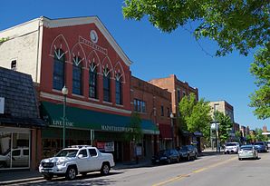
Hopkins, Minnesota
| Hopkins | |
|---|---|
 City Hall by Hopkins |
|
| Location in Minnesota | |
| Basic data | |
| Foundation : | 1887 (as West Minneapolis ) |
| State : | United States |
| State : | Minnesota |
| County : | Hennepin County |
| Coordinates : | 44 ° 56 ′ N , 93 ° 28 ′ W |
| Time zone : | Central ( UTC − 6 / −5 ) |
|
Inhabitants : - Metropolitan Area : |
17,591 (status: 2010) 3,279,833 (status: 2010) |
| Population density : | 1,653.3 inhabitants per km 2 |
| Area : | 10.64 km 2 (approx. 4 mi 2 ) |
| Height : | 314 m |
| Postcodes : | 55305, 55343, 55345 |
| Area code : | +1 952 |
| FIPS : | 27-30140 |
| GNIS ID : | 645180 |
| Website : | www.hopkinsmn.com |
| Mayor : | Gene Maxwell |
 Downtown Hopkins |
|
Hopkins is a city (with the status " City ") in Hennepin County in the southeastern center of the US -amerikanischen state of Minnesota . In 2010 , Hopkins had 17,591 residents.
Hopkins is part of the Minneapolis-Saint Paul metropolitan area .
geography
Hopkins is located in the western suburbs of Minneapolis at 44 ° 55'30 "north latitude and 93 ° 27'46" west longitude. The city extends over 10.64 km².
Places adjacent to Hopkins are St. Louis Park (on the northeastern city limits), Edina (on the southeastern city limits) and Minnetonka (on the southwest, west and northwestern city limits).
Downtown Minneapolis is 9 miles east-northeast; downtown Saint Paul , capital of Minnesota, is 20 miles east.
traffic
The main artery of road traffic through Hopkins is formed by the four-lane US Highway 169 , which also serves as one of several western bypasses of the Twin Cities . In the north of the metropolitan area, US 169 is crossed by Minnesota State Route 7 . All other roads are subordinate routes as well as inner-city connecting roads.
The main line of the Twin Cities and Western Railroad , which runs west from Minneapolis, runs through Hopkins . The northern city limit is formed by a line of the BNSF Railway , the second largest railway company in the country.
Several footpaths and cycle paths, known as rail trails , lead through the city on the routes of former railway lines .
The nearest airport is Minneapolis-Saint Paul International Airport (26.2 km south-southeast).
history
The first white settlers came to the area around today's city in 1852. The core of the city was formed in 1887 by the settlement of an agricultural machinery factory including the construction of houses for their employees.
In 1893, at the request of citizens to the county government, the self-governing Village of West Minneapolis was formed.
In 1928 the name of the place was changed to Hopkins, the name of one of the town's first settlers and postmasters.
In 1947 a new municipal constitution was passed and the municipal status was changed to "City".
Demographic data
| Population development | |||
|---|---|---|---|
| Census | Residents | ± in% | |
| 1910 | 3022 | - | |
| 1920 | 3055 | 1.1% | |
| 1930 | 3834 | 25.5% | |
| 1940 | 4100 | 6.9% | |
| 1950 | 7595 | 85.2% | |
| 1960 | 11,370 | 49.7% | |
| 1970 | 13,428 | 18.1% | |
| 1980 | 15,336 | 14.2% | |
| 1990 | 16,534 | 7.8% | |
| 2000 | 17,145 | 3.7% | |
| 2010 | 17,591 | 2.6% | |
| 1910-2000 2010 | |||
According to the 2010 census , Hopkins had 17,591 people in 8,366 households. The population density was 1,653.3 people per square kilometer. Statistically speaking, 2.07 people lived in the 8366 households.
The racial the population was composed of 70.4 percent white, 13.5 percent African American, 0.6 percent Native American, 8.5 percent Asian and 3.4 percent from other ethnic groups; 3.6 percent were descended from two or more races. Regardless of ethnicity, 7.9 percent of the population was Hispanic or Latino of any race.
21.1 percent of the population were under 18 years old, 66.3 percent were between 18 and 64 and 12.6 percent were 65 years or older. 52.4 percent of the population was female.
The average annual income for a household was 48,533 USD . The per capita income was $ 29,498. 11.9 percent of the population lived below the poverty line.
Personalities
- Jim Korn (born 1957), ice hockey player
- Samantha Harris (* 1973), actress and presenter
- Travis Boyd (born 1993), ice hockey player
Individual evidence
- ↑ a b c American Fact Finder. Retrieved February 27, 2013
- ↑ Distance information according to Google Maps. Accessed on February 27, 2013
- ↑ History of Hopkins ( Memento of the original from December 11, 2013 in the Internet Archive ) Info: The archive link was inserted automatically and has not yet been checked. Please check the original and archive link according to the instructions and then remove this notice. Retrieved February 27, 2013
- ↑ US Decennial Census. Retrieved February 27, 2013
