St. Louis Park
| St. Louis Park | |
|---|---|
|
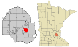
Location of St. Louis Park in Hennepin County and Minnesota
|
|
| Basic data | |
| Foundation : | 1886 |
| State : | United States |
| State : | Minnesota |
| County : | Hennepin County |
| Coordinates : | 44 ° 57 ′ N , 93 ° 21 ′ W |
| Time zone : | Central ( UTC − 6 / −5 ) |
| Residents : | 44,126 (as of: 2000) |
| Population density : | 1,593 inhabitants per km 2 |
| Area : | 28.3 km 2 (approx. 11 mi 2 ) of which 27.7 km 2 (approx. 11 mi 2 ) are land |
| Height : | 280 m |
| Postcodes : | 55416, 55426, 55424 |
| Area code : | +1 952 |
| FIPS : | 27-57220 |
| GNIS ID : | 2396500 |
| Website : | www.stlouispark.org |
| Mayor : | Jeff Jacobs (DFL) |
St. Louis Park is a city in Hennepin County . It is in the metropolitan area of Minneapolis-St. Paul is located in the US state of Minnesota and has a population of around 44,100.
geography
Geographical location
St. Louis Park is located in the US state of Minnesota in the American Midwest . In the east the city borders on Minneapolis . Other neighboring cities are Edina , Golden Valley , Minnetonka , Plymouth and Hopkins . According to the United States Census Bureau , the area of the city is 28.3 square kilometers, of which 0.5 square kilometers is water.
climate
St. Louis Park has a typical Minnesota continental climate . Summers are hot and humid, while winters are cold with little rainfall. The annual average temperature is around seven degrees Celsius. St. Louis Park itself does not have an NCDC weather station .
history
St. Louis Park was built on the site of the Elmwood settlement founded in the 1850s by settlers of European descent , which is still a residential area in the center of the city today. In November 1886, 31 residents signed the petition to establish a village . The name comes from the Minneapolis and St. Louis Railroad that runs through the village . In contrast to St. Louis in Missouri , the addition Park was selected. The establishment of the Village was accompanied by the establishment of a St. Louis Park Land and Improvement Company . Five Minneapolis businessmen and two landowners had started it. In the years that followed, St. Louis Park saw great growth. New hotels emerged and various agricultural and industrial companies settled here. Growth was only slowed down by the economic crisis in 1893.
The Peavey-Haglin Experimental Concrete Grain Elevator was built in St. Louis Park from 1899 to 1900 and was the first concrete, round wheat silo in the United States.
At the beginning of the 20th century, St. Louis Park became one of the first Minneapolis suburbs . The development benefited from the connection to the Streetcar network, which offered the population a quick connection to Minneapolis. From 1920 to 1930 the population grew from 2281 to 4710 inhabitants. This development accelerated after the Second World War. The population rose from just under 8,000 in 1940 to over 30,000 in 1955. In 1954, St. Louis Park was granted city rights with the successful vote on a home rule charter. Since the 1970s, the city has reached its natural growth limit. Since then, priority has been given to projects to improve the quality of life and beautify the city.
Population development
| 1920 | 1930 | 1940 | 1970 | 1980 | 1990 | 2000 |
|---|---|---|---|---|---|---|
| 2,281 | 4,170 | 7,737 | 48,883 | 42,931 | 43,787 | 44,126 |
Demographic data
According to the 2000 census , St. Louis Park has 44,126 people in 20,782 households and 10,557 families. The racial the population is made up of 98.9 percent white population, 4.4 percent African American, 3.2 percent Asian American and smaller minorities. 2.9 percent of the population are Hispanics .
Children under the age of 18 live in 22.0% of the 20,782 households, married couples in 39.3%, female singles in 8.6% and 49.2% are not family households. 37.9% of all households consist exclusively of a single person and 10.4% are single people over 65 years of age. The average household size is 2.08 people, that of families 2.81.
In relation to the entire city, the population is made up of 18.8% residents under 18 years of age, 8.7% between 18 and 24 years of age, 37.7% between 25 and 44 years of age, 20.2% between 45 and 64 years of age 14.7% over 65 years. The median is 36 years. About 52.5% of the population is female.
The median income of a household is USD 49,260 and that of a family is USD 63,182. The per capita income is $ 28,970. About 5.2% of the population and 3.0% of families live below the poverty line.
traffic
Major roads through St. Louis Park are US Highway 169 , which runs west of the city, as well as Minnesota State Route 100 and Minnesota State Route 7 . The Interstate 394 north of the city connects St. Louis Park with Minneapolis and Interstate 94 . Two railway lines also run through the city.
The nearest commercial airport is around 14 kilometers southeast of Minneapolis-Saint Paul International Airport .
economy
The ten largest employers in St. Louis Park in 2017 were:
| employer | Workers |
|---|---|
| Park Nicollet Health Services and Methodist Hospital | 6,286 |
| Wells Fargo | 1,450 |
| St. Louis Park Public Schools | 950 |
| Japs-Olson Company | 659 |
| MoneyGram | 409 |
| HealthPartners | 400 |
| Center for Diagnostic Imaging | 387 |
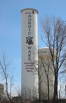
| Nordic goods | 350 |
| City of St. Louis Park | 277 |
| AAA Minneapolis | 205 |
education
St. Louis Park has seven public schools (three primary schools, two intermediate schools, and one junior and one senior high school each) with around 4,200 students, as well as nine private schools.
sons and daughters of the town
- Ethan and Joel Coen (* 1954 and 1957 respectively), film directors, producers and screenwriters
- Thomas L. Friedman (* 1953), journalist
Individual evidence
- ↑ St. Louis Park Financial Report 2017 , accessed October 21, 2018

