West St. Paul
| West St. Paul | |
|---|---|
|
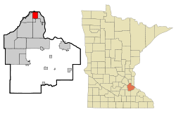
Location in Minnesota
|
|
| Basic data | |
| Foundation : | 1889 |
| State : | United States |
| State : | Minnesota |
| County : | Dakota County |
| Coordinates : | 44 ° 55 ′ N , 93 ° 6 ′ W |
| Time zone : | Central ( UTC − 6 / −5 ) |
|
Inhabitants : - Metropolitan Area : |
19,540 (as of 2010) 3,279,833 (as of 2010) |
| Population density : | 1,505.4 inhabitants per km 2 |
| Area : | 12.98 km 2 (approx. 5 mi 2 ) |
| Height : | 313 m |
| Postal code : | 55118 |
| Area code : | +1 651 |
| FIPS : | 27-69700 |
| GNIS ID : | 654003 |
| Website : | www.cityofwsp.org |
| Mayor : | John Zanmiller |
West St. Paul is a city (with the status " City ") in Dakota County in the US -amerikanischen State Minnesota . In 2010 West St. Paul had 19,540 residents.
West St. Paul is part of the Minneapolis-Saint Paul metropolitan area .
geography
West St. Paul is located in the southern suburb of Saint Paul , not far from the Mississippi , at 44 ° 54'58 "north latitude and 93 ° 06'06" west longitude. The city extends over 12.98 km².
Neighboring locations to West St. Paul are Saint Paul (on the northern city limits), South St. Paul (on the eastern city limits), Inver Grove Heights (11.1 km southeast), Sunfish Lake (6.1 km south), and Mendota Heights (on the western and southwestern city limits).
Downtown Minneapolis is 13 miles northwest; downtown Saint Paul, the capital of Minnesota, is 4.8 miles north.
traffic
The four-lane US Highway 52 runs along the eastern city limits, one of the southern arterial roads from Saint Paul. The Minnesota State Route 13 reached at the confluence with the Minnesota State Route 149 in the extreme northwest of the urban area its northern end. The Minnesota State Route 110 forms the city limits in the extreme southwest. All other roads are subordinate routes or inner-city connecting roads.
The nearest airport is St. Paul Downtown Airport , 6.8 km northeast ; the larger Minneapolis-Saint Paul International Airport is 14.3 km to the west.
history
| Population development | |||
|---|---|---|---|
| Census | Residents | ± in% | |
| 1890 | 1596 | - | |
| 1900 | 1830 | 14.7% | |
| 1910 | 2660 | 45.4% | |
| 1920 | 2962 | 11.4% | |
| 1930 | 4463 | 50.7% | |
| 1940 | 5733 | 28.5% | |
| 1950 | 7955 | 38.8% | |
| 1960 | 13.101 | 64.7% | |
| 1970 | 18.802 | 43.5% | |
| 1980 | 18,527 | -1.5% | |
| 1990 | 19,248 | 3.9% | |
| 2000 | 19,405 | 0.8% | |
| 2010 | 19,540 | 0.7% | |
| 1890-2000 2010 | |||
Until the mid-19th century, the region was of Dakota - Indians settled.
The first white settlers came in 1848. In 1855, the planned settlement began. In 1958 a commune with the name West St. Paul was founded for the first time . However, it was the part of today's metropolitan area of Saint Paul that lies west of the Mississippi.
In 1887 the city of South St. Paul was founded, which also included what is now the city of West St. Paul. In 1889 the western part was separated and today's city of West St. Paul was created.
According to the municipal constitution ( City Charter ) of 1907, the city has a mayor and seven city council members, who are elected. In 1962 the city manager function was added, so that the mayor and city council form the legislature and the city manager presides over the executive.
Demographic data
According to the 2010 census , West St. Paul had 19,540 people in 8,529 households. The population density was 1505.4 inhabitants per square kilometer. Statistically, 2.25 people lived in each of the 8,529 households.
The racial the population was composed of 78.0 percent white, 6.0 percent African American, 0.9 percent Native American, 2.2 percent Asian, 0.1 percent Polynesian and 8.6 percent from other ethnic groups; 4.3 percent were descended from two or more races. Regardless of ethnicity, 19.5 percent of the population was Hispanic or Latino of any race.
22.3 percent of the population were under 18 years old, 60.7 percent were between 18 and 64 and 17.0 percent were 65 years or older. 52.4 percent of the population was female.
The average annual income for a household was 46,730 USD . The per capita income was $ 28,431. 7.9 percent of the population lived below the poverty line.
Known residents
- Harold Stassen (1907–2001) - 25th Governor of Minnesota - born in West St. Paul
- Paul Johnson (1937-2016) - ice hockey player - born in West St. Paul
Individual evidence
- ↑ a b c American Fact Finder. Retrieved February 16, 2013
- ↑ Distance information according to Google Maps. Accessed on February 16, 2013
- ^ US Decennial Census. Retrieved February 16, 2013
- ^ Website of West St. Paul - Our History.Retrieved February 16, 2013

