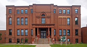
Cass County, Minnesota
 Cass County Courthouse |
|
| administration | |
|---|---|
| US state : | Minnesota |
| Administrative headquarters : | Walker |
| Address of the administrative headquarters: |
County Courthouse 303 Minnesota Avenue Walker, MN 56484-3000 |
| Foundation : | March 31, 1851 |
| Made up from: |
Dakota County Mankahto County Pembina County Wahnata County |
| Area code : | 001 218 |
| Demographics | |
| Residents : | 28,567 (2010) |
| Population density : | 5.5 inhabitants / km 2 |
| geography | |
| Total area : | 6253 km² |
| Water surface : | 1027 km² |
| map | |
The Cass County is a county in the US -amerikanischen State Minnesota . In 2010 , the county had 28,567 residents and a population density of 5.5 people per square kilometer. The county seat is Walker .
Part of the Leech Lake Indian Reservation is in Cass County.
geography
The county is located in north-central Minnesota and has an area of 6253 square kilometers, of which 1027 square kilometers are water.
The largest lake is Leech Lake with an area of 451 square kilometers, which is also the third largest lake in the state of Minnesota. The lake lies entirely in the Chippewa National Forest and is part of the Mississippi river system , which the county meets to the north and the extreme southeast.
The following neighboring counties border Cass County:
| Beltrami County | Itasca County | |
|
Hubbard County , Wadena County |

|
Aitkin County |
| Todd County | Morrison County | Crow Wing County |
history
| Population development | |||
|---|---|---|---|
| Census | Residents | ± in% | |
| 1860 | 150 | - | |
| 1870 | 380 | 153.3% | |
| 1880 | 486 | 27.9% | |
| 1890 | 1247 | 156.6% | |
| 1900 | 7777 | 523.7% | |
| 1910 | 11,620 | 49.4% | |
| 1920 | 15,897 | 36.8% | |
| 1930 | 15,591 | -1.9% | |
| 1940 | 20,646 | 32.4% | |
| 1950 | 19,468 | -5.7% | |
| 1960 | 16,720 | -14.1% | |
| 1970 | 17,323 | 3.6% | |
| 1980 | 21,050 | 21.5% | |
| 1990 | 21,791 | 3.5% | |
| 2000 | 27,150 | 24.6% | |
| 2010 | 28,567 | 5.2% | |
| Before 1900 1900–1990 2000 2010 | |||
Cass County was formed on March 31, 1851 from parts of Walker County and the defunct Mankahto County, Pembina County and Wahnata County. It was named after Lewis Cass (1782–1866), a US military officer, politician and secretary of state .
17 buildings and sites in the county are listed on the National Register of Historic Places (as of January 28, 2018).
Demographic data
As of the 2010 census , Cass County had 28,567 people in 12,943 households. The population density was 5.5 inhabitants per square kilometer. Statistically, 2.17 people lived in each of the 12,943 households.
The racial the population was composed of 86.1 percent white, 0.3 percent African American, 11.0 percent Native American, 0.3 percent Asian and other ethnic groups; 2.2 percent were descended from two or more races. Hispanic or Latino of any race was 1.4 percent of the population.
21.1 percent of the population were under 18 years old, 57.1 percent were between 18 and 64 and 21.8 percent were 65 years or older. 49.1 percent of the population was female.
The median income for a household was 43,042 USD . The per capita income was $ 24,772. 15.1 percent of the population lived below the poverty line.
Cass County localities
Other Unincorporated Communities
1 - predominantly in Morrison County
structure
In addition to the 15 cities, Cass County is divided into 50 townships (TS) and four unorganized territories (UT):
|
|
|
|
See also
Individual evidence
- ↑ GNIS-ID: 659456. Retrieved on February 22, 2011 (English).
- ↑ a b c U.S. Census Bureau, State & County QuickFacts - Cass County, MN Retrieved April 8, 2013
- ^ A b National Association of Counties.Retrieved April 8, 2013
- ^ US Census Bureau _ Census of Population and Housing.Retrieved February 17, 2011
- ↑ Extract from Census.gov.Retrieved February 17, 2011
- ↑ Search mask database in the National Register Information System. National Park Service , accessed January 28, 2018.
- ^ Census 2010 - Minnesota , Retrieved May 5, 2020
Web links
Coordinates: 46 ° 57 ′ N , 94 ° 19 ′ W


