
Clearwater County, Minnesota
.jpg) Clearwater County Courthouse |
|
| administration | |
|---|---|
| US state : | Minnesota |
| Administrative headquarters : | Bagley |
| Address of the administrative headquarters: |
County Courthouse 213 Main Avenue N. Bagley, MN 56621-8310 |
| Foundation : | December 20, 1902 |
| Made up from: | Beltrami County |
| Area code : | 001 218 |
| Demographics | |
| Residents : | 8695 (2010) |
| Population density : | 3.4 inhabitants / km 2 |
| geography | |
| Total area : | 2667 km² |
| Water surface : | 91 km² |
| map | |
 |
|
| Website : www.co.clearwater.mn.us | |

The Clearwater County is a county in the US -amerikanischen State Minnesota . In 2010 , the county had 8,695 people and a population density of 3.4 people per square kilometer. The county seat is Bagley , named after Sumner Bagley , a lumberjack.
With the Red Lake Reservation and the White Earth Indian Reservation two extend Indian reservations in part in the Clearwater County.
geography
The county is located in central northwest Minnesota and has an area of 2,667 square kilometers, of which 91 square kilometers are water.
In the southeast of the county is the Itasca State Park , in which Lake Itasca is the source lake of the Mississippi, which initially flows in a northeastern direction . On the northeast county boundary is Red Lake , which is drained by the Red Lake River , which flows through the county to the north . It is a right tributary of the Red River of the North , which belongs to the basin of the Nelson River , which drains into Hudson Bay . Between the two rivers is the watershed between the Gulf of Mexico and the Arctic Ocean .

Entrance to Itasca State Park

Eastern entrance of Itasca State Park

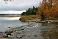
On the shores of Lake Itasca
The Mississippi in Itasca State Park


The following neighboring counties border Clearwater County:
| Pennington County | Beltrami County | |
| Polk County |
.svg)
|
|
| Mahnomen County | Becker County | Hubbard County |
history
| Population development | |||
|---|---|---|---|
| Census | Residents | ± in% | |
| 1910 | 6870 | - | |
| 1920 | 8569 | 24.7% | |
| 1930 | 9546 | 11.4% | |
| 1940 | 11,153 | 16.8% | |
| 1950 | 10.204 | -8.5% | |
| 1960 | 8864 | -13.1% | |
| 1970 | 8013 | -9.6% | |
| 1980 | 8761 | 9.3% | |
| 1990 | 8309 | -5.2% | |
| 2000 | 8423 | 1.4% | |
| 2010 | 8695 | 3.2% | |
| 1900–1990 2000 2010 | |||
Clearwater County was formed on December 20, 1902 from parts of Beltrami County. It was named after the Clearwater River and Clearwater Lake, both of which are located within the county.
Five places in the county are listed on the National Register of Historic Places as of January 28, 2018.
Demographic data
As of the 2010 census , Clearwater County had 8,695 people in 3,684 households. The population density was 3.4 inhabitants per square kilometer. Statistically, 2.31 people lived in 3684 households.
The racial the population was composed of 87.3 percent white, 0.5 percent African American, 9.0 percent Native American, 0.3 percent Asian and other ethnic groups; 2.9 percent were descended from two or more races. Regardless of ethnicity, 1.5 percent of the population was Hispanic or Latino of any race.
24.5 percent of the population were under 18 years old, 56.6 percent were between 18 and 64 and 18.9 percent were 65 years or older. 49.8 percent of the population was female.
The median income for a household was 39,143 USD . The per capita income was $ 21,466. 16.2 percent of the population lived below the poverty line.
Clearwater County localities
Census-designated places (CDP)
Other Unincorporated Communities
1 - partly in Becker County
2 - partly in Mahnomen County
structure
In addition to the five cities, Clearwater County is divided into 22 townships and two unorganized territories (UT):
|
|
|
See also
Individual evidence
- ↑ GNIS-ID: 659460. Retrieved on February 22, 2011 (English).
- ↑ a b c U.S. Census Bureau, State & County QuickFacts - Clearwater County, MN Retrieved April 15, 2013
- ^ A b National Association of Counties.Retrieved April 15, 2013
- ↑ Extract from Census.gov.Retrieved February 17, 2011
- ↑ Search mask database in the National Register Information System. National Park Service , accessed January 28, 2018.
- ^ Census 2010 - Minnesota , Retrieved May 5, 2020
Web links
List of counties in Minnesota
Aitkin |
Anoka |
Becker |
Beltrami |
Benton |
Big Stone |
Blue Earth |
Brown |
Carlton |
Carver |
Cass |
Chippewa |
Chisago |
Clay |
Clearwater |
Cook |
Cottonwood |
Crow Wing |
Dakota |
Dodge |
Douglas |
Faribault |
Fillmore |
Freeborn |
Goodhue |
Grant |
Hennepin |
Houston |
Hubbard |
Isanti |
Itasca |
Jackson |
Kanabec |
Kandiyohi |
Kittson |
Koochiching |
Lac qui Parle |
Lake |
Lake of the Woods |
Le Sueur |
Lincoln |
Lyon |
Reminders |
Marshall |
Martin |
McLeod |
Meeker |
Mille Lacs |
Morrison |
Mower |
Murray |
Nicollet |
Nobles |
Norman |
Olmsted |
Otter Tail |
Pennington |
Pine |
Pipestone |
Polk |
Pope |
Ramsey |
Red Lake |
Redwood |
Renville |
Rice |
Skirt |
Roseau |
Scott |
Sherburne |
Sibley |
St. Louis |
Stearns |
Steele |
Stevens |
Swift |
Todd |
Traverse |
Wabasha |
Wadena |
Waseca |
Washington |
Watonwan |
Wilkin |
Winona |
Wright |
Yellow Medicine
Coordinates: 47 ° 34 ' N , 95 ° 23' W