
Red Lake River
| Red Lake River | ||
 |
||
| Data | ||
| Water code | US : 649867 | |
| location | Minnesota | |
| River system | Nelson River | |
| Drain over | Red River of the North → Nelson River → Hudson Bay | |
| source |
Red Lake 47 ° 57 ′ 35 ″ N , 95 ° 16 ′ 28 ″ W. |
|
| muzzle | In East Grand Forks in the Red River of the North Coordinates: 47 ° 55 '21 " N , 97 ° 1' 17" W 47 ° 55 '21 " N , 97 ° 1' 17" W. |
|
| Mouth height |
243 m
|
|
| length | 310.6 km | |
The Red Lake River forms the outlet of the Red Lake and flows west through the Clearwater , Pennington , Red Lake and Polk Counties . It flows through the cities of Thief River Falls , Red Lake Falls and Crookston before the river forks in two parts around 20 km southwest of East Grand Forks . The southern part flows through the city and flows into the Red River of the North across from Grand Forks in South Dakota . The northern arm flows northeast of the city and flows around 15 km to the north.

Crookston
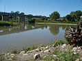
Mouth of the southern arm at East Grand Forks


Individual evidence
- ↑ USGS - Red Lake River. Retrieved April 15, 2013
- ↑ USGS The National Map Viewer.Retrieved April 15, 2013