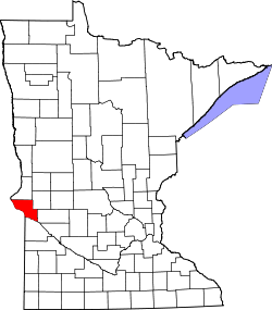
Big Stone County
 Big Stone County Courthouse |
|
| administration | |
|---|---|
| US state : | Minnesota |
| Administrative headquarters : | Ortonville |
| Address of the administrative headquarters: |
County Courthouse 20 SE 2nd Street Ortonville, MN 56278-1544 |
| Foundation : | February 20, 1862 |
| Made up from: | Pierce County |
| Area code : | 001 320 |
| Demographics | |
| Residents : | 5269 (2010) |
| Population density : | 4.1 inhabitants / km 2 |
| geography | |
| Total area : | 1367 km² |
| Water surface : | 80 km² |
| map | |
| Website : www.bigstonecounty.org | |
The Big Stone County is a county in the US -amerikanischen State Minnesota . In 2010 , the county had 5,269 people and a population density of 4.1 people per square kilometer. The county seat is Ortonville , which was named after its founder Cornelius Knute Orton .
geography
The county is in western Minnesota. It has an area of 1367 square kilometers, of which 80 square kilometers are water.
The county is located on the northeastern shore of Big Stone Lake , which forms the border with South Dakota . The outflow of the lake is the Minnesota River , which borders the county to the southwest. In the extreme northwest is the Traverse Gap , the watershed between the Atlantic and the Arctic Ocean .
The following neighboring counties border Big Stone County:
|
Roberts County, South Dakota |
Traverse County | Stevens County |

|
||
|
Grant County, South Dakota |
Lac qui Parle County | Swift County |
history
| Population development | |||
|---|---|---|---|
| Census | Residents | ± in% | |
| 1870 | 24 | - | |
| 1880 | 3688 | 15,266.7% | |
| 1890 | 5722 | 55.2% | |
| 1900 | 8731 | 52.6% | |
| 1910 | 9367 | 7.3% | |
| 1920 | 9766 | 4.3% | |
| 1930 | 9838 | 0.7% | |
| 1940 | 10,447 | 6.2% | |
| 1950 | 9607 | -8th % | |
| 1960 | 8954 | -6.8% | |
| 1970 | 7941 | -11.3% | |
| 1980 | 7716 | -2.8% | |
| 1990 | 6285 | -18.5% | |
| 2000 | 5820 | -7.4% | |
| 2010 | 5269 | -9.5% | |
| Before 1900 1900–1990 2000 2010 | |||
Big Stone County was formed on February 20, 1862 from Pierce County, which now only exists in Wisconsin. It was named after the Big Stone Lake.
Nine structures and sites in the county are listed on the National Register of Historic Places (as of January 28, 2018).
Big Stone County localities
According to the 2010 census , Big Stone County had 5,269 people in 2,395 households. The population density was 4.1 inhabitants per square kilometer. Statistically, 2.15 people lived in each of the 2395 households.
The racial the population was composed of 98.3 percent white, 0.3 percent African American, 0.5 percent Native American, 0.1 percent Asian and other ethnic groups; 0.9 percent were descended from two or more races. Hispanic or Latino of any race was 0.9 percent of the population.
20.9 percent of the population were under 18 years old, 53.8 percent were between 18 and 64 and 25.3 percent were 65 years or older. 51.3 percent of the population was female.
The median income for a household was 44,438 USD . The per capita income was $ 24,960. 11.2 percent of the population lived below the poverty line.
All localities have the municipal status of City .
1 - partly in Lac qui Parle County
structure
Big Stone County is divided into 14 townships :
|
|
The cities of Barry , Clinton , Correll , Graceville and Odessa do not belong to any township.
See also
Individual evidence
- ↑ GNIS-ID: 659451. Retrieved on February 22, 2011 (English).
- ↑ a b c U.S. Census Bureau, State & County QuickFacts - Big Stone County, MN. Retrieved March 30, 2013
- ↑ a b National Association of Counties.Retrieved March 30, 2013
- ^ US Census Bureau - Census of Population and Housing.Retrieved March 15, 2011
- ^ Extract from Census.gov.Retrieved February 18, 2011
- ↑ Search mask database in the National Register Information System. National Park Service , accessed January 28, 2018.
- ^ Census 2010 - Minnesota , Retrieved May 5, 2020
Web links
Coordinates: 45 ° 26 ' N , 96 ° 24' W

