Murray County, Minnesota
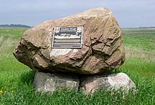
 Murray County Government Center |
|
| administration | |
|---|---|
| US state : | Minnesota |
| Administrative headquarters : | Slayton |
| Address of the administrative headquarters: |
County Courthouse 2500 28th Street Slayton, MN 56172-1493 |
| Foundation : | May 23, 1857 |
| Made up from: | Brown County |
| Area code : | 001 507 |
| Demographics | |
| Residents : | 8725 (2010) |
| Population density : | 4.8 inhabitants / km 2 |
| geography | |
| Total area : | 1864 km² |
| Water surface : | 39 km² |
| map | |
| Website : www.murray-countymn.com | |
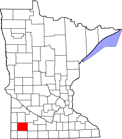
The Murray County is a county in the US -amerikanischen State Minnesota . In 2010 , the county had 8,725 people and a population density of 4.8 people per square kilometer. The county seat is Slayton .
geography
The county is located in southwest Minnesota, about 35 km to the west from South Dakota and about 40 km to the south from Iowa . It has an area of 1864 square kilometers, of which 39 square kilometers are water. The following neighboring counties border Murray County:
| Lyon County | Redwood County | |
| Pipestone County |

|
Cottonwood County |
| Rock county | Nobles County |
history
Murray County was formed on May 23, 1857 from parts of Brown County. It was named after William Pitt Murray (1825-1910), Member of the Minnesota - Territory (1852-1855 and 1857).
Demographic data
| Population development | |||
|---|---|---|---|
| Census | Residents | ± in% | |
| 1860 | 29 | - | |
| 1870 | 200 | 589.7% | |
| 1880 | 3604 | 1,702% | |
| 1890 | 6692 | 85.7% | |
| 1900 | 11,911 | 78% | |
| 1910 | 11,755 | -1.3% | |
| 1920 | 13,631 | 16% | |
| 1930 | 13,902 | 2% | |
| 1940 | 15,060 | 8.3% | |
| 1950 | 14,801 | -1.7% | |
| 1960 | 14,743 | -0.4% | |
| 1970 | 12,508 | -15.2% | |
| 1980 | 11,507 | -8th % | |
| 1990 | 9660 | -16.1% | |
| 2000 | 9165 | -5.1% | |
| 2010 | 8725 | -4.8% | |
| Before 1900 1900–1990 2000 2010 | |||
As of the 2010 census , Murray Counties had 8,725 people in 3,914 households. The population density was 4.8 inhabitants per square kilometer. Statistically, 2.19 people lived in each of the 3,914 households.
The racial the population was composed of 97.5 percent white, 0.3 percent African American, 0.2 percent Native American, 1.0 percent Asian and other ethnic groups; 0.9 percent were descended from two or more races. Hispanic or Latino of any race was 2.9 percent of the population.
21.9 percent of the population were under 18 years old, 55.5 percent were between 18 and 64 and 22.6 percent were 65 years or older. 50.4 percent of the population was female.
The median income for a household was 47,833 USD . The per capita income was $ 25,344. 9.9 percent of the population lived below the poverty line.
Murray County localities
structure
In addition to the nine cities, Murray County is divided into 20 townships :
|
|
See also
Individual evidence
- ↑ GNIS-ID: 659496. Retrieved on February 22, 2011 (English).
- ↑ a b c U.S. Census Bureau, State & County QuickFacts - Murray County, MN ( July 15, 2011 memento on WebCite ) Retrieved May 28, 2013
- ↑ a b National Association of Counties.Retrieved May 28, 2013
- ^ US Census Bureau - Census of Population and Housing.Retrieved March 15, 2011
- ^ Extract from Census.gov.Retrieved February 18, 2011
- ^ Census 2010 - Minnesota , Retrieved May 5, 2020
Web links
Coordinates: 44 ° 1 ′ N , 95 ° 46 ′ W


