Nicollet County
![The Nicollet County Courthouse and Jail in Saint Peter, listed in the NRHP since 2002 [1]](https://upload.wikimedia.org/wikipedia/commons/thumb/1/15/Nicollet_County_Courthouse.jpg/298px-Nicollet_County_Courthouse.jpg) The Nicollet County Courthouse and Jail in Saint Peter, listed on the NRHP since 2002 |
|
| administration | |
|---|---|
| US state : | Minnesota |
| Administrative headquarters : | St. Peter |
| Address of the administrative headquarters: |
County Courthouse 501 South Minnesota Avenue Saint Peter, MN 56082-2543 |
| Foundation : | March 5, 1853 |
| Made up from: | Dakota County |
| Area code : | 001 507 |
| Demographics | |
| Residents : | 32,727 (2010) |
| Population density : | 27.9 inhabitants / km 2 |
| geography | |
| Total area : | 1209 km² |
| Water surface : | 38 km² |
| map | |
| Website : www.co.nicollet.mn.us | |
The Nicollet County is a county in the US -amerikanischen State Minnesota . In 2010 , the county had 32,727 residents and a population density of 27.9 people per square kilometer. The county seat is St. Peter .
geography
The county is located in south central Minnesota on the north bank of the Minnesota River . It has an area of 1209 square kilometers, of which 38 square kilometers are water. The following neighboring counties border Nicollet County:
| Renville County | Sibley County | |

|
Le Sueur County | |
| Brown County | Blue Earth County |
history
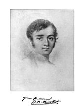
Nicollet County was formed on March 5, 1853 from parts of Dakota County. It was named after Joseph Nicolas Nicollet (1786–1843), a French geographer and mathematician who mapped the upper reaches of the Mississippi around 1830 .
24 buildings and sites in the county are listed on the National Register of Historic Places (as of January 31, 2018).
Demographic data
| Population development | |||
|---|---|---|---|
| Census | Residents | ± in% | |
| 1860 | 3773 | - | |
| 1870 | 8362 | 121.6% | |
| 1880 | 12,333 | 47.5% | |
| 1890 | 13,382 | 8.5% | |
| 1900 | 14,774 | 10.4% | |
| 1910 | 14,125 | -4.4% | |
| 1920 | 15,036 | 6.4% | |
| 1930 | 16,550 | 10.1% | |
| 1940 | 18,282 | 10.5% | |
| 1950 | 20,929 | 14.5% | |
| 1960 | 23,196 | 10.8% | |
| 1970 | 24,518 | 5.7% | |
| 1980 | 26,929 | 9.8% | |
| 1990 | 28,076 | 4.3% | |
| 2000 | 29,771 | 6% | |
| 2010 | 32,727 | 9.9% | |
| Before 1900 1900–1990 2000 2010 | |||

As of the 2010 census , Nicollet County had 32,727 people in 12,247 households. The population density was 27.9 inhabitants per square kilometer. Statistically, 2.46 people lived in each of the 12,247 households.
The racial the population was composed of 94.5 percent white, 2.3 percent African American, 0.5 percent Native American, 1.5 percent Asian and other ethnic groups; 1.3 percent were descended from two or more races. Regardless of ethnicity, 3.8 percent of the population was Hispanic or Latino of any race.
22.1 percent of the population were under 18 years old, 65.7 percent were between 18 and 64 and 12.2 percent were 65 years or older. 50.2 percent of the population was female.
The median income for a household was 59,877 USD . The per capita income was $ 26,108. 11.3 percent of the population lived below the poverty line.
Localities in Nicollet County
1 - predominantly in Blue Earth County
structure
In addition to the seven cities, Nicollet County is divided into 13 townships :
|
|
See also
Individual evidence
- ↑ Extract from the National Register of Historic Places - No. 02000939.Retrieved August 23, 2011
- ↑ GNIS-ID: 659497. Retrieved on February 22, 2011 (English).
- ↑ a b c U.S. Census Bureau, State & County QuickFacts - Nicollet County, MN ( July 15, 2011 memento on WebCite ) Retrieved at HH
- ^ A b National Association of Counties.Retrieved March 6, 2013
- ↑ Search mask database in the National Register Information System. National Park Service , accessed January 31, 2018.
- ^ US Census Bureau _ Census of Population and Housing.Retrieved February 17, 2011
- ↑ Extract from Census.gov.Retrieved February 17, 2011
- ^ Census 2010 - Minnesota , Retrieved May 5, 2020
Web links
Coordinates: 44 ° 20 ′ N , 94 ° 15 ′ W

