
Wadena County
| administration | |
|---|---|
| US state : | Minnesota |
| Administrative headquarters : | Wadena |
| Address of the administrative headquarters: |
County Courthouse 415 South Jefferson Street Wadena, MN 56482-1596 |
| Foundation : | June 11, 1858 |
| Made up from: |
Cass County Todd County |
| Area code : | 001 218 |
| Demographics | |
| Residents : | 13,843 (2010) |
| Population density : | 10 inhabitants / km 2 |
| geography | |
| Total area : | 1406 km² |
| Water surface : | 21 km² |
| map | |
 |
|
| Website : www.co.wadena.mn.us | |
The Wadena County is a county in the US -amerikanischen State Minnesota . In 2010 , the county had 13,843 residents and a population density of 10 people per square kilometer. The county seat is Wadena .
geography
The county is located just northwest of the geographic center of Minnesota. It has an area of 1406 square kilometers, of which 21 square kilometers are water.
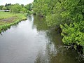
The largest river is the Crow Wing River , which flows through the west of the county from north to south and flows further east from the right into the upper Mississippi . In the southwest of the county, the Leaf River flows into the Crow Wing River from the right. The north of the county is from west to east of the Shell River , until it also flows into the Crow Wing River.
The following neighboring counties border Wadena County:
| Becker County | Hubbard County | |
.svg)
|
Cass County | |
| Otter Tail County | Todd County |

The Blueberry River
The Redeye River

Wadena Fire and City Hall , listed on the NRHP


| Population development | |||
|---|---|---|---|
| Census | Residents | ± in% | |
| 1870 | 6th | - | |
| 1880 | 2080 | 34,566.7% | |
| 1890 | 4053 | 94.9% | |
| 1900 | 7921 | 95.4% | |
| 1910 | 8652 | 9.2% | |
| 1920 | 10,699 | 23.7% | |
| 1930 | 10,990 | 2.7% | |
| 1940 | 12,772 | 16.2% | |
| 1950 | 12,806 | 0.3% | |
| 1960 | 12.199 | -4.7% | |
| 1970 | 12,412 | 1.7% | |
| 1980 | 14,192 | 14.3% | |
| 1990 | 13,154 | -7.3% | |
| 2000 | 13,713 | 4.2% | |
| 2010 | 13,843 | 0.9% | |
| Before 1900 1900–1990 2000 2010 | |||
history
Wadena County was formed on June 11, 1858 from parts of Cass County and Todd County. It was named after the Wadena Trading Post that was built within the county on the Crow Wing-to-Pembina Trail .
Demographic data
According to the 2010 census , Wadena County had 13,843 people in 5,968 households. The population density was 10 people per square kilometer. Statistically, 2.26 people lived in each of the 5968 households.
The racial the population was composed of 96.7 percent white, 0.9 percent African American, 0.6 percent Native American, 0.3 percent Asian and other ethnic groups; 1.5 percent were descended from two or more races. Hispanic or Latino of any race was 1.3 percent of the population, regardless of ethnicity.
23.7 percent of the population were under 18 years old, 54.8 percent were between 18 and 64 and 21.5 percent were 65 years or older. 50.7 percent of the population was female.
The median income for a household was 35,307 USD . The per capita income was $ 19,812. 18.0 percent of the population lived below the poverty line.
Localities in Wadena County
1 - partly in Todd County
2 - partly in Otter Tail County
structure
In addition to the seven cities, Wadena County is divided into 15 townships :
|
|
See also
Individual evidence
- ↑ GNIS-ID: 659524. Retrieved on February 22, 2011 (English).
- ↑ a b c U.S. Census Bureau, State & County QuickFacts - Wadena County, MN ( September 19, 2013 memento on the Internet Archive ). Retrieved July 1, 2013
- ↑ a b National Association of Counties.Retrieved July 1, 2013
- ^ US Census Bureau - Census of Population and Housing.Retrieved March 15, 2011
- ^ Extract from Census.gov.Retrieved February 18, 2011
- ^ Census 2010 - Minnesota , Retrieved May 5, 2020
Web links
List of counties in Minnesota
Aitkin |
Anoka |
Becker |
Beltrami |
Benton |
Big Stone |
Blue Earth |
Brown |
Carlton |
Carver |
Cass |
Chippewa |
Chisago |
Clay |
Clearwater |
Cook |
Cottonwood |
Crow Wing |
Dakota |
Dodge |
Douglas |
Faribault |
Fillmore |
Freeborn |
Goodhue |
Grant |
Hennepin |
Houston |
Hubbard |
Isanti |
Itasca |
Jackson |
Kanabec |
Kandiyohi |
Kittson |
Koochiching |
Lac qui Parle |
Lake |
Lake of the Woods |
Le Sueur |
Lincoln |
Lyon |
Reminders |
Marshall |
Martin |
McLeod |
Meeker |
Mille Lacs |
Morrison |
Mower |
Murray |
Nicollet |
Nobles |
Norman |
Olmsted |
Otter Tail |
Pennington |
Pine |
Pipestone |
Polk |
Pope |
Ramsey |
Red Lake |
Redwood |
Renville |
Rice |
Skirt |
Roseau |
Scott |
Sherburne |
Sibley |
St. Louis |
Stearns |
Steele |
Stevens |
Swift |
Todd |
Traverse |
Wabasha |
Wadena |
Waseca |
Washington |
Watonwan |
Wilkin |
Winona |
Wright |
Yellow Medicine
Coordinates: 46 ° 35 ′ N , 94 ° 58 ′ W