Nimrod, Minnesota
| Nimrod | |
|---|---|
 Entrance |
|
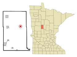
| Location of Nimrod in Wadena County | |
| Basic data | |
| Foundation : | August 20, 1924 |
| State : | United States |
| State : | Minnesota |
| County : | Wadena County |
| Coordinates : | 46 ° 38 ′ N , 94 ° 53 ′ W |
| Time zone : | Central ( UTC − 6 / −5 ) |
| Residents : | 69 (as of 2010) |
| Population density : | 28.3 inhabitants per km 2 |
| Area : | 2.58 km 2 (approx. 1 mi 2 ) of which 2.44 km 2 (approx. 1 mi 2 ) is land |
| Height : | 404 m |
| Postal code : | 56477 |
| Area code : | +1 218 |
| FIPS : | 27-46294 |
| GNIS ID : | 0648556 |
| Mayor : | Keith Frame |
Nimrod is a small town ( city ) in Wadena County in the state of Minnesota in the United States . At the last census in 2010 , Nimrod had 69 inhabitants.
location
Nimrod is located in central Minnesota, around 16 kilometers east of Sebeka , 130 kilometers northwest of St. Cloud and 150 kilometers east-southeast of Fargo . The Huntersville State Forest is located near the village . The Crow Wing River , a tributary of the Mississippi River, flows through the village .
history
The settlement of Nimrod was created as a stopover for wheat traders who brought their wheat from Shell City to the nearest train station in Verndale . The place was named after the biblical figure Nimrod . In 1887 a post office was opened in the village, which was closed again in 1917. On August 20, 1924, Nimrod was incorporated as a Village . In 1938 the village received a post office again and on December 4, 1946, Nimrod was elevated to the status of a city.
The post office in Nimrod is still in operation today. The city administration is now in Sebeka. The Nimrod Jubilee Days festival has been held in Nimrod every year on the weekend before Labor Day since 1979 .
population
| growth of population | |||
|---|---|---|---|
| Census | Residents | ± in% | |
| 1950 | 112 | - | |
| 1960 | 60 | -46.4% | |
| 1970 | 64 | 6.7% | |
| 1980 | 69 | 7.8% | |
| 1990 | 65 | -5.8% | |
| 2000 | 75 | 15.4% | |
| 2010 | 69 | -8th % | |
| US Decennial Census | |||
2010 Census
In the United States Census 2010, Nimrod had 69 residents, who were distributed among 34 households and 19 families. 100% of the population were white . There were married couples in 44.1% of the households in Verndale, 8.8% of the households were made up of single women and 2.9% of single men. 14.7% of the households had children under the age of 18 living with them and 14.7% of the households had seniors over 65 years of age.
The median age in Nimrod in 2010 was 51.8 years. 15.9% of the residents were under 18 years old, 5.8% were between 18 and 24, 20.2% between 25 and 44, 33.2% between 45 and 65 and 24.6% of the residents were older than 65 Years. 39.1% of the population were male and 60.9% female.
Census 2000
In the United States Census 2000 , Nimrod had 75 residents in 35 households and 17 families. All were white, of which 25.0% were each of American and German descent, 14.3% of Norwegian descent, and 11.9% of Irish descent.
At the time of the census, the median income in Nimrod was $ 30,313 per household and $ 46,250 per family. The average per capita income was $ 15,413. 6.8% of the population of Nimrod lived below the poverty line , of which none were under 18 and 11.8% over 65 years old.
Infrastructure
Nimrod is at the eastern end of Minnesota State Highway 227 , which connects the place with the city of Sebeka. US Highway 71 is located approximately 17 kilometers west of Nimrod between Park Rapids and Wadena .
Web links
Individual evidence
- ↑ a b A Guide to Minnesota Communities. In: lakesnwoods.com , accessed October 10, 2019.
- ^ Post Offices in Wadena County. In: postalhistory.com , accessed October 10, 2019.
- ^ Profile of General Population and Housing Characteristics. United States Census Bureau, accessed October 10, 2019.
