Redeye River
| Redeye River | ||
|
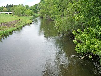
The Redeye River in Sebeka (2007) |
||
| Data | ||
| location | Minnesota (USA) | |
| River system | Mississippi River | |
| Drain over | Leaf River → Crow Wing River → Mississippi River → Gulf of Mexico | |
| source |
Wolf Lake , Toad Lake Township , Becker County 46 ° 49′17 ″ N , 95 ° 25′6 ″ W. |
|
| Source height | 467 m | |
| muzzle |
Leaf River , Bullard Township , Wadena County Coordinates: 46 ° 29 ′ 10 " N , 94 ° 53 ′ 6" W 46 ° 29 ′ 10 " N , 94 ° 53 ′ 6" W |
|
| Mouth height | 385 m | |
| Height difference | 82 m | |
| Bottom slope | 0.7 ‰ | |
| length | 117 km | |
| Catchment area | 575 km² | |
The Redeye River is a 117 km long tributary of the Leaf River in central Minnesota , United States . About the Leaf River and Crow Wing River it is part of the catchment area of the Mississippi River and drains an area of 575 km² in a rural region.
geography
The Redeye River has its origin in a moraine region in Wolf Lake in Toad Lake Township in southeast Becker County and flows generally southeast through northeast Otter Tail County and the middle of Wadena County . It flows through the city of Sebeka and flows into the Bullard Township in the southeast of Wadena County in the Leaf River, 13 km above the mouth of this river in the Crow Wing River. The course of the river lies within the North Central Hardwood Forest ecoregion , which is characterized by mixed forests with hardwood plants such as maple and linden as well as coniferous plants on sand surfaces and the moraine bottom of a dry glacial lake .
See also
Individual evidence
- ^ Redeye River in the Geographic Names Information System of the United States Geological Survey
- ^ A b C. A. Sanocki, BC Fischer: Physical Characteristics of Stream Subbasins in the Redeye (Leaf) River Basin, Central Minnesota . United States Geological Survey . 2000. Archived from the original on September 25, 2006. Retrieved June 17, 2007.
- ^ Thomas F. Waters: The Crow Wing: Oxcart to Canoe . In: The Streams and Rivers of Minnesota . University of Minnesota Press , Minneapolis 2006, ISBN 0-8166-0960-8 , pp. 184-194.
- ^ Minnesota Atlas & Gazetteer . DeLorme , Yarmouth, Me. 1994, ISBN 0-89933-222-6 , pp. 53, 60-61.
- ^ Upper Mississippi River Basin. . Minnesota Pollution Control Agency. S. Upper Mississippi River Basin Water Quality Plan, Headwaters to the Rum River - Anoka, Section III: Upper Mississippi River Basin . 2000. Archived from the original on June 18, 2007. Info: The archive link was inserted automatically and has not yet been checked. Please check the original and archive link according to the instructions and then remove this notice. Retrieved June 17, 2007.
