
Stearns County
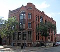
![Stearns County Courthouse, listed on NRHP No. 82003056 [1]](https://de.wikipedia.org/wiki/Datei:Stearns_Co_Courthouse_1.jpg) Stearns County Courthouse, listed on NRHP No. 82003056 |
|
| administration | |
|---|---|
| US state : | Minnesota |
| Administrative headquarters : | St. Cloud |
| Address of the administrative headquarters: |
County Courthouse 705 Courthouse Square Saint Cloud, MN 56303-4781 |
| Foundation : | February 20, 1855 |
| Made up from: |
Cass County Nicollet County Pierce County Sibley County |
| Area code : | 001 320 |
| Demographics | |
| Residents : | 150,642 (2010) |
| Population density : | 43.3 inhabitants / km 2 |
| geography | |
| Total area : | 3600 km² |
| Water surface : | 118 km² |
| map | |
 |
|
| Website : www.co.stearns.mn.us | |
The Stearns County is a county in the US -amerikanischen State Minnesota . In 2010 , the county had 150,642 residents and a population density of 43.3 people per square kilometer. The county seat is St. Cloud .
geography
The county is located just south of the geographic center of Minnesota at the confluence of the Sauk River in the upper Mississippi . It has an area of 3600 square kilometers, of which 118 square kilometers are water. The following neighboring counties border Stearns County:
| Douglas County |
Todd County , Morrison County |
Benton County |
| Pope County |
.svg)
|
Sherburne County |
|
Kandiyohi County , Meeker County |
Wright County |
history
The Stearns County was formed on February 20, 1855 from parts of Cass County, Nicollet County, Sibley County and Pierce County , which now only exists in Wisconsin . It was named after Charles Thomas Stearns , a member of the Minnesota Territorial Administration from 1849 to 1858.
Historical objects

Church of St. Boniface in Melrose

Nehemiah P. Clarke House in St. Cloud
First National Bank in St. Cloud
.jpg)


One place in Stearns County has the status of a National Historic Landmark , the Sinclair Lewis Boyhood Home .
Other historical objects:
Demographic data
| Population development | |||
|---|---|---|---|
| Census | Residents | ± in% | |
| 1860 | 4505 | - | |
| 1870 | 14.206 | 215.3% | |
| 1880 | 21,056 | 48.2% | |
| 1890 | 34,844 | 65.5% | |
| 1940 | 67,200 | - | |
| 1950 | 70,681 | 5.2% | |
| 1960 | 80,345 | 13.7% | |
| 1970 | 95,400 | 18.7% | |
| 1980 | 108.161 | 13.4% | |
| 1990 | 118,791 | 9.8% | |
| 2000 | 133.166 | 12.1% | |
| 2010 | 150,642 | 13.1% | |
| Before 1900 1900–1990 2000 2010 | |||
According to the 2010 census , Stearns County had 150,642 people in 56,469 households. The population density was 43.3 inhabitants per square kilometer. Statistically, 2.49 people lived in each of the 56,469 households.
The racial the population was composed of 92.7 percent white, 3.2 percent African American, 0.4 percent Native American, 2.1 percent Asian, 0.1 percent Polynesian and other ethnic groups; 1.4 percent were descended from two or more races. Hispanic or Latino of any race was 2.9 percent of the population.
22.7 percent of the population were under 18 years old, 64.9 percent were between 18 and 64 and 12.4 percent were 65 years or older. 49.5 percent of the population was female.
The median income for a household was 53,035 USD . The per capita income was $ 25,329. 12.8 percent of the population lived below the poverty line.
Stearns County localities
1 - partly in Pope County
2 - partly in Wright County
3 - partly in Meeker County
4 - partly in Benton County
5 - partly in Benton and Sherburne County
structure
In addition to the 31 cities, Stearns County is divided into 34 townships :
Individual evidence
- ^ Extract from the National Register of Historic Places.Retrieved March 13, 2011
- ↑ GNIS-ID: 659517. Retrieved on February 22, 2011 (English).
- ↑ a b c U.S. Census Bureau, State & County QuickFacts - Stearns County, MN Retrieved March 1, 2013
- ^ A b National Association of Counties.Retrieved March 1, 2013
- ↑ Listing of National Historic Landmarks by State: Minnesota . National Park Service , accessed January 31, 2018.
- ^ US Census Bureau - Census of Population and Housing.Retrieved March 15, 2011
- ↑ Extract from Census.gov.Retrieved February 17, 2011
- ^ Census 2010 - Minnesota , Retrieved May 5, 2020
Web links
List of counties in Minnesota
Aitkin |
Anoka |
Becker |
Beltrami |
Benton |
Big Stone |
Blue Earth |
Brown |
Carlton |
Carver |
Cass |
Chippewa |
Chisago |
Clay |
Clearwater |
Cook |
Cottonwood |
Crow Wing |
Dakota |
Dodge |
Douglas |
Faribault |
Fillmore |
Freeborn |
Goodhue |
Grant |
Hennepin |
Houston |
Hubbard |
Isanti |
Itasca |
Jackson |
Kanabec |
Kandiyohi |
Kittson |
Koochiching |
Lac qui Parle |
Lake |
Lake of the Woods |
Le Sueur |
Lincoln |
Lyon |
Reminders |
Marshall |
Martin |
McLeod |
Meeker |
Mille Lacs |
Morrison |
Mower |
Murray |
Nicollet |
Nobles |
Norman |
Olmsted |
Otter Tail |
Pennington |
Pine |
Pipestone |
Polk |
Pope |
Ramsey |
Red Lake |
Redwood |
Renville |
Rice |
Skirt |
Roseau |
Scott |
Sherburne |
Sibley |
St. Louis |
Stearns |
Steele |
Stevens |
Swift |
Todd |
Traverse |
Wabasha |
Wadena |
Waseca |
Washington |
Watonwan |
Wilkin |
Winona |
Wright |
Yellow Medicine
Coordinates: 45 ° 33 ′ N , 94 ° 37 ′ W