Sartell
| Sartell | |
|---|---|
 |
|
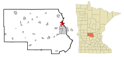
| Location in Minnesota | |
| Basic data | |
| Foundation : | 1907 |
| State : | United States |
| State : | Minnesota |
| Counties : |
Stearns County Benton County |
| Coordinates : | 45 ° 19 ′ N , 93 ° 59 ′ W |
| Time zone : | Central ( UTC − 6 / −5 ) |
| Residents : | 15,876 (as of 2010) |
| Population density : | 625.5 inhabitants per km 2 |
| Area : | 26.03 km 2 (approx. 10 mi 2 ) of which 25.38 km 2 (approx. 10 mi 2 ) are land |
| Height : | 302 m |
| Postal code : | 56377 |
| Area code : | +1 320 |
| FIPS : | 27-58612 |
| GNIS ID : | 652026 |
| Website : | www.sartellmn.com |
| Mayor : | Joe Perske |
Sartell is a city (with the status " City ") in Stearns County and to a lesser extent in Benton County in the center of the US -amerikanischen state of Minnesota . In 2010 , Sartell had 15,876 residents.
geography
Sartell lies on both sides of the Mississippi above the confluence of the Sauk River at 45 ° 18'54 "north latitude and 93 ° 58'47" west longitude. The city extends over 26.03 km², which is spread over 25.38 km² of land and 0.65 km² of water.
Neighboring towns of Sartell are St. Cloud (on the southern city limits), Waite Park (9.4 km south), St. Joseph (13.4 km southwest), St. Stephen (13.2 km northwest) and Sauk Rapids ( on the south-eastern city limits).
The closest major cities are Minneapolis (119 km southeast), Minnesota's capital Saint Paul (138 km in the same direction), Duluth on Lake Superior (237 km northeast), Fargo in North Dakota (277 km northwest) and Sioux Falls in South Dakota (358 km southwest).
traffic
A few kilometers southwest of Sartell is Interstate 94 , which runs from the Twin Cities to the northwest and later to the west. US Highway 10, which runs parallel to the Mississippi, runs along the eastern outskirts of the city . As a tangent, Minnesota State Route 15 runs through the southern and southwestern districts of Sartell and crosses the Mississippi via a bridge. Another bridge crosses the river in the center of the city. All other roads within Sartell are subordinate routes or inner-city connecting roads.
A railway line of the BNSF Railway runs parallel to the east bank of the Mississippi through the urban area of Sartell. The nearest train station for Amtrak rail passenger traffic is in the neighboring town of St. Cloud .
The nearest airfield is St. Cloud Regional Airport (17.5 km southeast). The nearest major airport is Minneapolis-Saint Paul International Airport (142 km southeast).
history
| Population development | |||
|---|---|---|---|
| Census | Residents | ± in% | |
| 1910 | 240 | - | |
| 1920 | 510 | 112.5% | |
| 1930 | 521 | 2.2% | |
| 1940 | 532 | 2.1% | |
| 1950 | 662 | 24.4% | |
| 1960 | 791 | 19.5% | |
| 1970 | 1323 | 67.3% | |
| 1980 | 3427 | 159% | |
| 1990 | 5393 | 57.4% | |
| 2000 | 9641 | 78.8% | |
| 2010 | 15,876 | 64.7% | |
| 1910-2000 2010 | |||
After the region was originally settled by the Dakota and Anishinabe Indians, the first white settlers settled in the area of today's city in the middle of the 19th century. One of them was Joseph B. Sartell , who settled here in 1854. After initially working as a worker in a sawmill, he built his own flour mill on a nearby river in 1877. In 1884, Sartell founded the Sartell Brothers Lumber Company with his sons .
Between 1905 and 1907 a weir was built on the Mississippi to generate energy for the Watab Pulp and Paper Company that was built at the same time . The paper mill that is now Verso Paper Corp. heard, was and is the city's largest employer.
In 1907 the local self-government of the "Village of Sartell" was formed. Several unsuccessful attempts were made to change the name of the place. But the descendants of Joseph B. Sartell , who were still very influential in the city, always prevented this. Between 1907 and 1973 there was almost always a member of the Sartell family on the city council. The most famous was Ripley B. Sartell , who was mayor for 31 years.
Demographic data
According to the 2010 census , Sartell had 15,876 people in 5859 households. The population density was 625.5 inhabitants per square kilometer. Statistically, 2.64 people lived in each of the 5859 households.
The racial the population was composed of 95.5 percent white, 0.9 percent African American, 0.2 percent Native American, 1.5 percent Asian and 0.5 percent from other ethnic groups; 1.4 percent were descended from two or more races. Hispanic or Latino of any race was 1.4 percent of the population.
30.9 percent of the population were under 18 years old, 58.9 percent were between 18 and 64 and 10.2 percent were 65 years or older. 52.2 percent of the population was female.
The average annual income for a household was 66,650 USD . The per capita income was $ 28,858. 3.9 percent of the population lived below the poverty line.
Individual evidence
- ↑ a b c American Fact Finder. Retrieved February 28, 2013
- ↑ Distance information according to Google Maps. Accessed on February 28, 2013
- ^ US Decennial Census. Retrieved February 28, 2013
- ^ History of Sartell.Retrieved February 28, 2013
