Ronneby, Minnesota
| Ronneby | |
|---|---|
|
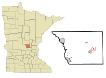
Location of Ronneby, Minnesota and Benton Counties
|
|
| Basic data | |
| Foundation : | 1899 |
| State : | United States |
| State : | Minnesota |
| County : | Benton County |
| Coordinates : | 45 ° 41 ′ N , 93 ° 52 ′ W |
| Time zone : | Central ( UTC − 6 / −5 ) |
| Residents : | 16 (as of 2000) |
| Population density : | 26.7 inhabitants per km 2 |
| Area : | 0.6 km 2 (approx. 0 mi 2 ) of which 0.6 km 2 (approx. 0 mi 2 ) is land |
| Height : | 340 m |
| Area code : | +1 320 |
| FIPS : | 27-55366 |
| GNIS ID : | 0650235 |
Ronneby was a city in Benton County in the US -amerikanischen State Minnesota . With a population of 16, it was one of the smallest cities in the United States in the 2000 census . Therefore, the city was dissolved in May 2009 and as a Unincorporated Community a part of Maywood Township .
geography
Ronneby is located in central Minnesota in the American Midwest . The place belongs to the metropolitan region around the city of St. Cloud . The West Branch Saint Francis River, a tributary of the Saint Francis River, flows along the town . According to the United States Census Bureau , the area of the city was 0.6 square kilometers and has no significant body of water.
The Minnesota State Route 23 through the village.
history
Ronneby was built on a railway line between St. Cloud and Duluth . The place was originally called St. Francis, but was changed with the opening of the post office in 1897, because another place in Minnesota had the same name. The current name comes from the Swedish city of Ronneby . The place received the status of a village on August 31, 1899 . In 1974 Ronneby became a statutory city . In November 2008, the residents of Ronneby decided with 19 to 8 votes to dissolve the city.
Population development
| 1970 | 1980 | 1990 | 2000 |
|---|---|---|---|
| 59 | 56 | 58 | 16 |
Individual evidence
- ^ Warren Upham: Minnesota Place Names: A Geographical Encyclopedia (Minnesota) . 2001, page 53.
