Mille Lacs County
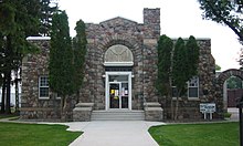
![The Mille Lacs County Courthouse in Milaca, listed in the NRHP since 1977 [1]](https://upload.wikimedia.org/wikipedia/commons/thumb/8/8b/Mille_Lacs_Courthouse.jpg/298px-Mille_Lacs_Courthouse.jpg) The Mille Lacs County Courthouse in Milaca, listed on the NRHP since 1977 |
|
| administration | |
|---|---|
| US state : | Minnesota |
| Administrative headquarters : | Milaca |
| Address of the administrative headquarters: |
County Courthouse 635 2nd Street, SE Milaca, MN 56353-1305 |
| Foundation : | May 23, 1857 |
| Made up from: | Ramsey County |
| Area code : | 001 320 |
| Demographics | |
| Residents : | 26.097 (2010) |
| Population density : | 17.5 inhabitants / km 2 |
| geography | |
| Total area : | 1766 km² |
| Water surface : | 278 km² |
| map | |
| Website : www.co.mille-lacs.mn.us | |
The Mille Lacs County is a county in the US -amerikanischen State Minnesota . In 2010 , the county had 26,097 residents and a population density of 17.5 people per square kilometer. The county seat is Milaca .
Portions of the Anishinabe Mille Lacs Indian Reservation are located in Mille Lacs County.
geography
The county is east of the geographic center of Minnesota on the south shore of Mille Lacs Lake . It has an area of 1766 square kilometers, of which 278 square kilometers are water. The following neighboring counties border Mille Lacs County:
| Crow Wing County | Aitkin County | |
| Morrison County |

|
Kanabec County |
| Benton County | Sherburne County | Isanti County |
history
Mille Lacs County was formed on May 23, 1857 from parts of Ramsey County. It was named after the Mille Lacs Lake , whose name is derived from the French expression Grand lac du Pays des Mille Lacs (Great Lake in the Land of a Thousand Lakes).
One place in Mille Lacs County has the status of a National Historic Landmark , the Kathio Site . A total of 12 buildings and sites in the county are listed on the National Register of Historic Places (as of January 31, 2018).
Demographic data
| Population development | |||
|---|---|---|---|
| Census | Residents | ± in% | |
| 1860 | 73 | - | |
| 1870 | 1109 | 1,419.2% | |
| 1880 | 1501 | 35.3% | |
| 1890 | 2845 | 89.5% | |
| 1900 | 8066 | 183.5% | |
| 1910 | 10,705 | 32.7% | |
| 1920 | 14,180 | 32.5% | |
| 1930 | 14,076 | -0.7% | |
| 1940 | 15,558 | 10.5% | |
| 1950 | 15,165 | -2.5% | |
| 1960 | 14,560 | -4% | |
| 1970 | 15,703 | 7.9% | |
| 1980 | 18,430 | 17.4% | |
| 1990 | 18,670 | 1.3% | |
| 2000 | 22,330 | 19.6% | |
| 2010 | 26.097 | 16.9% | |
| Before 1900 1900–1990 2000 2010 | |||
According to the 2010 census , Mille Lacs County had 26,097 people in 10,594 households. The population density was 17.5 inhabitants per square kilometer. Statistically, 2.41 people lived in each of the 10,594 households.
The racial the population was composed of 91.4 percent white, 0.4 percent African American, 6.0 percent Native American, 0.4 percent Asian and other ethnic groups; 1.8 percent were descended from two or more races. Hispanic or Latino of any race was 1.6 percent of the population.
25.1 percent of the population were under 18 years old, 58.5 percent were between 18 and 64 and 16.4 percent were 65 years or older. 49.7 percent of the population was female.
The median income for a household was 46,100 USD . The per capita income was $ 22,221. 13.4 percent of the population lived below the poverty line.
Localities in Mille Lacs County
1 - partially in Sherburne County
In addition to the eight cities, Mille Lacs County is divided into 17 townships :
|
|
|
See also
- Mille Lacs County Courthouse
- List of entries on the National Register of Historic Places in Mille Lacs County
Individual evidence
- ↑ Extract from the National Register of Historic Places - No. 77000756. Retrieved January 13, 2019
- ↑ GNIS-ID: 659493. Retrieved on February 22, 2011 (English).
- ↑ a b c U.S. Census Bureau, State & County QuickFacts - Mille Lacs County, MN ( July 14, 2011 memento on WebCite ) Retrieved May 23, 2013
- ↑ a b National Association of Counties.Retrieved May 23, 2013
- ↑ Listing of National Historic Landmarks by State: Minnesota . National Park Service , accessed January 31, 2018.
- ↑ Search mask database in the National Register Information System. National Park Service , accessed January 31, 2018.
- ^ US Census Bureau - Census of Population and Housing.Retrieved March 15, 2011
- ^ Extract from Census.gov.Retrieved February 18, 2011
- ^ Census 2010 - Minnesota , Retrieved May 5, 2020
Web links
Coordinates: 45 ° 56 ' N , 93 ° 38' W


