Olmsted County
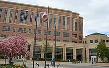
 Olmsted County Courthouse (1915) |
|
| administration | |
|---|---|
| US state : | Minnesota |
| Administrative headquarters : | Rochester |
| Address of the administrative headquarters: |
County Courthouse 151 SE 4th Street Rochester, MN 55904-3761 |
| Foundation : | February 20, 1855 |
| Made up from: |
Fillmore County Rice County Wabasha County |
| Area code : | 001 507 |
| Demographics | |
| Residents : | 144,248 (2010) |
| Population density : | 85.3 inhabitants / km 2 |
| geography | |
| Total area : | 1695 km² |
| Water surface : | 4 km² |
| map | |
| Website : www.co.olmsted.mn.us | |
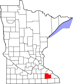
The Olmsted County is a county in the US -amerikanischen State Minnesota . In 2010 , the county had 144,248 residents and a population density of 85.3 people per square kilometer. The county seat is Rochester .
geography
The county is located almost in southeast Minnesota. It has an area of 1695 square kilometers, of which four square kilometers are water. The following neighboring counties border Olmsted County:
| Goodhue County | Wabasha County | |
| Dodge County |

|
Winona County |
| Mower County | Fillmore County |
history
Olmsted County was formed on February 20, 1855 from parts of Fillmore County, Rice County and Wabasha County. It was named after David Olmsted (1822–1861), the first mayor of Saint Paul .
One place in Olmsted County has the status of a National Historic Landmark , the Plummer Building . 25 buildings and sites in the county are registered in the National Register of Historic Places (as of January 31, 2018).
Demographic data
| Population development | |||
|---|---|---|---|
| Census | Residents | ± in% | |
| 1860 | 9524 | - | |
| 1870 | 19,793 | 107.8% | |
| 1880 | 21,543 | 8.8% | |
| 1890 | 19,806 | -8.1% | |
| 1900 | 23,119 | 16.7% | |
| 1910 | 22,497 | -2.7% | |
| 1920 | 28,014 | 24.5% | |
| 1930 | 35,426 | 26.5% | |
| 1940 | 42,658 | 20.4% | |
| 1950 | 48,228 | 13.1% | |
| 1960 | 65,532 | 35.9% | |
| 1970 | 84.104 | 28.3% | |
| 1980 | 92.006 | 9.4% | |
| 1990 | 106,470 | 15.7% | |
| 2000 | 124.277 | 16.7% | |
| 2010 | 144,248 | 16.1% | |
| Before 1900 1900–1990 2000 2010 | |||

According to the 2010 census , Olmsted County had 144,248 people in 56,601 households. The population density was 85.3 inhabitants per square kilometer. Statistically, 2.47 people lived in 56,601 households.
The racial the population was composed of 87.0 percent white, 5.0 percent African American, 0.3 percent Native American, 5.6 percent Asian, 0.1 percent Polynesian and other ethnic groups; 2.0 percent were descended from two or more races. Hispanic or Latino of any race was 4.3 percent of the population.
25.0 percent of the population were under 18 years old, 62.1 percent were between 18 and 64 and 12.9 percent were 65 years or older. 51.1 percent of the population was female.
The median income for a household was 66,202 USD . The per capita income was $ 33,850. 8.1 percent of the population lived below the poverty line.
Localities in Olmsted County
1 - partly in Fillmore County
2 - partly in Goodhue County
3 - partly in Dodge County
structure
In addition to the eight cities, Olmsted County is divided into 18 townships :
|
|
religion
Olmsted County is part of the Catholic diocese of Winona-Rochester . St. John Evangelist (Rochester) is the co- cathedral of this diocese.
See also
Individual evidence
- ↑ GNIS-ID: 659500. Retrieved on February 22, 2011 (English).
- ↑ a b c U.S. Census Bureau, State & County QuickFacts - Olmsted County, MN ( July 15, 2011 memento on WebCite ) Retrieved January 24, 2013
- ↑ a b National Association of Counties.Retrieved January 24, 2013
- ↑ Listing of National Historic Landmarks by State: Minnesota . National Park Service , accessed January 31, 2018.
- ↑ Search mask database in the National Register Information System. National Park Service , accessed January 31, 2018.
- ^ US Census Bureau _ Census of Population and Housing.Retrieved February 17, 2011
- ↑ Extract from Census.gov.Retrieved February 17, 2011
- ^ Census 2010 - Minnesota , Retrieved May 5, 2020
Web links
Coordinates: 44 ° 0 ′ N , 92 ° 24 ′ W


