Owatonna
| Owatonna | |
|---|---|
 Downtown Owatonna |
|
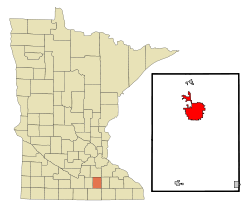
| Location in county and Minnesota | |
| Basic data | |
| Foundation : | August 9, 1858 |
| State : | United States |
| State : | Minnesota |
| County : | Steele County |
| Coordinates : | 44 ° 5 ′ N , 93 ° 13 ′ W |
| Time zone : | Central ( UTC − 6 / −5 ) |
| Residents : | 25,599 (as of 2010) |
| Population density : | 787.7 inhabitants per km 2 |
| Area : | 32.8 km 2 (approx. 13 mi 2 ) of which 32.5 km 2 (approx. 13 mi 2 ) are land |
| Height : | 351 m |
| Postal code : | 55060 |
| Area code : | +1 507 |
| FIPS : | 27-49300 |
| GNIS ID : | 0649095 |
| Website : | www.ci.owatonna.mn.us |
| Mayor : | Thomas Kuntz |
 The Steele County Courthouse in Owatonna, listed on the NRHP since 1978 |
|
Owatonna is a city (with the status " City ") and the administrative seat of Steele County in the US -amerikanischen State Minnesota . In 2010 Owatonna had 25,599 residents. The city hosts the August Steele County Free Fair each year .
geography
Interstate 35 and US Highways 14 and 218 run through the metropolitan area. With the Owatonna Degner Regional Airport there is a small airfield in the northeast of the city area.
According to the data of the United States Census Bureau , the place has an area of 32.8 km² , of which 32.6 km² is land and 0.2 km² (= 0.55%) is water. The oldest part of the city is in a lower-lying area on the eastern bank of the Straight River , south of Maple Creek . The city has expanded in all directions and lies on both banks and on the ridge north of Maple Creek. In recent years, the city has grown particularly in the north-east, north and south-east.
On the southern edge of the city, Kaplans Woods is a nature reserve that consists of a hardwood forest. Cinder Hill is a steep hill about twenty meters high that overlooks Linn Avenue in the center. There is a dam on the Straight River that originally served to drive a mill and has since been retrofitted with a fish ladder.
history
Owatonna was first settled in 1853. The town became the seat of the State Fair in 1883, and a little later the county began its own exhibition here, the Steele County Free Fair ; today it is the largest independent event of its kind in Minnesota.
economy
Owatonna is an economic center for southern Minnesota. Federated Insurance is the largest employer with around 1,500 employees, followed by Viracon . The two companies are based in the city. Other major employers are SPX Corporation , Jostens , Cabela's , Truth Hardware , ISD 761 , Wenger Corporation . There are also the Owatonna Clinic - Mayo Health Systems and Owatonna Hospital - Allina Hospitals And Clinics hospitals .
More recently, a number of retail and restaurant chains have set up shop in Owatonna.
crime
Owatonna had a score of 200.5 points in 2015 (US average: 286 points). Owatonna is 41% safer than the US average, and the chance of getting involved in a crime in Owatonna is 1 in 40.
Politics and administration
Owatonna is administered by a mayor and a city council.
The city is located in Minnesota's 26th congressional electoral district, and at the state level Owatonna is part of the first constituency of Minnesota Congress.
education
Public schools
- Lincoln Elementary, Grades K-5
- McKinley Elementary, Grades K-5
- Washington Elementary, Grades K-5
- Wilson Elementary, Grades K-5
- Owatonna Junior High School, Grades 7–8
- Willow Creek Intermediate School, Grade 6
- Owatonna Senior High School, grades 9-12
Private schools
- El Shaddai School, Grades K-12
- Owatonna Christian School, Grades K-12
- St. Marys Catholic School, Grades K-8
higher education
- Owatonna College and University Center
Attractions
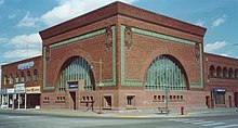
National Farmers Bank
In the middle of downtown Owatonna is the National Farmer's Bank building , designed by Louis Sullivan in the style of the Prairie School of Architecture and completed in 1908. Features of the building include the arches adorned with gold leaf, the stained glass windows and the neo-baroque design. It is on the National Register of Historic Places and is now a branch of the Wells Fargo Banking Institute .
State School Museum
The Minnesota State School for Dependent and Neglected Children was built in 1886. The school was a boarding school for orphans from the state who were accepted and learned the value of drill, discipline, and work . The children who died in the institution were buried in the cemetery behind the school. The orphanage was closed in 1945 and the facility now serves disabled children. In 1974 the city administration bought the building to be used as office space. The facility has been renamed West Hills and serves as the administrative center for the city, which also houses several non-profit organizations, such as a senior center, two day care facilities and the Big Brothers / Big Sisters initiative .
| Population development | |||
|---|---|---|---|
| Census | Residents | ± in% | |
| 1860 | 609 | - | |
| 1870 | 2070 | 239.9% | |
| 1880 | 3161 | 52.7% | |
| 1890 | 3849 | 21.8% | |
| 1900 | 5561 | 44.5% | |
| 1910 | 5658 | 1.7% | |
| 1920 | 7252 | 28.2% | |
| 1930 | 7654 | 5.5% | |
| 1940 | 8694 | 13.6% | |
| 1950 | 10.191 | 17.2% | |
| 1960 | 13,409 | 31.6% | |
| 1970 | 15,341 | 14.4% | |
| 1980 | 18,632 | 21.5% | |
| 1990 | 19,386 | 4% | |
| 2000 | 22,434 | 15.7% | |
| 2010 | 25,599 | 14.1% | |
| 1860-2000 2010 | |||
Demographic data
According to the 2010 census , Owatonna had 25,599 people in 10,068 households. The population density was 787.7 people per square kilometer. Statistically, 2.49 people lived in each of the 10,068 households.
The racial the population was composed of 91.2 percent white, 3.8 percent African American, 0.3 percent Native American, 0.9 percent Asian and 2.2 percent from other ethnic groups; 1.5 percent were descended from two or more races. Hispanic or Latino of any race was 7.3 percent of the population.
26.9 percent of the population were under 18 years old, 59.3 percent were between 18 and 64 and 13.8 percent were 65 years or older. 51.2 percent of the population was female.
The average annual income for a household was 55,764 USD . The per capita income was $ 26,330. 9.0 percent of the population lived below the poverty line.
Known residents
- Mark H. Dunnell (1823-1904) - Republican MP for the US House of Representatives - lived long in Owatonna and died there
- Harvey H. Johnson (1808-1896) - Democratic MP in the US House of Representatives - lived in Owatonna for a long time and died there
- Arthur Fry (* 1931) - inventor ( post-it label ) and scientist - born in Owatonna
- EG Marshall (1914–1998) - actor (Juror # 4 in The Twelve Jurors ) - born and raised in Owatonna
- Adam Young (* 1986) - founder of the Owl City music project
Individual evidence
- ↑ Extract from the National Register of Historic Places - No. 78001565. Retrieved June 23, 2013
- ↑ a b c American Fact Finder. Retrieved June 23, 2013
- ^ Crime in Owatonna, Minnesota (MN) In: city-data.com , accessed August 25, 2017.
- ^ Owatonna, MN Crime Rates & Statistics In: areavibes.com , accessed August 25, 2017.
- ^ US Decennial Census. Retrieved June 23, 2013
Web links
- Official website
- City of Owatonna Police Website ( July 18, 2011 memento on Internet Archive )
- Owatonna Area Chamber of Commerce and Tourism
- State School Museum ( Memento from September 28, 2013 in the Internet Archive )
- www.city-data.com - Owatonna, Minnesota


