US Highway 218
| map | |
|---|---|

|
|
| Basic data | |
| Overall length: | 319 mi / 513 km |
| Opening: | 1926 |
| States: |
Iowa Minnesota |
| Starting point: |
|
| End point: |
|
| Important cities: | Keokuk, IA Iowa City , IA Cedar Rapids , IA Waterloo , IA Austin , MN Owatonna, MN |
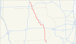
The US Highway 218 is a 513 km long extending in the south-north direction highway through the middle of the United States . Highway 218 is one of the original trunk roads established in 1926. Although numbering 218 would mean that it would have to be a relief road for US Highway 18 , both highways overlap only 13 km at Charles City and then separate again.
The southern terminus of Highway 218 is at the confluence with US Highway 136 in downtown Keokuk in the southeastern corner of Iowa . The northern end forms the joint confluence with US Highway 14 and Interstate 35 on the southern edge of Owatonna in southern Minnesota .
course
The main crossings and junctions
-
 US Highway 136 in Keokuk , Iowa
 -
 US Highway 61 north of Keokuk - 9 km shared route
 -
 US Highway 34 near Mount Pleasant , Iowa
 -
 Interstate 80 near Iowa City , Iowa
 -
 US Highway 6 near Iowa City, Iowa
 -
 Interstate 380 from Iowa City to Cedar Rapids , Iowa - 16 miles shared route
 -
 US Highway 151 at Cedar Rapids, Iowa
 -
 US Highway 30 west of Cedar Rapids - 30 km shared route
 -
 Interstate 380 / US Highway 20 southwest of Waterloo , Iowa
-
 US Highway 63 in Waterloo
 -
 US Highway 18 northwest of Charles City , Iowa - 8 miles common
 -
 Interstate 90 near Austin , Minnesota
 -
 I-35 / US 14 at Owatonna , Minnesota
Iowa
Highway 218 is largely congruent on its course through Iowa with the Avenue of the Saints , in Iowa also numbered as Iowa Highway 27 .
The southern terminus of Highway 218 is at the confluence with US Highway 136 in central Keokuk at the intersection of Iowa, Illinois and Missouri . As Main Street , Highway 218 runs through the entire city until a 9 km long joint course with US Highway 61 to the north begins on the northwestern edge of Keokuk . After the two highways have separated again, Highway 218 now heads northwest.
South of Donnellson , Highway 218 meets Iowa Highway 27 (Avenue of the Saints) for the first time and now runs along with it in a northerly direction. US Highway 34 crosses on the eastern edge of Mount Pleasant and Highway 218 continues north. At Iowa City Highway 218 leads as southwestern tangent over and crosses one after the Interstate 80 and US Highway 6 . Now Highway 218 leads north as Interstate 380 to leave the common route to the west on the southern edge of Cedar Rapids . At the same time, Highway 218 meets US Highway 151 and US Highway 30 , with which the road will now lead together west for the next 30 km.
Then the Highway 218 leaves the common route to the north, in order to turn west again at Vinton and a few kilometers later again north. On the southwestern outskirts of Waterloo , Highway 218 meets Interstate 380 again and US Highway 20, which runs together with it . The road now runs through downtown Waterloo, where US Highway 63 intersects, and then in a north-westerly direction to the northern edge of Cedar Falls . Ahead there, Highway 218 leads north again.
At Charles City , Highway 218 meets US Highway 18 and runs 13 km with it. Then Highway 218 leaves the common route again in a northerly direction. After a few right-angled turns north and west, Highway 218 reaches the border between the states of Iowa and Minnesota .
Minnesota
Coming from the south, Highway 218 reaches the eastern outskirts of Austin and forms the city's eastern bypass. At the Austin regional airport, the highway joins Interstate 90 and runs a few kilometers west with it on the northern outskirts. A little later the common route ends and Highway 218 turns north.
The Highway 218 now leads through a series of smaller towns in the north before the southeastern outskirts of Owatonna in the US Highway 14 opens and passes together with this to the west. After 3 miles, Highway 218 reaches its northern terminus where it joins Interstate 35 .
Officially, Highway 218 is designated Route 40 on its Minnesota section under Minnesota Statutes Section 161.114 (2) .
history
In 1913 the road was built, which is now designated as Highway 218 nationwide. Today's road was first called the Red Ball Route as it was marked with boundary posts with red balls at the top. In 1920 the section through Minnesota was designated as Constitutional Route 40 according to the official street numbering of the state of Minnesota.
In Iowa, Highway 218 was extended in 1934 from its former southern end on US Highway 30 to its current terminus in Keokuk.
See also
Individual evidence
- ↑ US Highways ( Memento of the original of May 13, 2007 in the Internet Archive ) Info: The archive link was automatically inserted and not yet checked. Please check the original and archive link according to the instructions and then remove this notice.
- ↑ usends.com ( Memento of the original from April 17, 2010 in the Internet Archive ) Info: The archive link was inserted automatically and has not yet been checked. Please check the original and archive link according to the instructions and then remove this notice.
- ^ Minnesota's Constitutional Routes
- ↑ Minnesota Codified Laws
