US Highway 136
| map | |
|---|---|

|
|
| Basic data | |
| Overall length: | 804 mi / 1294 km |
| Opening: | 1951 |
| States: |
Nebraska Missouri Iowa Illinois Indiana |
| Starting point: |
|
| End point: |
|
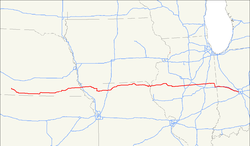
The US Highway 136 (just US 136 ) is a United States highway in the United States and a secondary route for US Highway 36 . It begins on US Highways 6 and 34 in Edison and ends on Interstates 74 and 465 in Indianapolis .
history
In Missouri , large parts of US 136 were designated Route 4 . This began at Saint Joseph and followed US Highway 169 to Stanberry and then to the Iowa border . The other parts of the road in Missouri were designated as Route 1 , Route 1A, and Route 18 .
Web links
- End of US Highways (English)
