
US Highway 93
|
|
|
|---|---|
| map | |

|
|
| Basic data | |
| Overall length: | 1457 mi / 2345 km |
| Opening: | 1926 |
| States: |
Montana Idaho Nevada Arizona |
| Starting point: |
|
| End point: | BC 93 on the Canadian border |

The US Highway 93 is a major north-south route in the west of the United States . It begins on US Highway 60 in Wickenburg , a small town about 90 km from Phoenix , and ends on British Columbia Highway 93 on the Canadian border .
Between West Wendover and Ely , the highway is part of the Lincoln Highway , the first highway to cross America.
At the Hoover Dam near Las Vegas , the street has been crossing the Colorado River on the Hoover Dam Bypass since 2010 .

US 93 at Alamo
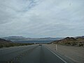
Between Boulder City and the Hoover Dam

US 93 in Lakeside (Montana)


Web links
- End of US Highways (English)
US Highway 1 |
2 |
3 |
4 |
5 |
6 |
7 |
8 |
9 |
10 |
11 |
12 |
13 |
14 |
15 |
16 |
17 |
18 |
19 |
20 |
21 |
22 |
23 |
24 |
25 |
26 |
27 |
28 |
29 |
30 |
31 |
32 |
33 |
34 |
35 |
36 |
37 |
38 |
40 |
41 |
42 |
43 |
44 |
45 |
46 |
48 |
49 |
50 |
51 |
52 |
53 |
54 |
55 |
56 |
57 |
58 |
59 |
60 |
61 |
62 |
63 |
64 |
65 |
66 |
67 |
68 |
69 |
70 |
71 |
72 |
73 |
74 |
75 |
76 |
77 |
78 |
79 |
80 |
81 |
82 |
83 |
84 |
85 |
87 |
89 |
89A |
90 |
91 |
92 |
93 |
94 |
95 |
96 |
97 |
98 |
99 |
101 |
150 |
151 |
163 |
218 |
400 |
412 |
425
This is a list of the major routes used by the US highway system. Secondary routes can be reached from the article of the respective main route (with identical end digits).
See also: List of United States Highways .