
US Highway 95
|
|
|
|---|---|
| map | |

|
|
| Basic data | |
| Overall length: | 1574 mi / 2533 km |
| Opening: | 1926 |
| States: |
Arizona California Nevada Oregon Idaho Washington |
| Starting point: | MX 2 (Mexican Federal Highway 2) near San Luis |
| End point: | BC 95 on the Canadian border |

The US Highway 95 (short US 95 ) is a major north-south route in the western United States . It begins on the Mexican border in San Luis , a small town in the extreme southwest of Arizona , and ends after 2,533 kilometers on British Columbia Highway 95 (BC 95) on the Canadian border .
Due to the rural remoteness of the US 95, unlike most other US highways , almost its entire length remains in its original route and has not been replaced by modern interstates . Even today it runs from the state border to Mexico in the south to the state border to Canada in the north and is the most important north-south connection in both Idaho and Nevada .
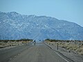
US 95 between Beatty and Scotty's Junction

US 95 in Tonopah
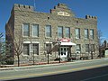
Courthouse on Highway 95 in Goldfield

US 95 in Cambridge (Idaho)

Junction US 95 with State Route 267 at Scotty's Junction
.JPG)


Web links
- End of US Highway 95 (English)
US Highway 1 |
2 |
3 |
4 |
5 |
6 |
7 |
8 |
9 |
10 |
11 |
12 |
13 |
14 |
15 |
16 |
17 |
18 |
19 |
20 |
21 |
22 |
23 |
24 |
25 |
26 |
27 |
28 |
29 |
30 |
31 |
32 |
33 |
34 |
35 |
36 |
37 |
38 |
40 |
41 |
42 |
43 |
44 |
45 |
46 |
48 |
49 |
50 |
51 |
52 |
53 |
54 |
55 |
56 |
57 |
58 |
59 |
60 |
61 |
62 |
63 |
64 |
65 |
66 |
67 |
68 |
69 |
70 |
71 |
72 |
73 |
74 |
75 |
76 |
77 |
78 |
79 |
80 |
81 |
82 |
83 |
84 |
85 |
87 |
89 |
89A |
90 |
91 |
92 |
93 |
94 |
95 |
96 |
97 |
98 |
99 |
101 |
150 |
151 |
163 |
218 |
400 |
412 |
425
This is a list of the major routes used by the US highway system. Secondary routes can be reached from the article of the respective main route (with identical end digits).
See also: List of United States Highways .