US Highway 51
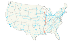
| map | |
|---|---|

|
|
| Basic data | |
| Overall length: | 1286 mi / 2070 km |
| Opening: | November 11, 1926 (Presentation) |
| States: |
Louisiana Mississippi Tennessee Kentucky Illinois Wisconsin |
| Starting point: | Hurley |
| End point: | La Place |
The US Highway 51 (short US 51 ) is a United States highway in the United States . It begins in Hurley , Wisconsin and ends after 2070 kilometers in Laplace .
location
The US Route 51 is a highway that about 2,070 km is (1,286 miles) from the western suburbs of New Orleans , Louisiana to a length of 30 meters from the border of Michigan extends to Wisconsin. Much of the highway is in Illinois and southern Wisconsin, it runs parallel to Interstate 39 (I-39), but most of it runs parallel to the Illinois Central Railroad . The northern end of the freeway is between Hurley, Wisconsin and Ironwood , Michigan, where the freeway ends with a T interchange. The southernmost terminus is in Laplace, Louisiana, and ends at US 61.
history
US Highway 51 is one of the "major roads" of the American Midwest and one of the original routes created by the American Association of State Highway Officials (AASHO, now AASHTO) in November 1926. At that time, US 51 began in downtown New Orleans, where it was doubled with another north-south highway, US Highway 61. The two routes split north of New Orleans, near today's actual starting point of US 51 in La Place, Louisiana.
Individual evidence
- ↑ US Highway 51, accessed December 21, 2018.
