New Orleans
| New Orleans | |
|---|---|
| Nickname : The Crescent City, The Big Easy, The City That Care Forgot, 504, NOLA | |
 New Orleans skyline |
|
 seal |
 flag |
| New Orleans | |
| Basic data | |
| Foundation : | 1718 |
| State : | United States |
| State : | Louisiana |
| Parish : | Orleans Parish |
| Coordinates : | 29 ° 57 ′ N , 90 ° 5 ′ W |
| Time zone : | Central ( UTC − 6 / −5 ) |
|
Inhabitants : - Metropolitan Area : |
391,006 (as of 2018) 1,263,635 (as of 2018) |
| Population density : | 836 inhabitants per km 2 |
| Area : | 907 km 2 (approx. 350 mi²) of which 467.6 km 2 (approx. 181 mi²) is land |
| Height : | 0 m |
| Postal code : | 70117 |
| Area code : | +1 504 |
| FIPS : | 22-55000 |
| GNIS ID : | 1629985 |
| Website : | www.nola.gov |
| Mayor : | LaToya Cantrell |
 |
|
New Orleans ( American English : [ ˈnuːˈɔrlɪns ] , local: [ ˈnɔrlənz ]) is the largest city in the state of Louisiana in the United States with 391,006 inhabitants (2018) . It is an industrial center with a major port on the Mississippi River . The city is known for its local Creole cuisine and its historic old town, the French Quarter , which is home to numerous buildings in the Spanish and French colonial styles. In addition, New Orleans is considered the "cradle of jazz ".
geography
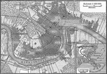
The city is located in the delta of the Mississippi River and has an area of 907.0 km², of which 467.6 km² is land and 439.4 km², or 48.45%, is water. Because of its location between the Mississippi in the south and Lake Pontchartrain in the north, which gave it a city outline in the form of a crescent moon, New Orleans was named Crescent City . The Algiers district is located on the west bank opposite the old town .
When the city was founded, French settlers built a small, slightly elevated piece of land that is now known as the French Quarter . The area of what is now New Orleans was formed only 2500 years ago from sediments washed up by the river . For the most part, it is a swamp several hundred meters deep that compacts under the pressure of its own weight and, if the sediment does not deposit, will sink further below sea level . Since the Mississippi was diked by the French and then by the United States Army Corps of Engineers , the area of New Orleans has been sinking about 8 mm per year. 70% of the city's area is up to 1.6 m below sea level, with the adjacent 1839 km² Lake Pontchartrain being connected to the Gulf of Mexico via the Rigolets Strait waterway and the Lake Borgne lagoon .
From 1910 onwards, Albert Baldwin Wood drained the town, which is surrounded by swamps, with numerous large pumps. The nature park Barataria Preserve in Marrero, located on the southern side of the Mississippi, shows remnants of the original landscape in the Mississippi Delta. A drainage system several hundred kilometers long runs through New Orleans today and drains the entire city via 22 pumping stations in heavy rain. The drainage allowed New Orleans to be expanded by considerable areas, but it also led to an extensive subsidence of the terrain. Today the city is protected against water ingress by a 5 to 6 meter high dike in the north and a 9 meter high dike in the south.
climate
| New Orleans | ||||||||||||||||||||||||||||||||||||||||||||||||
|---|---|---|---|---|---|---|---|---|---|---|---|---|---|---|---|---|---|---|---|---|---|---|---|---|---|---|---|---|---|---|---|---|---|---|---|---|---|---|---|---|---|---|---|---|---|---|---|---|
| Climate diagram | ||||||||||||||||||||||||||||||||||||||||||||||||
| ||||||||||||||||||||||||||||||||||||||||||||||||
|
Climate diagram New Orleans
Source: Klimatabelle.info
|
|||||||||||||||||||||||||||||||||||||||||||||||||||||||||||||||||||||||||||||||||||||||||||||||||||||||||||||||||||||||||||||||||||||||||||||||||||||||||||||||||||||||||||||||||||||||||||||||
story
Colonial times
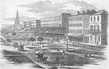
New Orleans was founded in 1718 by the French Jean-Baptiste Le Moyne de Bienville and was named La Nouvelle-Orléans in honor of the regent of France, Philip II, Duke of Orléans . In 1722 the city became the capital of the Louisiana colony . Since 1721 at the latest, German-speaking colonists were settled by the French colonial administration in the immediate vicinity of New Orleans. In 1762 the colony went to Spain under the secret Fontainebleau Agreement , which was confirmed in the Peace of Paris in 1763 ; until 1766, however, no Spanish governor was installed.
On Good Friday, March 21, 1788, the city was almost completely destroyed by a major fire. 856 of the approximately 1100 buildings in the city fell victim to the flames. After only six years of reconstruction, another fire destroyed more than 200 houses in the French Quarter on December 8, 1794 .
Acquisition by the United States
In 1795, Spain granted the United States the right of settlement in the Pinckney Treaty and allowed the Americans to use the city's port. As part of the San Ildefonso Agreement, dictated by Napoleon Bonaparte in 1800 , the area west of the Mississippi , which was assigned to Spain in 1763, went back to France. In 1803, Napoleon sold the entire colony to the United States under President Thomas Jefferson for $ 15 million in the so-called Louisiana Purchase . New Orleans, which had a population of about 10,000 at the time, was officially handed over to the United States on December 20, 1803. The contract, signed in Paris, was publicly announced in the Cabildo building on Jackson Square, the city's former Spanish town hall - now the Louisiana State Museum . In a parade, the French soldiers marched out and the American soldiers moved in, the flag was changed on the flagpole in the square.
Rise to the center of the southern United States
From its early days, New Orleans was known for its cosmopolitan and polyglot population and the numerous cultures that existed there. The city grew rapidly with influences from France, America, and the Creole Caribbean. During the British-American War , the British wanted to conquer the city, but they were repulsed by troops led by General Andrew Jackson a few miles downstream on January 8, 1815 ( Battle of New Orleans ).
The city population doubled in the 1830s and 1840s, and New Orleans became the largest city in the American South and outside the Atlantic Seaboard. New Orleans was the capital of the state of Louisiana until 1849 , later again from 1865 to 1882. The port was especially important for the slave trade, although New Orleans was also the city with the most colored people in North America.
The city gained in importance when the government established a local mint next to the southern mints of Charlotte, North Carolina, and Dahlonega in 1838 . Unlike the other two coins were in New Orleans next to gold too - silver - coins embossed, which may have contributed to the position as the most important mint in the south.
In 1853, New Orleans was hit by a severe yellow fever epidemic that killed nearly 8,000 people.
During the American Civil War , New Orleans was conquered by the Union without a fight on April 28, 1862 by a ship operation led by Admiral David Glasgow Farragut , whereby a large part of the historic buildings were preserved. A major draw for tourists from all over the world in the late 19th and early 20th centuries was the famous red light district of Storyville .
New Orleans in the 20th century

To this day, New Orleans is also known for its Creole and Voodoo culture, which came to America with the slave trade from Africa . The city is also known for its diverse musical styles . This is how, as a synthesis of various musical traditions - including the street bands that dominated the streets at the time - jazz has emerged since the turn of the century , which flourished here especially in the early 1920s.
At the same time the modernization of the cityscape, the old cast-iron balconies on Canal Street were removed in the 1960s to replace the city's Canal Streetcar Line ( tram ) by buses . Both measures were reversed in the 1990s.
In 1927 the Mississippi flooded an area of about 70,000 km² and made several 100,000 people homeless. The trigger for the Mississippi flood in 1927 was prolonged rain. It began in August 1926 and lasted until the spring of 1927. At that time, the levees at the town of Poydras, 18 km away, were blown up over a length of 450 m to protect New Orleans from the masses of water. In 1965, New Orleans experienced its worst hurricane disaster to date. Hurricane Betsy flooded much of the city, leaving thousands of New Orleans and Louisiana residents homeless.
Population development
New Orleans' first residents were a mix of Canadian frontier residents, artisans, and troops from John Law's Society of the West , who ruled the area until it was returned to the French Crown Colony in 1731, as well as inmates, black and Native American slaves. In 1727, 88 women freed from Parisian prisons reached the city, accompanied by eight Ursuline nuns, to settle in the city. The intrepid nuns settled in what is now Chartres Street; a convent was also built a little further down the road. This building, the construction of which began in 1745 and which is located near what is now the French Market , is the only remaining building from the period of French rule.
French adventurers and other Europeans soon followed the first settlers. The term Creole , coined and used in the French West Indies, was introduced in Louisiana to denote a person who was born there as a pure French. The ancestry and the term go back to the Spanish word criollo , which denoted the first generation of Spanish parents in the New World.
In 1755 a group of Cajuns came to the area. They were descendants of French colonists who had settled in Acadia , the later Canadian province of Nova Scotia , and were driven out there by the British . The Spanish took control of the city in 1762, four years after the Fontainebleau Agreement . After suppressing a revolt, they settled down and shaped the city with their architecture and way of life. From the 19th to the early 20th centuries, there was a great wave of immigration to the United States, bringing Germans, Irish, and Italians to New Orleans.
Despite the French name of the city, French is hardly spoken any more, but since 1968 the state of Louisiana has been promoting the revival of the French language ( see French in Louisiana ).
According to the United States Census Bureau, the city of New Orleans had 454,863 inhabitants until the evacuation on August 28, 2005 as a result of Hurricane Katrina (as of July 1, 2005). On July 1, 2006 it was only about half of 223,388 and in July 2007, almost two years after the disaster, the number had only risen to 239,124 inhabitants. It was to be feared that there would hardly be much more in the coming years, since safe flood protection in the deep-lying core zones with a financially justifiable expense is hardly conceivable and many former residents cannot financially afford to return. For urban planners, it opened up new design options on the destroyed (and abandoned) residential areas.
According to the results of the 2010 census, the population increased to 343,829.
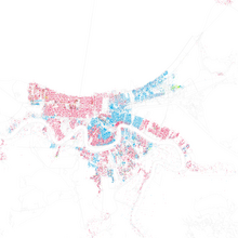
The population density was 478 inhabitants per square kilometer. 28.05 percent white people lived in the city; 67.25 percent African American ; 0.20 percent Native American; 2.26 percent Asians and 3.06 percent Hispanics. In the New Orleans metropolitan area, the population on July 1, 2005 was 1,313,787. On July 1, 2006, it was 1,024,678, around 300,000 fewer.
The following overview shows the number of inhabitants according to the respective territorial status. From 1769 to 1800 and from 2005 to 2007 these are estimates by the United States Census Bureau, and for the full decades from 1810 to 2010 they are census results .
|
|
|
According to Jakob / Schorb (2008), the estimates of the residents for March 2008 fluctuate between the City Council, which assume 300,000 returnees, and the federal authorities, which assume 240,000 returnees. The two sociologists attribute the different assessments to their different interests: "The amount of federal subsidies to the financially weak municipality is based on the size of the population."
On July 1, 2013, the population of the city was again at 378,715, compared to 223,388 exactly 7 years earlier. The city's growth appears to be continuing, with a 10.1 percent increase between the 2010 census and July 1, 2013, compared to 2.1 percent for all of Louisiana.
Hurricanes
New Orleans is in the catchment area of hurricanes . Hurricanes are tropical storms that form over the Atlantic Ocean between May and October . The most devastating to date, Hurricane Katrina , struck the city on August 29, 2005 and caused almost complete devastation of the city in connection with a flood disaster that was caused by the hurricane.
Hurricane Katrina 2005
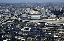
On August 29, 2005, New Orleans was hit by Hurricane Katrina , one of the four worst hurricanes ever recorded in the United States. Although New Orleans was only affected by the tail of the hurricane, the walls of two canals broke, causing the waters of Lake Pontchartrain to flood the city almost completely. The city's large water pumps also failed. Washed down buildings collapsed, which made the situation much worse. Water, rubbish and rubble washed into the Superdome, which was used as an emergency shelter . This was the target of those who did not leave the city in time and were waiting there for the army to distribute water and food. In addition, water and power failures made conditions inside the stadium worse.
On August 30, 2005, the walls of the Industrial Canal, which connects Lake Pontchartrain in the north of the city with the Mississippi south of the center, also collapsed, and water ran into the lowest-lying neighborhoods. A day later, several districts of the jazz metropolis were flooded again. This particularly affected the social housing estates of the “Big Four”, so-called Public Housing Projects, which were built between 1941 and 1955 in the lower-lying areas in parts of the center that were unpopular as residential areas at the time. The water in Ninth Ward stood two meters high in the streets and three quarters of all residents had to flee or were evacuated.
When the extent of the flooding became clear, the government decided on August 31 to completely evacuate the city - and with it the Superdome - first with buses and later with an airlift . The first destination was the Houston Astrodome , but its capacity was exhausted after just one day. After a few days of emergency, a state of emergency , martial law and a health emergency were declared .
The Louis Armstrong New Orleans International Airport , which is about 300 daily flights dispatches, could be put into operation again after a few days. Since it is located a little west of the city in the largely spared suburb of Kenner , the runway and tower were not destroyed by the hurricane, but ground radar and runway lighting were initially no longer available.
On September 5, 2005 it was announced that the dike to Lake Pontchartrain had been repaired, but that pumping out the water would take at least three months. High-performance pumps provided by the German technical aid organization helped on some dykes . On September 6, 2005, Mayor Ray Nagin ordered the evacuation of the last remaining residents in the city. Anyone who was not involved in the reconstruction had to leave the city because of the risk of epidemics. Because the dam had held along the Mississippi, the higher historic riverside districts, including the French Quarter , were spared the flooding.
On September 20, 2005, New Orleans was evacuated again because it was feared that Hurricane Rita would cross the city in the next few days, whereupon the few returnees left the city.
In mid-October 2005 the city was drained again. However, the population had to be prepared for another possible evacuation on October 18 : Hurricane Wilma , whose development was initially uncertain, moved across Florida towards the Atlantic .
City change due to the consequences of the disaster
While the call for a quick reconstruction of New Orleans with appropriate state support grew louder and the political pressure on those responsible grew, doubts also increased as to whether New Orleans should not be given up, as the situation was expected to deteriorate in the future. The city opted for a lower population density, especially in the social housing areas (Public Housing Projects). As part of this gentrification , these public housing projects were largely cordoned off and no longer renovated or demolished. In the inner city in particular, these areas were tendered to real estate companies and sparsely populated residential areas with mixed incomes were built or planned.
The natural disaster hit mostly black and socially disadvantaged residents. John Logan, urban researcher from Brown University in Rhode Island, analyzed the data from the American civil protection agency FEMA. Afterwards, African Americans, the poor, tenants and the unemployed were “disproportionately” affected by the consequences of the hurricane. About 75 percent of the population in the destroyed areas was African American, while the intact areas were predominantly white. Logan concludes that the distribution of risk between economically strong and weak residents was uneven. The poor and black would also have had fewer resources and opportunities to return to New Orleans and rebuild their homes. Even before the disaster, it was clear that the lower areas of the city - residential areas of the blacks and the poor - would be the most vulnerable parts. The journalist Jordan Flaherty stated in 2016: "New Orleans is now smaller, wealthier and whiter than before the storm".
Gustav 2008
At the end of August 2008, Hurricane Gustav threatened the city. Her evacuation was ordered on August 31. The motorway was briefly redesigned into a one-way street out of town, so that thousands of citizens could take the safe route north and north-east. However, the hurricane moved further west towards the coast and New Orleans was largely spared. It showed that the authorities (in particular FEMA ) were now practicing better prevention management, even if the challenges and dimensions cannot be compared with those of Hurricane Katrina.
Attractions
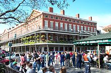
The famous French Quarter , also called "Vieux Carré", which dates back to the French and Spanish times and borders the Mississippi, Rampart Street, Basin Street, Canal Street and Esplanade Avenue, was designed in 1721 by engineer Adrian de Pauger . In particular, the French Market, a place where the Choctaw Indians used to trade, with the Café du Monde , famous for its chicory coffee and fritters , is as big a draw for tourists as the legendary Bourbon Street , where parties are celebrated every evening until the morning. Louis Armstrong Park is located at the northern end of the French Quarter in the Treme district .
Jackson Square is located in the center of the grid-shaped system of the Vieux Carre opposite the river, the water level of which is now well above the level of the historic settlement and is channeled by a dam. The square used to be known as the parade ground as the “Place d 'Armes” (arms square). Soldiers exercised in front of the city church, which was flanked by the headquarters of the Spanish city council. After the Spaniards took over the community, they named the square “Plaza de Armas”. The name Jackson Square originated in the 19th century when an equestrian statue of Andrew Jackson was placed in the center of the square. The Roman Catholic St. Louis Cathedral, founded in 1727, rebuilt from 1789 to 1794 after the city fire of 1788 and renovated from 1850 onwards, is also located on Jackson Square . It is flanked by the late Baroque buildings Cabildo (left) and Presbytere (right), both now part of the Louisiana State Museum , which were built from 1791 onwards .
The Garden District, laid out in 1832 (between St. Charles Avenue, 1st Street, Magazine Street and Toledano Street, around Prytania Street) has one of the best-preserved ensembles of elegant apartment buildings of the antebellum architecture of the early and mid-19th centuries .
Trams
Trams are also part of the flair of New Orleans. The best known is the St. Charles line with its green carriages, which were built by Perley-Thomas in 1924 and which have linked New Orleans with the suburb of Carrollton since 1893. Along the route through St. Charles Avenue you can admire numerous stately mansions from the 19th century in the Garden District. Two private universities are also located here, Tulane University and Loyola University.
Another route is the Riverfront Line, also known as "Ladies in Red", which was reopened in 1988. It runs parallel to the river from Canal Street to the French Quarter. In 2004 the Canal Street line reopened. Among other things, it serves City Park with the New Orleans Museum of Art through a branch in North Carrollton Avenue. The distance to the Tennessee Williams his famous drama A Streetcar Named Desire ( A Streetcar Named Desire ) named, was in 1948, set a year after publication.
graveyards
Because of the low location of New Orleans and the very moist soil associated with it, there are no conventional cemeteries in the city because epidemics are feared. The dead have been buried in mausoleums since 1830 ; these "Cities of the Dead" are tourist attractions. The city developed its own type of burial: a traditional jazz funeral is accompanied by a marching band , the sad, afterlife-oriented music ( hymns ) on the way to the funeral and happy, secular music ( hot jazz ) on the way back plays. This motif is taken up in the film " James Bond 007 - Live and Let Die ".
Historic Buildings
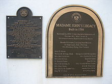
Historic Madame John's Legacy is located in the French Quarter at 632 Dumaine Street . The three-part property was added to the National Register of Historic Places in 1970 and entered the National Historic Landmark because of its formative Creole architectural character .
At 423 Canal Street is the historic Old Post Office and Custom House , which was also listed on the National Register of Historic Places in 1974.
In neighboring districts, which first complemented the old French Quarter, such as Faubourg Marigny , Bywater , Treme , the local Shotgun House is predominant. Before Hurricane Katrina, these idyllic-looking neighborhoods were sometimes poor and not without danger, but have experienced rapid gentrification since the migration of many unemployed from the mostly black population to booming centers such as Houston (Texas) .
Music and parties
New Orleans has always been a center of music. It mixed European styles with those from Latin America and Afro-American cultures. Brass jazz in particular has its roots in New Orleans. One of the most famous music clubs for New Orleans jazz is the Preservation Hall in the French Quarter. The city is also known for rhythm and blues , which shaped rock 'n' roll significantly, and cajun and zydeco music can also be heard in many places. In the late 1980s, some local metal bands coined their own style of doom metal , later known as sludge and often referred to as the NOLA sound .
The most famous music event is the Jazz and Heritage Festival , or Jazz Fest for short, which takes place on two consecutive weekends at the end of April and beginning of May at the Fairgrounds racecourse. Well-known and unknown musicians of various genres perform on many stages, alongside jazz, rock , blues and zydeco can also be heard. A regular guest was, for example, the city-born Dr. John , but also Nelly and Brian Wilson could be heard here.
Another highlight of the city's music calendar is the French Quarter Festival. In mid-April, for a weekend in the French Quarter, mainly on Bourbon Street and Royal Street and Jackson Square, stages will be set up on which local and international bands will give free concerts. The Satchmo SummerFest also attracts many jazz fans; the festival, named after the city's most famous son, Louis Armstrong , takes place every year on the first weekend in August. In addition to the concerts, similar to the French Quarter Festival, there are various exhibitions on jazz and a jazz fair.
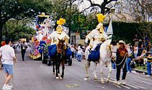
The most famous celebration in New Orleans is the Carnival , which culminates in a procession on the so-called. Mardi Gras is ( French name for the last carnival day ). During the carnival season there are several large parades in and around New Orleans, various krewes (carnival clubs ) design floats (drawn carts) and trucks, drive them through the streets and throw beads, colorful plastic chains. Purple, green and gold are the official colors of Mardi Gras, set by Carnival King Rex in 1872. This "king" represents a swipe at the historical Old World , its monarchs and their patronizing the population.
kitchen
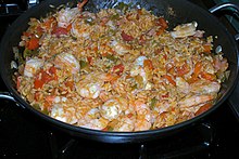
New Orleans is famous for its food culture. Numerous Creole and Cajun dishes such as Crawfish Étouffée , Jambalaya and Gumbo are very popular. The specialties range from Po 'boy (local pronunciation of poor boy = "poor boy"; a kind of filled baguettes ) and muffuletta sandwiches to Bananas Foster to Pompano en Papillote , Gulf oysters and other sea creatures. Another specialty is red beans and rice ; the hearty stew is traditionally served on Mondays.
The often confused terms “creole” and “cajun” in relation to local foods and cultures mean something different. Both cultures were initially based on French immigrants, but the later Creoles came from Europe and soon mixed with Spaniards, Indians and Blacks, while the Cajuns are immigrants from northeast Canada, especially Nova Scotia , and for a long time hardly mixed with the rest of the population. Their settlement area was also largely restricted to southwest Louisiana. Correspondingly, today's Creole cuisine developed through the mixing of all the food traditions of all immigrants, the Cajun cuisine was reluctant to take on new elements.
New Orleans is home to a variety of award-winning restaurants such as Antoine's, Arnaud's, Brennan's or Commander's Palace. The chef Kevin Belton , who is known in the USA through numerous cooking programs and also in Germany through tv.gusto , runs the New Orleans School of Cooking, a cooking school for the city's specialties.
Economy and Infrastructure
The largest company based in New Orleans is Entergy . The New Orleans port is the sixth largest in the United States.
The New Orleans metropolitan area generated an economic output of 67.6 billion US dollars in 2016. In terms of GDP per capita, New Orleans is one of the poorer cities in the country.
shipping
New Orleans is at the junction of the Gulf Intracoastal Waterway , the Mississippi and the Mississippi River-Gulf Outlet Canal , a 106 km long and 10.8 m deep canal from New Orleans Inner Harbor to the Gulf.
Public transport and railroad
The public transport is from the New Orleans Regional Transit Authority operates, in short RTA, it offered bus and tram lines. There is also a connection to the Amtrak railway company (railway junction) and numerous connections to the Greyhound intercity bus company .
Car traffic
The city has a direct motorway connection with Interstate 10 , which extends to the states of California on the west coast and Florida on the east coast. There is a direct connection north to Illinois via Interstate 55 , which begins in the west of the city . North of the city is Interstate 12, a bypass for long-distance traffic around the city. In the center of New Orleans there is a well-developed highway system, which includes Interstate 10, Interstates 310 , 510 and 610 as well as US Highways 61 and 90 . The Crescent City Connection is the only bridge over the Mississippi in the metropolitan area and also the last bridge over the river before its confluence.
airport
New Orleans has several airports, the largest being Louis Armstrong New Orleans International Airport (MSY), which is located in the Kenner suburb .
media
In May 2012, Advance Publications, Inc., publisher of The Times-Picayune newspaper ( 2006 Pulitzer Prize for reporting on Hurricane Katrina ) announced that the paper would no longer appear daily. From 2012 to 2014, the printed version of the newspaper was only available on Wednesdays, Fridays and Sundays. In 2014 they returned to the daily press.
Internet
On December 13, 2019, after a massive cyber attack was discovered, all of the city administration's servers were shut down and a state of emergency declared. Ransomware has been found on some of the city's computers .
Sports
New Orleans is home to three well-known teams from North American professional leagues :
- New Orleans Pelicans , basketball
- New Orleans Saints , American football
- New Orleans Voodoo , Arena Football
Amateur clubs:
- NOLC - New Orleans Lacrosse Club , postcollegiate lacrosse
- New Orleans Jesters , Soccer, National Premier Soccer League (NPSL)
The Mardi Gras Marathon has been taking place since 1965 .
On February 3, 2013, New Orleans hosted the final of the North American professional league NFL , the Super Bowl XLVII, for the 10th time .
Personalities
sons and daughters of the town
Personalities related to the city
- Jelly Roll Morton (1885–1941), pianist, composer and band leader; grew up in New Orleans
- Michael Ellis DeBakey (1908-2008), cardiac surgeon; completed his medical training at Tulane University in New Orleans
- Mary L. Good (1931-2019), chemist; Assistant Professor of Chemistry in New Orleans
- Ruby Bridges (* 1954), first African American in a school reserved for white children until 1960
- C-Murder (* 1971), rapper from New Orleans
- Curren $ y (* 1981), rapper from New Orleans
- Jarboe (* 20th century), singer, musician and performance artist
- Suicideboys rap group from New Orleans
Films and series that are set in New Orleans (selection)
- 12 years a slave
- Angel Heart
- American horror story
- Bad Lieutenant - Cop with no conscience
- Catch Me If You Can
- Cincinnati Kid
- Contraband
- The verdict - everyone is for sale
- Dead Man Walking - His last walk
- Déjà Vu - a race against time
- The man in the snakeskin
- The strange case of Benjamin Button
- The forbidden key
- The wolf chases the pack (tightrope)
- The file
- Double homicide
- Down by law
- Easy rider
- End of the line longing
- Interview with a vampire
- JFK - Dallas Crime Scene
- Johnny Handsome - The handsome Johnny
- Hours - a race against time
- Cat people
- kiss the frog
- James Bond 007 - Live and Let Die
- Lolita
- Lovesong for Bobby Long
- My name is Nobody
- Mississippi Delta - In the Swamp of Vengeance
- NCIS: New Orleans
- Pact of vengeance
- Preacher (TV series) (Season 2)
- Pretty baby
- Black Angel
- Stoles
- The Big Easy - The great carelessness
- The Mechanic
- The Originals
- The Quest - The Curse of the Judas Chalice
- Treme
- Undercover Blues - An absolutely cool trio
- Wild at Heart - The story of Sailor and Lula
- Welcome to the Rileys
- Twelve rounds
Town twinning
New Orleans lists the following fifteen city partnerships :
literature
- Martin Heintel : Urban and Regional Development in the Case of New Orleans ... And a Tentative Public Policy Comparison between the USA and the EU. In: Bischof, G. (Ed.): Regional Economic Development Compared: EU-Europe and the American South , pp. 81–97. Innsbruck 2014: Innsbruck University Press (Edited Volume Series).
- Jerroldyn Hoffmann, Roland Hoffmann: In the eye of the hurricane - How the New Orleans hurricane made us homeless. Lübbe Verlag, 2006, ISBN 3-404-61595-6 .
- Christian Jakob , Friedrich Schorb: Social cleansing. How New Orleans gets rid of its underclass. Unrast Verlag, Münster 2008, ISBN 978-3-89771-484-7 .
- John Kendall: History of New Orleans . Lewis Publishing Company, Chicago and New York 1922.
- John Logan: The Impact of "Katrina": Race and Class in Storm-Damaged Neighborhoods. Center for Spatial Structures in the Social Sciences, Providence 2006, OCLC 63663325 .
- Hilary McLaughlin-Stonham: From Slavery to Civil Rights: On the streetcars of New Orleans 1830s-Present. Liverpool University Press, Liverpool 2020, ISBN 978-1-78962-224-9 .
- Josh Neufeld: AD: New Orleans After the Deluge. Pantheon Verlag, New York 2009, ISBN 978-0-307-37814-9 .
- Tom Piazza : City of Refuge. Novel. HarperCollins Publishers, New York 2008, ISBN 978-0-06-167361-0 .
- Tom Piazza: Why New Orleans Matters. Regan Books, New York 2005, ISBN 0-06-112483-4 .
- Robert Polidori : After the flood - A photo book. Steidl Verlag, Göttingen 2006, ISBN 3-86521-277-8 .
- Sibylle Zerr: Blues for a butterfly. Encounters in New Orleans. Books on Demand, Norderstedt 2006, ISBN 3-8334-5289-7 .
Web links
- Official website of the City of New Orleans
- Satellite imagery of the New Orleans area before and after the flood
- Official New Orleans tourism site
- New Orleans Convention and Visitors Bureau
Individual evidence
- ↑ US Census Bureau QuickFacts: New Orleans city, Louisiana. Retrieved April 17, 2020 .
- ↑ Phys.org: Sea level rise will swallow Miami, New Orleans, study finds
- ^ Climate in New Orleans. Retrieved January 29, 2017
- ↑ Andreas Huebner: The Côte des Allemands A history of migration in Louisiana in the 18th century . Transcript, Bielefeld 2017, ISBN 978-3-8376-4006-9 .
- ^ The Yellow Fever Epidemic in New Orleans - 1853. (No longer available online.) Lafayette Cemetery Research Project, New Orleans, archived from the original on May 9, 2015 ; accessed on June 29, 2015 . Info: The archive link was inserted automatically and has not yet been checked. Please check the original and archive link according to the instructions and then remove this notice.
- ↑ The Pestilence of New Orleans . In: The Gazebo . 1853, p. 432-435 ( full text [ Wikisource ]).
- ^ Study Christian Jakob, Friedrich Schorb: Social cleansing. How New Orleans drove its underclass after the flood. 2008, pp. 10 and 214.
- ↑ United States Census 2010 ( Memento of the original from January 2, 2016 in the Internet Archive ) Info: The archive link was inserted automatically and has not yet been checked. Please check the original and archive link according to the instructions and then remove this notice. , Retrieved March 18, 2015.
- ↑ CNN according to Spiegel-online of September 23, 2005.
- ↑ Christian Jakob, Friedrich Schorb: Social cleansing. How New Orleans drove out its underclass after the flood. 2008.
- ↑ John Logan in: Christian Jakob, Friedrich Schorb: Social cleansing. How New Orleans drove out its underclass after the flood. 2008.
- ↑ Jordan Flaherty: Gift of God. Digital Development Debates, July 2016, accessed on August 11, 2016 (English): "" New Orleans today is smaller, wealthier, and whiter than it was before the storm. ""
- ↑ NRIS
- ^ Louisiana State Museum Madame John's Legacy
- ↑ FAQ. doom-metal.com, archived from the original on March 25, 2010 ; Retrieved December 12, 2015 .
- ↑ crowbarmusic. Crowbarmusic.com, archived from the original on February 24, 2012 ; Retrieved December 12, 2015 .
- ↑ Colorful, more colorful, Mardi Gras . Travel EXCLUSIV magazine website, accessed January 21, 2015.
- ↑ Website suite101.com, May 9, 2000 (Accessed September 29, 2010): "Creole Is Not Cajun & Vice Versa".
- ^ Lafayette Convention & Visitors Commission: The words Cajun and Creole are not interchangeable. Retrieved September 29, 2010 .
- ↑ https://www.theadvocate.com/new_orleans/entertainment_life/article_3eff5849-daf5-5ff4-8ba7-11eaf0d215f7.html
- ↑ Table 1-57: Tonnage of Top 50 US Water Ports, Ranked by Total Tons
- ^ US Department of Commerce, BEA, Bureau of Economic Analysis: Bureau of Economic Analysis. Retrieved July 4, 2018 (American English).
- ↑ Per capita US Real Gross Domestic Product (GDP) in 2016, by metro area. Retrieved July 5, 2018 .
- ^ The 2006 Pulitzer Prize Winner in Public Service. In: https://www.pulitzer.org/ . Retrieved November 28, 2018 .
- ↑ NOLA Media Group: Notes on the future publication of The Times-Picayune , accessed on June 16, 2012 (English).
- ^ State of emergency in New Orleans after cyberattack orf.at, December 14, 2019, accessed December 14, 2019.
- ↑ The girl and the mob at spiegel.de, accessed on November 13, 2020
- ↑ Mayor - News - Archive - 2018 - 20180105 PR Mayor Landrieu, Orléans, France Mayor Carré Sign Sister City Agreement - City of New Orleans. Retrieved November 24, 2019 .
- ↑ Eberhard Scholz: New Orleans: Expulsion after the flood. University of Bremen, press release from August 12, 2008 from the Informationsdienst Wissenschaft (idw-online.de), accessed on December 23, 2014.
- ↑ Politics & History: AD: New Orleans After the Deluge - The almost forgotten catastrophe. Red Cross Volunteer publishes the consequences of hurricane "Katrina" as a graphic novel based on five eyewitness reports.


