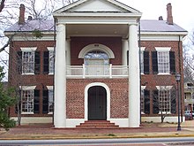
Dahlonega
| Dahlonega | |
|---|---|
| Nickname : Azalea City | |
|
County and state location
|
|
| Basic data | |
| State : | United States |
| State : | Georgia |
| County : | Lumpkin County |
| Coordinates : | 34 ° 32 ′ N , 83 ° 59 ′ W |
| Time zone : | Eastern ( UTC − 5 / −4 ) |
| Residents : | 5,242 (as of 2010) |
| Population density : | 315.8 inhabitants per km 2 |
| Area : | 16.6 km 2 (approx. 6 mi 2 ) of which 16.6 km 2 (approx. 6 mi 2 ) is land |
| Height : | 442 m |
| Postcodes : | 30533, 30597 |
| Area code : | +1 706 |
| FIPS : | 13-21240 |
| GNIS ID : | 0355420 |
| Website : | dahlonega-ga.gov |
| Mayor : | Sam Norton |
Dahlonega is a city and also the county seat of Lumpkin County in the US state of Georgia with 5242 inhabitants (as of 2010).
geography
Dahlonega is about 90 km north of Atlanta in the southern foothills of the Blue Ridge Mountains on the banks of the Chestatee River .
history
The town's name is on the word 'talonega' back what gold in the language of the Cherokee - Indians means. Gold was first discovered south of Dahlonega around 1828, which led to the establishment of a gold mine, the Calhoun Mine , and the first gold rush in Georgia. The city achieved considerable prosperity, which is reflected in the golden roof of the Dahlonega Mint, which is now part of North Georgia College . Dahlonega was the minting location for gold coins from 1838 to 1861 and now houses a gold museum. Gold coins minted in Dahlonega can be recognized by the embossed "D". Gold from Dahlonega, from the Crisson Gold Mine , is also found on the roof of the Georgia State Capitol in Atlanta .
Demographic data
According to the 2010 census, the then 5242 inhabitants were distributed among 1567 inhabited households, which gives an average of 2.27 people per household. There are a total of 1915 households.
52.6% of the households were family households (consisting of married couples with or without offspring or one parent with offspring) with an average size of 2.82 persons. Children under the age of 18 lived in 20.0% of all households and persons aged 65 or over in 28.1% of all households.
29.8% of the population were younger than 20 years, 38.6% were 20 to 39 years old, 14.6% were 40 to 59 years old, and 17.2% were at least 60 years old. The mean age was 23 years. 49.2% of the population were male and 50.8% were female.
91.3% of the population identified themselves as whites , 3.1% as African American , 0.4% as Indians and 1.2% as Asian Americans . 2.2% said they belonged to another ethnic group and 1.9% to several ethnic groups. 6.0% of the population was made up of Hispanics or Latinos .
The average annual income per household was 33,007 USD , while 30.6% of the population lived below the poverty line.
Attractions
The following properties have been entered on the National Register of Historic Places :
traffic
Dahlonega is crossed by US Highway 19 and Georgia State Routes 9 and 52 . The nearest airport is Atlanta Airport (around 110 km southwest).
education
Dahlonega is the seat of the University of North Georgia .
sons and daughters of the town
- William P. Price (1835–1908), politician
Web links
- Website of the city (Engl.)
Individual evidence
- ^ Profile of General Population and Housing Characteristics: 2010 . United States Census Bureau . Retrieved December 22, 2018.
- ↑ GEORGIA - Lumpkin County. National Register of Historic Places , accessed December 22, 2018 .

