US Highway 90
| map | |
|---|---|

|
|
| Basic data | |
| Overall length: | 1633 mi / 2628 km |
| Opening: | 1926 |
| States: |
Florida Alabama Mississippi Louisiana Texas |
| Starting point: |
|
| End point: |
|
| Important cities: |
Jacksonville Tallahassee Pensacola (Florida) Mobile Gulfport New Orleans Houston San Antonio |
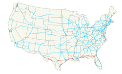
The US Highway 90 (also US Route 90 , just US 90 ) is an important running from west to east highway . The highway is 2,628 km (1,633 mi) long and runs from Jacksonville Beach on the Atlantic coast of Florida to Van Horn in western Texas. The Interstate 10 runs along the entire route at different distances parallel to the highway 90. In spite of the number "0" in the number of Highway no connection from coast to coast.
At the eastern end of Highway 90 is the junction with Florida State Road A1A in Jacksonville Beach. The western end forms the junction with Interstate 10 and Texas State Highway 54 at Van Horn in Texas.
course
Florida
Highway 90 begins in Jacksonville Beach on Florida State Road A1A and leads from there first to the nearby city of Jacksonville, where it crosses Interstate 295 . Further west, the Osceola National Forest is crossed and reaches Lake City . Interstate 75 crosses a few kilometers after the city .
About Live Oak , Madison and Monticello which is capital Tallahassee reached where the US Highway 27 crosses. Behind Tallahassee, Highway 90 crosses the parallel Interstate 10 and runs north of it through the entire Florida Panhandle to Pensacola .
There, Highway 90 splits into Highway 90, which runs through the city, and Alternate US 90 , which forms a northern bypass of the city. After Hurricane Ivan , which destroyed the Interstate 10 bridge, Highway 90 was Pensacola's only connection east.
Highway 90 runs through the administrative cities of all 15 Florida counties it traverses and is never more than ten kilometers from Interstate 10 on its entire route through the state.
Alabama
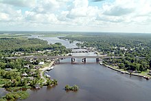
Crossing Alabama on Highway 90 is primarily characterized by passing Mobile Bay on the Cochrane-Africatown USA Bridge . The highway ran through the city of Mobile until the bridge was completed .
Mississippi
Before the passage of Hurricane Katrina , the section of Highway 90 through Mississippi was a very short, four-lane stretch that left the state at the bridge over the Pearl River in the direction of Louisiana. After that, the originally only 42 km long route was greatly extended due to the destruction of many bridges by Hurricane Katrina.
In the meantime, most of the route has been restored with repaired and new bridges, even if not all of the damage has been completely removed.
Louisiana
Immediately after the state line you can reach the suburbs of New Orleans. After crossing downtown, Highway 90 leaves the city on the West Bank Expressway in a southwesterly direction. The highway to Lafayette runs through Morgan City , Franklin and New Iberia . West of Lafayette, Interstate 10 and Highway 90 reach the state of Texas over a bridge behind Lake Charles .
Texas
In Orange , the highway reaches 90 Texas soil. The way to Houston continues via Beaumont , Dayton and Crosby . The Orange section coincides with Interstate 10.
East of Houston, Highway 90 in Harris County is developed as a Crosby Freeway, similar to a freeway.
In Houston, Highway 90 is divided into a route running south as Highway 90 Alternate and the northern actual Highway 90. While the actual route runs parallel to Interstate 10, the alternative route runs through the towns of Rosenberg (where US Highway 59 intersects), Hallettsville, and Gonzales to Seguin . There both routes reunite and lead to San Antonio . From there the highway leads through the sparsely populated west of Texas to its end point at Van Horn.
history
Hurricane Katrina
The bridges between Bay Saint Louis and Pass Christian and between Biloxi and Ocean Springs in Mississippi were destroyed in August 2005 by Hurricane Katrina . The section that runs across Battleship Parkway in Alabama has been badly damaged. In Harrison County , large parts of the highway, including bridges, were destroyed or damaged, and the road bed was partially washed away.
The Rigolets Bridge and the Chef Menteur Bridge in east New Orleans have been destroyed, but have since been repaired. Parts of the highway in the New Orleans metropolitan area had become impassable due to flooding.
In the middle of 2006, construction work began on a new bridge in Bay St. Louis, which was fully accessible again in January 2008. The new 26 m high bridge was partially released in May 2007, which meant the end of temporary ferry traffic.
In June 2006 a decision was made to build a new $ 338.6 million bridge from Biloxi to Ocean Springs. The bridge should be 29 m high, have six lanes and a footpath and bike path. The first partial opening took place in November 2007. The final completion was planned for April 2008.
future
It is planned to expand the section between Lafayette and New Orleans and name Interstate 49 .
Web links
- US-90 photo site by John Preble
- Reconstruction of the Bay Saint Louis Bridge
- Reconstruction of the Biloxi Bridge
Individual evidence
- ↑ Droz, Robert V. US Highways: From US 1 to (US 830) ( Memento of the original from February 15, 2006 in the Internet Archive ) Info: The archive link was inserted automatically and has not yet been checked. Please check the original and archive link according to the instructions and then remove this notice. . URL accessed 22:46, 20 February 2006 (UTC).
- ↑ End of US highway 90. US Ends.com, December 6, 2016, accessed December 27, 2017 .
- ↑ Associated Press : Biloxi Bay Bridge reopens Today (English) , WKRG News. November 1, 2007. Archived from the original on January 24, 2010. Retrieved on January 24, 2010.
- ↑ The Spokes ( Memento of the original from July 21, 2011 in the Internet Archive ) Info: The archive link was inserted automatically and has not yet been checked. Please check the original and archive link according to the instructions and then remove this notice. (PDF; 19.1 MB). Oscar Slotboom, Houston Freeways , houstonfreeways.com. Last Accessed January 27, 2008.
- ^ Work Underway To Rebuild Bay St. Louis Bridge WLOX-TV Biloxi-Gulfport, Mississippi. Posted April 12 2006. Accessed 13 December 2006.
- ↑ Information on the reconstruction of the Bay St. Louis Bridge
- ↑ Section of Katrina-Damaged Hwy 90 Bridge reopens WWL-TV New Orleans, posted May 17, 2007. Accessed May 27, 2007.
- ^ Reconstruction of The Bay St. Louis Bridge ( October 20, 2007 memento in the Internet Archive ) Mississippi Department of Transportation
- ↑ LaFontaine, Ryan; Baker, Margaret; Perez, Mary and Newsom, Michael. Parade marks first vehicles to cross Biloxi Bay Bridge ( Memento of November 4, 2007 in the Internet Archive ) Posted by The Sun Herald online November 1, 2007
- ^ Mississippi Department of Transportation. US 90 Bridge at Biloxi. Retrieved November 11, 2007.


