US Highway 67
| map | |
|---|---|

|
|
| Basic data | |
| Overall length: | 1560 mi / 2511 km |
| Opening: | 1926 |
| States: |
Texas Arkansas Missouri Illinois Iowa |
| Starting point: |
|
| End point: |
|
| Important cities: |
San Angelo , TX Dallas , TX Texarkana, TX / Texarkana, AR Little Rock , AR St. Louis , MO Quad Cities , IL / IA |
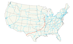
The US Highway 67 runs from the southwest in the Midwest of the United States . It runs about 2,511 km from its southwestern end point in Presidio County at the bridge over which the Mexican border forming Rio Grande in Presidio , Texas until his northeastern end point in Sabula in Jackson County in Iowa . There, the Highway 67 near the ends Savavanna Sabula Bridge in the US Highway 52 .
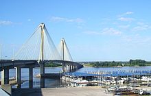
Highway 67 crosses the Mississippi River twice in its course . The first river crossing is around 30 km north of the city of St. Louis from West Alton in Missouri over the Clark Bridge to Alton in Illinois . In the Quad Cities 390 km to the north, the Rock Island Centennial Bridge runs from Rock Island in Illinois to Davenport in Iowa . In addition, Highway 67 crosses the Missouri River over the Lewis Bridge on the northern outskirts of St. Louis, which is about seven kilometers from the Clark Bridge .
course
Texas
Through Texas, Highway 67 runs more west-east, although odd-numbered US highways tend to run north-south (or vice versa). However, as a whole, the highway takes a south-north course on its way through five states .
The Highway 67 leads from Presidio in a northeast direction to Interstate 10 and leads with this in an easterly direction to Fort Stockton . A few kilometers after the city, Highway 67 turns northeast from the interstate to San Angelo . In the further course of the US Highway 83 is crossed in Ballinger until the city of Coleman is reached. Here the US Highway 283 crosses and further eastwards the Highway 67 leads together with the US Highway 84 to Brownwood . From here on, Highways 67 and 377 run together and cross US Highway 281 in Stephenville and after Cleburne crosses the western branch of Interstate 35 (called Interstate 35W ) before arriving in Dallas from the southwest . There, Highway 67 meets Interstate 20 , Interstate 30 , the eastern branch of Interstate 35 (called Interstate 35E ) and Interstate 635, as well as US Highways 75 , 77 and 80 .
Highway 67 now runs east and northeast together with Interstate 30 past the city of Greenville to Sulfur Springs , before the two roads separate again a few kilometers east, but run parallel. Via Mount Pleasant and the junction with US Highway 259 , Highway 67 then reaches the border between the states of Texas and Arkansas in the twin cities of Texarkana, Texas and Texarkana, Arkansas . In Texarkana, Highway 67 meets US Highways 59 , 71 and 82 .
Arkansas
The Red River is crossed around 30 km northeast of Texarkana . Via Hope with the intersection of US Highway 278 , Prescott , Gurdon , Arkadelphia and Malvern with the intersection of US Highway 270 , Highway 67 runs parallel to Interstate 30 to run together with this from Benton and to reach Little Rock . There, Highway 67 meets Interstate 40 and US Highways 65 , 70 , 165, and 167 .
Via North Little Rock , Highways 67 and 167 continue together in a north-easterly direction on a four-lane route. The cities of Jacksonville , Cabot , Beebe (from where the US Highway 64 runs on the common route), Searcy will be passed before the highways 64 and 167 branch off in Bald Knob . A little later the White River is crossed on the four-lane route in a north-easterly direction . The four-lane section ends at Newport and Highway 67 reaches US Highways 63 and 412 in Walnut Ridge . The rest of the route now runs due north to Pocahontas , where a bridge crosses the Black River . This is where Highways 62 and 67 meet and run in a north-easterly direction before Highway 62 branches off again in an easterly direction in Corning . 12 km further northeast, the border between the states of Arkansas and Missouri is reached.
Missouri
After Highway 62 has reached US Highway 160 after 16 km, coming from the southwest of Arkansas , it leads together with this to the northeast. Highway 160 branches off to this city five kilometers before Poplar Bluff . Highway 67 now leads north and, together with US Highway 60 coming from Popular Bluff, reaches the Mark Twain National Forest on an approximately ten kilometer long four-lane section . After a few kilometers, Highway 60 branches off to the west again. Missouri State Route 34 crosses behind Greenville and Missouri State Route 72 near Fredericktown to the north of it . In the further course the Missouri State Route 32 is reached near Farmington , which runs together with Highway 67 to Park Hills . Via Bonne Terre with the junction of Missouri State Route 47 , Highway 67 reaches the Mississippi in Festus . There, on the southwestern outskirts, Interstate 55 is crossed and US Highway 61 is reached shortly thereafter . From now on both run together in a northerly direction parallel to Interstate 55 and the Mississippi. In Arnold , the suburban area of St. Louis is now reached. The route between Festus St. Louis, which runs through Jefferson County , is therefore also called Jeffco Boulevard .
St. Louis County
By the St. Louis County Highway 67 crosses the Lemay Ferry Road ( Missouri State Route 267 ) and Lindbergh Boulevard . Kirkwood is reached via this . Further north crosses Interstate 64 , from where on Highway 67 again leads through the village of Ladue . Further north, after passing under the airport, the northern outskirts of St. Louis are reached. Highway 67 now runs through Florissant and crosses the Missouri River over the Lewis Bridge . A few kilometers further north is the Clark Bridge , which leads over the Mississippi to Alton in Illinois .
Through the only road tunnel in the state of Missouri, Highway 67 runs under the runways of Lambert-St. Louis International Airport.
Illinois
In Illinois, Highway 67 leads from Alton through the westernmost region of the state called Forgottonia , which is formed by an arch of the Mississippi River. The road runs north and northeast via Jerseyville to Jacksonville , where the road bends northwest. About 5 km west of Meredosia at the intersection with Illinois State Routes 100 and 104 , the course changes again in a northerly direction and now runs about two kilometers away from the Illinois River . In Beardstown , Highway 67 crosses the Illinois River and now runs straight north through the towns of Macomb and Monmouth . Further north is before reaching rock Iceland the Interstate 280 crosses under. Highway 67 leaves Illinois for Iowa over the Rock Island Centennial Bridge over the Mississippi .
Iowa
In Davenport , Highway 67 reaches the state of Iowa over the Rock Island Centennial Bridge . From then on, Highway 67 runs parallel to the Mississippi in an easterly direction. First the Interstate 74 is crossed and the town of Bettendorf is reached, on the eastern edge of which Interstate 80 crosses. In the further, now predominantly northern course, Clinton is reached, where US Highway 30 crosses. Highway 67 ends 27 km north of Clinton at the confluence with US Highway 52 near the town of Sabula .
history
- When Highway 67 was established in 1926, it ran from Dallas , Texas to Fredericktown , Missouri.
- In 1930 the expansion took place at its current southwestern end point on the border with Mexico .
- In 1932, the north end was moved north to Rock Island , Illinois.
- In 1934 the highway was extended to Dubuque , Iowa, even further north .
- In 1967 the northern end point was determined at Sabula, Iowa.
Web links
- US-67 info
- US highways endpoints
- Illinois US 67 story
- IL Corridor 67 - 2006
- Centennial Bridge
- Illinois Highway Ends: US 67
- Another Mother Road
Individual evidence
- ↑ US Highways ( Memento of the original of May 13, 2007 in the Internet Archive ) Info: The archive link was automatically inserted and not yet checked. Please check the original and archive link according to the instructions and then remove this notice.


