Alton (Illinois)
| Alton | ||
|---|---|---|
|
Location in Illinois
|
||
| Basic data | ||
| Foundation : | 1837 | |
| State : | United States | |
| State : | Illinois | |
| County : | Madison County | |
| Coordinates : | 38 ° 54 ′ N , 90 ° 10 ′ W | |
| Time zone : | Central ( UTC − 6 / −5 ) | |
| Residents : | 27,865 (as of 2010) | |
| Population density : | 648 inhabitants per km 2 | |
| Area : | 43 km 2 (approx. 17 mi 2 ) | |
| Height : | 150 m | |
| Postal code : | 62002 | |
| Area code : | +1 618 | |
| FIPS : | 17-01114 | |
| GNIS ID : | 403470 | |
| Website : | www.alton-il.com | |
| Mayor : | Tom Hoechst | |
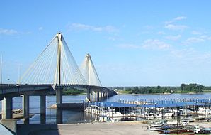
 Clark Bridge from Alton, Illinois to West Alton, Missouri |
||
Alton is a town (with the status " City ") in Madison County in the west of the US -amerikanischen state of Illinois . In 2010 Alton had 27,865 inhabitants.
The city is located in the eastern part of the Greater St. Louis metropolitan area called Metro-East around the city of St. Louis in neighboring Missouri .
geography
Alton is on the left bank of the Mississippi , which forms the border with the state of Missouri. Alton is located between the mouth of the Illinois River (15 miles above at Grafton ) and the Missouri River (on the opposite bank about five kilometers below).
Alton is located at 38 ° 54'02 "north latitude and 90 ° 09'35" west longitude and extends over 43 km², which is spread over 40 km² of land and 3 km² of water. The city of Alton is identical to the Alton Township .
Neighboring towns are Elsah (18.6 km west-northwest), Godfrey (8.5 km north), Bethalto (14.9 km east-northeast) and East Alton (6.6 km east). On the opposite bank of the Mississippi is West Alton (8.8 km southwest). Downtown St. Louis is 22 miles south.
traffic
From Alton, the Clark Bridge , over which US Highway 67 runs, leads south across the Mississippi to St. Louis. Through the city here the Illinois portion of the lead along the Mississippi Great River Road forming Illinois State Highway 100 and 143 . The Illinois State Routes 3 , 111 and 140 also meet in the urban area . All other roads are county roads and suburban interconnecting roads.
Several lines from various railway companies meet in Alton to run together to St. Louis. There is an Amtrak station within the city for long-distance passenger transport .
The St. Louis Regional Airport is 13.9 km west, the larger Lambert-Saint Louis International Airport is 35.9 km southwest of Alton.
Demographic data
According to the 2010 census , Alton had 27,865 people in 11,734 households. The population density was 648 inhabitants per square kilometer. Statistically, 2.33 people lived in each of the 11,734 households.
The racial the population was composed of 68.5 percent white, 29.6 percent African American, 0.2 percent Native American, 0.5 percent Asian and 0.5 percent from other ethnic groups; 3.7 percent were descended from two or more races. Hispanic or Latino of any race was 1.9 percent of the population.
24.1 percent of the population were under 18 years old, 62.0 percent were between 18 and 64 and 13.9 percent were 65 years or older. 52.2 percent of the population was female.
The average annual income for a household was 37,447 USD . The per capita income was $ 18,945. 25.0 percent of the population lived below the poverty line.
sons and daughters of the town
- Theodore P. Gilman (1841–1930), banker and politician
- Robert Wadlow (1918–1940), the tallest person in medical history, whose height is clearly documented
- Mary Beth Hughes (1919–1995), actress
- Miles Davis (1926–1991), jazz trumpeter
- James Earl Ray (1928–1998), murderer of Martin Luther King
- Howard Williams (1929 / 30–2018), jazz musician
- Kash Killion , jazz bassist
- Edward Joseph Weisenburger (* 1960), Roman Catholic clergyman and Bishop of Tucson
- Ezekiel Elliott (born 1995), football player
Individual evidence
- ↑ Mayor ( Memento of the original from March 1, 2010 in the Internet Archive ) Info: The archive link was inserted automatically and has not yet been checked. Please check the original and archive link according to the instructions and then remove this notice.
- ^ A b American Fact Finder. Retrieved July 2, 2012
- ↑ Distance information according to Google Maps. Accessed July 2, 2012

