Greater St. Louis
The Greater St. Louis region is the metropolitan area around the city of St. Louis , Missouri . This region stretches on both sides of the Mississippi River , which forms the border between Missouri and Illinois . The eastern part of the region in Illinois is called Metro-East .
The entire region had 2,828,990 inhabitants at the 2000 census , this number rose slightly in the 2010 census to 2,830,355 in the "Metropolitan Census Area" (MSA), in the Combined Statistical Area (CSA) the number rose to 2,878 .255 at.
geography
The Greater St. Louis region lies on both sides of the Mississippi, into which the Missouri flows north of downtown St. Louis . The area covers an area of 22,910 km².
Counties
The region consists of the following counties in Missouri and Illinois: (The data are from 2008)
| county | Residents | Changes 1990-2000 | Ew. per km² | Land area in km² |
|---|---|---|---|---|
| St. Louis County, MO | 991.830 | 2.3% | 753 | 1,316 |
| St. Louis City, MO | 356.361 | −12.2% | 2,204 | 161 |
| St. Charles County, MO | 349,407 | 33.4% | 241 | 1,450 |
| Madison County, IL | 267.038 | 3.9% | 142 | 1,878 |
| St. Clair County, IL | 261,409 | −2.6% | 152 | 1,720 |
| Jefferson County, MO | 217,679 | 15.6% | 128 | 1,702 |
| Franklin County, MO | 100,898 | 16.4% | 42 | 2,391 |
| Lincoln County, MO | 52,775 | 34.8% | 32 | 1,632 |
| Macoupin County, IL | 48.143 | 2.8% | 55 | 2,247 |
| Clinton County, IL | 36,470 | 4.7% | 30th | 1,228 |
| Monroe County, IL | 32,335 | 23.2% | 32 | 1.005 |
| Warren County, MO | 31,214 | 25.6% | 28 | 1,116 |
| Washington County, MO | 24,548 | 2.5% | 12 | 1,975 |
| Jersey County, IL | 22,451 | 5.5% | 23 | 956 |
| Bond County, IL | 18,253 | 1.3% | 18th | 991 |
| Calhoun County, IL | 5.101 | −4.5% | 7th | 735 |
Major cities and towns
- Franklin County MO: : Berger , Gerald , New Haven , Pacific , Saint Clair , Sullivan , Union , Washington
- Jefferson County MO: Arnold , Barnhart , Byrnes Mill , Crystal City , De Soto , Festus , Herculaneum , Hillsboro , Pevely
- Lincoln County MO: Elsberry , Moscow Mills , Old Monroe , Troy , Winfield
- St. Charles County MO: : Cottleville , Dardenne Prairie , Foristell , (partly.) Lake St. Louis , O'Fallon , St. Charles , Saint Peters , Weldon Spring , Wentzville
- St. Louis City (separate city)
- St. Louis County MO: Affton , Ballwin , Berkeley , Black Jack , Breckenridge Hills , Bridgeton , Charlack , Chesterfield , Clayton , Cool Valley , Crestwood , Creve Coeur , Des Peres , Edmundson , Ferguson , Fenton , Florissant , Hazelwood , Kinloch , Kirkwood , Jennings , Ladue , Maryland Heights , Mehlville , Olivette , Overland , Rock Hill , St. Ann , St. John , Sunset Hills , Spanish Lake , University City , Webster Groves , Wellston , Wildwood
- Warren County MO: Foristell ( partially ), Marthasville , Truesdale , Warrenton , Wright City
- Bond County IL: Greenville
- Calhoun County IL: Hardin , Kampsville
- Clinton County IL: Carlyle , Centralia (partially), Germantown , New Baden
- Jersey County IL: Brighton (partially), Jerseyville , Grafton
- Macoupin County IL: Brighton (partially), Carlinville , Staunton
- Madison County IL: Alton , Collinsville , Edwardsville , Glen Carbon , Granite City , Highland , Troy , Wood River
- St. Clair County IL: Belleville , Cahokia , Caseyville , East St. Louis , Fairview Heights , Lebanon , O'Fallon , Shiloh
traffic
Rail transport
The St. Louis area, particularly the city of East St. Louis, has historically been one of the largest railroad hubs in the country. Even today, a number of railway lines for freight (e.g. Union Pacific , CSX , BNSF ) and passenger (e.g. Amtrak ) meet in the region.
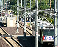
Public transport in the St. Louis region is to a large extent by the Metrolink mentioned train taken.
Trunk roads
Colleges


Around 209,000 students are enrolled at around 40 colleges , universities or technical colleges in the region. The most famous and largest educational institutions in the region are the state University of Missouri – St. Louis as well as the private Saint Louis University (the oldest west of the Mississippi) and Washington University in St. Louis .
There are also Webster University in Webster Groves, Maryville University in Town and Country and Fontbonne University in Clayton in St. Louis County . In the city of St. Louis there is Harris – Stowe State University .
In Illinois, there is Southern Illinois University in Edwardsville, Madison County . Smaller colleges in Metro-East are McKendree University in Lebanon in St. Clair County and Greenville College in Greenville in Bond County.

