Saint Charles (Missouri)
| Saint Charles | |
|---|---|
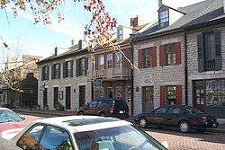
 Historic Main Street of St. Charles |
|
| Location in Missouri | |
| Basic data | |
| Foundation : | 1769 |
| State : | United States |
| State : | Missouri |
| County : | St. Charles County |
| Coordinates : | 38 ° 47 ′ N , 90 ° 31 ′ W |
| Time zone : | Central ( UTC − 6 / −5 ) |
| Residents : | 65,794 (as of 2010) |
| Population density : | 1,248.5 inhabitants per km 2 |
| Area : | 54.0 km 2 (approx. 21 mi 2 ) of which 52.7 km 2 (approx. 20 mi 2 ) are land |
| Height : | 150 m |
| Postal code : | 63301 |
| Area code : | +1 636 |
| FIPS : | 29-64082 |
| GNIS ID : | 756631 |
| Website : | www.stcharlescitymo.gov |
| Mayor : | Sally Faith (since 2011) |
Saint Charles is a city in the US state of Missouri with a population of 68,341 (2016 estimate) . It is located 30 km northwest of St. Louis in the metropolitan area and is the capital of St. Charles County .
history
Saint Charles, founded in 1769, is one of the oldest cities west of the Mississippi. The name is the English form of San Carlos Borromeo . The first church that Spanish settlers built here at the end of the 18th century was dedicated to this Italian saint. From 1821 to 1826, the city was Missouri's first official capital . The First Missouri State Capitol State Historic Site still bears witness to this in the present .
The start of the Katy Trail State Park , a 360 km long hiking route on a former railway line, is also located in Saint Charles .
Town twinning
Saint Charles has two twin cities: the German city of Ludwigsburg in Baden-Württemberg and the Irish city of Carndonagh in County Donegal .
Born in Saint Charles
- Frederick Weygold (1870–1941), painter, photographer and ethnographer
- Jeanne Shaheen (* 1947), politician of the Democratic Party
- Connie Price-Smith (* 1962), shot put and discus thrower
- Mark Buehrle (* 1979), baseball player
- Brad Davis (born 1981), football player
- Brandon Bollig (* 1987), ice hockey player
Web links
proof
- ↑ City website - Mayor , accessed February 28, 2018
- ^ American FactFinder - Saint Charles , accessed February 28, 2018
- ↑ site Saint Chartles - Sister Cities Program , accessed on February 28, 2018
