O'Fallon, Missouri
| O'Fallon | |
|---|---|
|
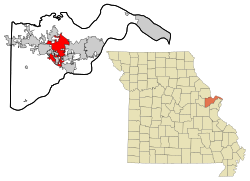
Location in Missouri
|
|
| Basic data | |
| Foundation : | 1856 |
| State : | United States |
| State : | Missouri |
| County : | St. Charles County |
| Coordinates : | 38 ° 47 ′ N , 90 ° 42 ′ W |
| Time zone : | Central ( UTC − 6 / −5 ) |
| Residents : | 82,809 (as of 2013) |
| Population density : | 1,422.8 inhabitants per km 2 |
| Area : | 58.2 km 2 (approx. 22 mi 2 ) of which 58.2 km 2 (approx. 22 mi 2 ) are land |
| Height : | 165 m |
| Postcodes : | 63366, 63368 |
| Area code : | +1 636 |
| FIPS : | 29-54074 |
| GNIS ID : | 0756460 |
| Website : | www.ofallon.mo.us |
| Mayor : | Bill Hennessy |
O'Fallon is a town (with the status " City ") in St. Charles County in the eastern part of the US -amerikanischen state of Missouri . At the 2013 census , the city had 82,809 inhabitants.
The city of O'Fallon is part of the Greater St. Louis metropolitan area .
geography
The city of O'Fallon is located in the east of the state of Missouri between the Missouri (about 16 km south) and the Mississippi (about 17 km north) about 60 km west of the confluence of the two rivers.
O'Fallon covers an area of 11.31 km².
Neighboring towns are Lake St. Louis (6.3 km west), Saint Peters (13.9 km east), Cottleville (8.6 km east-northeast), and New Melle (19.1 km southwest).
The closest major cities are St. Louis (36 miles east) and Missouri's capital, Jefferson City (163 miles west).
history
In O'Fallon , the congregation of the Sisters of the Most Precious Blood of O'Fallon was founded in 1870 by German and Swiss nuns who, due to the looming culture war, could not count on being able to return home in the foreseeable future ( Order abbreviation : CPPS, also called Sisters of the Most Precious Blood of O'Fallon after the place of origin ).
traffic
Several highways run through the town, including Interstates 64 and 70 and a number of secondary roads.
Demographic data
| Population development | |||
|---|---|---|---|
| Census | Residents | ± in% | |
| 1920 | 588 | - | |
| 1930 | 594 | 1 % | |
| 1940 | 618 | 4% | |
| 1950 | 789 | 27.7% | |
| 1960 | 3770 | 377.8% | |
| 1970 | 7018 | 86.2% | |
| 1980 | 8677 | 23.6% | |
| 1990 | 18,698 | 115.5% | |
| 2000 | 46.169 | 146.9% | |
| 2010 | 79,329 | 71.8% | |
According to the 2010 census , O'Fallon had 79,329 people in 26,359 households. The population density was 1363 inhabitants per square kilometer.
The racial the population was composed of 89.9 percent white, 4.0 percent African American, 0.2 percent Native American, 3.2 percent Asian and other ethnic groups; 1.8 percent were descended from two or more races. Hispanic or Latino of any race was 2.7 percent of the population.
Statistically, 2.82 people lived in each of the 26,359 households.
30.0 percent of the population were under 18 years old, 61.1 percent were between 18 and 64 and 8.9 percent were 65 years or older. 51.2 percent of the population was female.
The median income for a household was 76,839 USD . The per capita income was $ 29,778. 3.5 percent of the population lived below the poverty line.
Personalities
sons and daughters of the town
- Josh Sargent (* 2000), soccer player
Individual evidence
- ↑ a b U.S. Census Bureau, State & County QuickFacts - O'Fallon, MO ( Memento of the original from September 6, 2012 in the Internet Archive ) Info: The archive link was automatically inserted and not yet checked. Please check the original and archive link according to the instructions and then remove this notice. Retrieved March 17, 2012
- ↑ Distance information according to Google Maps. Accessed on March 17, 2012
- ^ Walter Williams: A History of Northeast Missouri . The Lewis Publishing Company, Chicago 1913, p. 97.
