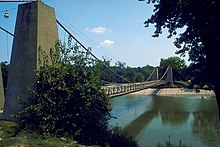
Clinton County (Illinois)
 Clinton County Courthouse |
|
| administration | |
|---|---|
| US state : | Illinois |
| Administrative headquarters : | Carlyle |
| Address of the administrative headquarters: |
County Courthouse P.O. Box 308 Carlyle, IL 62231-0308 |
| Foundation : | December 27, 1824 |
| Made up from: |
Washington County , Bond County , Fayette County |
| Area code : | 001 618 |
| Demographics | |
| Residents : | 37,762 (2010) |
| Population density : | 30.8 inhabitants / km 2 |
| geography | |
| Total area : | 1304 km² |
| Water surface : | 76 km² |
| map | |
| Website : www.clintonco.illinois.gov | |
The Clinton County is a county in the US -amerikanischen State Illinois . In 2010 , the county had 37,762 residents and a population density of 30.8 people per square kilometer. The county seat is Carlyle . The largest local recreation area is Carlyle Lake and its immediate surroundings.
Clinton County is located in the eastern part of the Greater St. Louis metropolitan area known as Metro-East around the city of St. Louis in neighboring Missouri .
geography
The county is located in southern Illinois and has an area of 1,304 square kilometers, of which 76 square kilometers are water.
Carlyle Lake, which was created by damming the Kaskaskia River , is the largest reservoir in Illinois, mainly in Clinton County .
The following neighboring counties border Clinton County:
| Madison County | Bond County | Fayette County |
| St. Clair County |

|
Marion County |
| Washington County |
history
The first settlement took place in 1811 by a Mister Hill. The Hill Log House was the first registered building and stood on the site of what is now Carlyle. The Goshen Trace , an old Indian trail , led through the country to a salt mine. When the first paved road from Vincennes to St. Louis was built in 1820, she used this path as a foundation. Hill was also the first to introduce ferry services across the Kaskaskia River. In 1817 more settlers were added and in 1824 1,100 people are said to have lived here, 137 of them in Carlyle.
On December 27, 1814, the county was formed from parts of Washington, Bond and Fayette Counties and named after DeWitt Clinton , a mayor of New York and later governor of New York state.
In 1857 a railway line was laid in the area by the Ohio and Mississippi Railroad and by 1878 several thousand people were already living in the county. The next leap in settlement began in 1911 with the oil boom.
Demographic data
| Population development | |||
|---|---|---|---|
| Census | Residents | ± in% | |
| 1830 | 2330 | - | |
| 1840 | 3718 | 59.6% | |
| 1850 | 5139 | 38.2% | |
| 1860 | 10,941 | 112.9% | |
| 1870 | 16,285 | 48.8% | |
| 1880 | 18,714 | 14.9% | |
| 1890 | 17,411 | -7% | |
| 1900 | 19,824 | 13.9% | |
| 1910 | 22,832 | 15.2% | |
| 1920 | 22,947 | 0.5% | |
| 1930 | 21,369 | -6.9% | |
| 1940 | 22,912 | 7.2% | |
| 1950 | 22,594 | -1.4% | |
| 1960 | 24,029 | 6.4% | |
| 1970 | 28,315 | 17.8% | |
| 1980 | 32,617 | 15.2% | |
| 1990 | 33,944 | 4.1% | |
| 2000 | 35,535 | 4.7% | |
| 2010 | 37,762 | 6.3% | |
| Before 1900 1900–1990 2000 2010 | |||

As of the 2010 census , Clinton County had 37,762 people in 13,871 households. The population density was 30.8 inhabitants per square kilometer. Statistically, 2.41 people lived in each of the 13,871 households.
The racial the population was composed of 93.4 percent white, 3.5 percent African American, 0.2 percent Native American, 0.4 percent Asian and other ethnic groups; 1.1 percent were descended from two or more races. Regardless of ethnicity, 2.8 percent of the population was Hispanic or Latino of any race.
22.7 percent of the population were under 18 years old, 62.2 percent were between 18 and 64 and 15.1 percent were 65 years or older. 48.2 percent of the population was female.
The median income for a household was 53,873 USD . The per capita income was $ 24,722. 8.4 percent of the population lived below the poverty line.
Clinton County localities
1 - partly in Washington , Jefferson and Marion County
2 - partly in Bond County
3 - partly in St. Clair County
structure
Clinton County is divided into 15 townships :
|
|
See also
Individual evidence
- ↑ GNIS-ID: 424215. Retrieved on February 22, 2011 (English).
- ↑ a b c U.S. Census Bureau, State & County QuickFacts - Clinton County, IL Retrieved November 22, 2012
- ^ A b National Association of Counties. Retrieved November 22, 2012
- ^ US Census Bureau - Census of Population and Housing.Retrieved March 15, 2011
- ↑ Extract from Census.gov.Retrieved on February 14, 2011
- ^ Extract from the National Register of Historic Places.Retrieved March 13, 2011
- ↑ Missouri Census Data Center - Illinois ( page no longer available , search in web archives ) Info: The link was automatically marked as defective. Please check the link according to the instructions and then remove this notice. Retrieved November 22, 2012
Web links
Coordinates: 38 ° 37 ′ N , 89 ° 25 ′ W


