
Johnson County (Illinois)
 Johnson County Courthouse |
|
| administration | |
|---|---|
| US state : | Illinois |
| Administrative headquarters : | Vienna |
| Address of the administrative headquarters: |
Johnson County Courthouse 400 Court Sq. PO Box 96 Vienna, IL 62995 |
| Foundation : | September 14, 1812 |
| Made up from: | Randolph County |
| Area code : | 001 618 |
| Demographics | |
| Residents : | 12,582 (2010) |
| Population density : | 14.1 inhabitants / km 2 |
| geography | |
| Total area : | 904 km² |
| Water surface : | 11 km² |
| map | |
 |
|
The Johnson County is a county in the US -amerikanischen State Illinois . In 2010 , the county had 12,582 people and a population density of 14.1 people per square kilometer. The county seat is Vienna .
geography
The county is located in southern Illinois and has an area of 904 square kilometers, of which eleven square kilometers are water. The following neighboring counties border Johnson County:
| Williamson County | Saline County | |
| Union County |
.svg)
|
Pope County |
| Pulaski County | Massac County |
history

Johnson County was formed on September 14, 1812 from parts of Randolph County , but is one of the 15 original counties of the Illinois Territory.
It was named after Richard M. Johnson (1780 or 1781–1850), an officer in the War of 1812 , US Senator from Kentucky (1819–1829) and the ninth Vice President of the United States (1837–1841).
The first seat of the county administration was in the house of John Bradshaw (1813-1814), then it was Elvira (1814-1818) before it was 1818 Vienna.
Territorial development

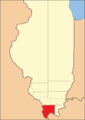
Johnson County from its founding in 1812 to 1816
1816 to 1818
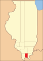
1818 to 1843
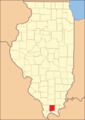
1843 until today


Demographic data
| Population development | |||
|---|---|---|---|
| Census | Residents | ± in% | |
| 1820 | 843 | - | |
| 1830 | 1596 | 89.3% | |
| 1840 | 3626 | 127.2% | |
| 1850 | 4114 | 13.5% | |
| 1860 | 9342 | 127.1% | |
| 1870 | 11,248 | 20.4% | |
| 1880 | 13,078 | 16.3% | |
| 1890 | 15,013 | 14.8% | |
| 1900 | 15,667 | 4.4% | |
| 1910 | 14,331 | -8.5% | |
| 1920 | 12,022 | -16.1% | |
| 1930 | 10,203 | -15.1% | |
| 1940 | 10,727 | 5.1% | |
| 1950 | 8729 | -18.6% | |
| 1960 | 6928 | -20.6% | |
| 1970 | 7550 | 9% | |
| 1980 | 9624 | 27.5% | |
| 1990 | 11,347 | 17.9% | |
| 2000 | 12,878 | 13.5% | |
| 2010 | 12,582 | -2.3% | |
| Before 1900 1900–1990 2000 2010 | |||
As of the 2010 census , Johnson County had 12,582 people in 4,396 households. The population density was 14.1 people per square kilometer. Statistically, 2.24 people lived in each of the 4,396 households.
The racial the population was composed of 89.9 percent white, 8.5 percent African American, 0.4 percent Native American, 0.2 percent Asian and other ethnic groups; 1.0 percent were descended from two or more races. Hispanic or Latino of any race was 3.1 percent of the population.
18.8 percent of the population were under 18 years old, 63.6 percent were between 18 and 64 and 17.6 percent were 65 years or older. 44.2 percent of the population was female.
The median income for a household was 41,619 USD . The per capita income was $ 16,402. 13.6 percent of the population lived below the poverty line.
Johnson County localities
structure
Johnson County is divided into 17 precincts :
| district | Population (2010) | FIPS |
|---|---|---|
| Belknap precinct | 245 | 17-90346 |
| Bloomfield precinct | 922 | 17-90450 |
| Burnside precinct | 516 | 17-90558 |
| Cache precinct | 593 | 17-90594 |
| Elvira precinct | 820 | 17-91188 |
| Goreville No. 1 precinct | 1500 | 17-91440 |
| Goreville No. 2 precinct | 528 | 17-91458 |
| Grantsburg No. 1 precinct | 1915 | 17-91512 |
| Grantsburg No. 2 precinct | 296 | 17-91530 |
| Lake No. 1 precinct | 885 | 17-91840 |
| Lake No. 2 precinct | 457 | 17-91842 |
| Ozark precinct | 545 | 17-92340 |
| Simpson precinct | 582 | 17-93168 |
| Tunnel Hill precinct | 619 | 17-93456 |
| Vienna No. 1 precinct | 515 | 17-93528 |
| Vienna No. 2 precinct | 937 | 17-93546 |
| Vienna No. 3 precinct | 707 | 17-93552 |
See also
Individual evidence
- ↑ GNIS-ID: 424245. Retrieved on February 22, 2011 (English).
- ↑ a b c U.S. Census Bureau, State & County QuickFacts - Johnson County, IL ( Memento of the original from July 12, 2011 on WebCite ) Info: The archive link was automatically inserted and not yet checked. Please check the original and archive link according to the instructions and then remove this notice. Retrieved December 11, 2012
- ↑ a b National Association of Counties. Retrieved December 11, 2012
- ^ US Census Bureau - Census of Population and Housing.Retrieved March 15, 2011
- ^ Extract from Census.gov.Retrieved February 15, 2011
- ↑ Missouri Census Data Center - Illinois ( page no longer available , search in web archives ) Info: The link was automatically marked as defective. Please check the link according to the instructions and then remove this notice. Retrieved August 1, 2012
Web links
List of counties in Illinois
Adams |
Alexander |
Bond |
Boone |
Brown |
Bureau |
Calhoun |
Carroll |
Cass |
Champaign |
Christian |
Clark |
Clay |
Clinton |
Coles |
Cook |
Crawford |
Cumberland |
DeKalb |
DeWitt |
Douglas |
DuPage |
Edgar |
Edwards |
Effingham |
Fayette |
Ford |
Franklin |
Fulton |
Gallatin |
Greene |
Grundy |
Hamilton |
Hancock |
Hardin |
Henderson |
Henry |
Iroquois |
Jackson |
Jasper |
Jefferson |
Jersey |
Jo Daviess |
Johnson |
Kane |
Kankakee |
Kendall |
Knox |
LaSalle |
Lake |
Lawrence |
Lee |
Livingston |
Logan |
Macon |
Macoupin |
Madison |
Marion |
Marshall |
Mason |
Massac |
McDonough |
McHenry |
McLean |
Menard |
Mercer |
Monroe |
Montgomery |
Morgan |
Moultrie |
Ogle |
Peoria |
Perry |
Piatt |
Pike |
Pope |
Pulaski |
Putnam |
Randolph |
Richland |
Rock Island |
Saline |
Sangamon |
Schuyler |
Scott |
Shelby |
St. Clair |
Strong |
Stephenson |
Tazewell |
Union |
Vermilion |
Wabash |
Warren |
Washington |
Wayne |
White |
Whiteside |
Will |
Williamson |
Winnebago |
Woodford
Coordinates: 37 ° 28 ′ N , 88 ° 52 ′ W