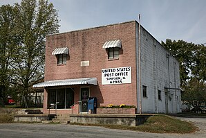
Simpson (Illinois)
| Simpson | ||
|---|---|---|
 Post office in Simpson |
||
| Location in Illinois | ||
|
|
||
| Basic data | ||
| State : | United States | |
| State : | Illinois | |
| County : | Johnson County | |
| Coordinates : | 37 ° 28 ′ N , 88 ° 45 ′ W | |
| Time zone : | Central ( UTC − 6 / −5 ) | |
| Residents : | 60 (as of 2010) | |
| Population density : | 60 inhabitants per km 2 | |
| Area : | 1 km 2 (approx. 0 mi 2 ) | |
| Height : | 118 m | |
| Postal code : | 62985 | |
| Area code : | +1 618 | |
| FIPS : | 17-70005 | |
| GNIS ID : | 418528 | |
Simpson is a small town (with the status " Village ") in Johnson County in southern US -amerikanischen state of Illinois . In 2010 , Simpson had 60 residents.
geography
Simpson lies at 37 ° 28'02 "north latitude and 88 ° 45'18" west longitude and covers an area of one square kilometer. The place is about 30 km north of the Ohio River , which forms the border with Kentucky. The Mississippi , which separates Illinois from Missouri , is about 55 km to the west. The Indiana border is around 100 km northeast. Simson is on the western edge of the Shawnee National Forest .
Neighboring towns to Simpson are Tunnel Hill (12.3 km northwest), Eddyville (17.3 km east-northeast), Wartrace (15.1 km south) and Vienna (15.1 km southwest).
The closest major cities are St. Louis , Missouri (221 km northwest), Louisville , Kentucky (333 km east-northeast), Tennessee's capital Nashville (277 km southeast), and Tennessee's largest city, Memphis (328 km southwest).
traffic
The Illinois State Route 147 runs through the center of Simpson in a west-east direction and also forms the town's main street. All other roads are subordinate routes or inner-city connecting roads.
The Metropolis Municipal Airport is a small airfield 46 km south of Simpson. The nearest major airports are Lambert-Saint Louis International Airport (150 miles northwest), Nashville International Airport (286 miles southeast), and Memphis International Airport (346 miles southwest).
Demographic data
According to the 2010 census , Simpson had 60 people in 20 households. The population density was 60 inhabitants per square kilometer. Statistically, 3 people lived in each of the 20 households.
Ethnically, the population consisted only of whites with one exception.
35.0 percent of the population were under 18 years old, 51.7 percent were between 18 and 64 and 13.3 percent were 65 years or older. 50 percent of the population was female.
The average annual income for a household was 43,281 USD . The per capita income was $ 11,730. 8.7 percent of the population lived below the poverty line.
Individual evidence
- ^ A b American Fact Finder. Retrieved August 2, 2012
- ↑ Distance information according to Google Maps. Accessed on August 2, 2012
