
Massac County
 The Massaac County Courthouse in Metropolis |
|
| administration | |
|---|---|
| US state : | Illinois |
| Administrative headquarters : | Metropolis |
| Address of the administrative headquarters: |
County Courthouse P.O. Box 429 Metropolis, IL 62960-0429 |
| Foundation : | February 8, 1843 |
| Made up from: |
Pope County Johnson County |
| Area code : | 001 618 |
| Demographics | |
| Residents : | 15,429 (2010) |
| Population density : | 24.9 inhabitants / km 2 |
| geography | |
| Total area : | 627 km² |
| Water surface : | 8 km² |
| map | |
 |
|
The Massac County is a county in the US -amerikanischen State Illinois . In 2010 , the county had 15,429 residents and a population density of 24.9 people per square kilometer. The county seat is Metropolis .
geography
The county is located in southern Illinois on the Ohio River , which forms the border with Kentucky . It has an area of 627 square kilometers, of which eight square kilometers are water. The following neighboring counties border Massac County:
| Johnson County | Pope County | |
| Pulaski County |
.svg)
|
|
|
McCracken County, Kentucky |
Livingston County, Kentucky |
history
| Population development | |||
|---|---|---|---|
| Census | Residents | ± in% | |
| 1850 | 4092 | - | |
| 1860 | 6213 | 51.8% | |
| 1870 | 9581 | 54.2% | |
| 1880 | 10,443 | 9% | |
| 1890 | 11,313 | 8.3% | |
| 1900 | 13.110 | 15.9% | |
| 1910 | 14,200 | 8.3% | |
| 1920 | 13,559 | -4.5% | |
| 1930 | 14,081 | 3.8% | |
| 1940 | 14,937 | 6.1% | |
| 1950 | 13,594 | -9% | |
| 1960 | 14,341 | 5.5% | |
| 1970 | 13,889 | -3.2% | |
| 1980 | 14,990 | 7.9% | |
| 1990 | 14,752 | -1.6% | |
| 2000 | 15.161 | 2.8% | |
| 2010 | 15,429 | 1.8% | |
| Before 1900 1900–1990 2000 2010 | |||
The Massac County was formed on February 8, 1843 from parts of Pope and Johnson Counties. The name Massac was taken over from Fort Massac , which was built by the French against the advancing English on the Mississippi in 1757 and named after the Marquis de Massiac . After the war between the French and the Indians, the fort fell into the hands of the English in 1763.

Fort Massac in Metropolis, listed in the NRHP since 1971
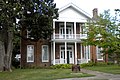
Curtis House in Metropolis, listed in the NRHP since 1978


Demographic data
As of the 2010 census , Massac County had 15,429 people in 6,518 households. The population density was 24.9 inhabitants per square kilometer. Statistically, 2.27 people lived in each of the 6,518 households.
The racial the population was composed of 91.0 percent white, 5.9 percent African American, 0.4 percent Native American, 0.3 percent Asian and other ethnic groups; 2.0 percent were descended from two or more races. Hispanic or Latino of any race was 1.9 percent of the population.
22.8 percent of the population were under 18 years old, 58.8 percent were between 18 and 64 and 18.4 percent were 65 years or older. 52.2 percent of the population was female.
The median income for a household was 38,302 USD . The per capita income was $ 20,186. 16.4 percent of the population lived below the poverty line.
Localities in Massac County
structure
Massac County is divided into 17 precincts :
| district | Population (2010) | FIPS |
|---|---|---|
| Adkins precinct | 1337 | 17-90018 |
| Benton precinct | 499 | 17-90396 |
| East Brooklyn precinct | 1241 | 17-91026 |
| Franklin precinct | 1029 | 17-91260 |
| Georges Creek precinct | 322 | 17-91332 |
| Grant precinct | 1681 | 17-91494 |
| Hillerman precinct | 892 | 17-91638 |
| Jackson precinct | 778 | 17-91692 |
| Jefferson precinct | 1692 | 17-91740 |
| Lincoln precinct | 809 | 17-91908 |
| Logan precinct | 351 | 17-91944 |
| Metropolis No. 1 precinct | 704 | 17-92070 |
| Metropolis No. 2 precinct | 492 | 17-92088 |
| Metropolis No. 3 precinct | 794 | 17-92106 |
| Metropolis No. 4 precinct | 912 | 17-92124 |
| Washington precinct | 989 | 17-93618 |
| West Brooklyn precinct | 907 | 17-93672 |
See also
Individual evidence
- ↑ GNIS-ID: 1784730. Retrieved on February 22, 2011 (English).
- ↑ a b c U.S. Census Bureau, State & County QuickFacts - Massac County, IL ( Memento of the original from July 14, 2011 on WebCite ) Info: The archive link was automatically inserted and has not yet been checked. Please check the original and archive link according to the instructions and then remove this notice. Retrieved December 20, 2012
- ^ A b National Association of Counties.Retrieved December 20, 2012
- ^ US Census Bureau - Census of Population and Housing.Retrieved March 15, 2011
- ^ Extract from Census.gov.Retrieved February 15, 2011
- ↑ Extract from the National Register of Historic Places - No. 71000293. Retrieved November 20, 2011
- ↑ Extract from the National Register of Historic Places - No. 78001172.Retrieved November 20, 2011
- ↑ Missouri Census Data Center - Illinois ( page no longer available , search in web archives ) Info: The link was automatically marked as defective. Please check the link according to the instructions and then remove this notice. Retrieved August 2, 2012
Web links
List of counties in Illinois
Adams |
Alexander |
Bond |
Boone |
Brown |
Bureau |
Calhoun |
Carroll |
Cass |
Champaign |
Christian |
Clark |
Clay |
Clinton |
Coles |
Cook |
Crawford |
Cumberland |
DeKalb |
DeWitt |
Douglas |
DuPage |
Edgar |
Edwards |
Effingham |
Fayette |
Ford |
Franklin |
Fulton |
Gallatin |
Greene |
Grundy |
Hamilton |
Hancock |
Hardin |
Henderson |
Henry |
Iroquois |
Jackson |
Jasper |
Jefferson |
Jersey |
Jo Daviess |
Johnson |
Kane |
Kankakee |
Kendall |
Knox |
LaSalle |
Lake |
Lawrence |
Lee |
Livingston |
Logan |
Macon |
Macoupin |
Madison |
Marion |
Marshall |
Mason |
Massac |
McDonough |
McHenry |
McLean |
Menard |
Mercer |
Monroe |
Montgomery |
Morgan |
Moultrie |
Ogle |
Peoria |
Perry |
Piatt |
Pike |
Pope |
Pulaski |
Putnam |
Randolph |
Richland |
Rock Island |
Saline |
Sangamon |
Schuyler |
Scott |
Shelby |
St. Clair |
Strong |
Stephenson |
Tazewell |
Union |
Vermilion |
Wabash |
Warren |
Washington |
Wayne |
White |
Whiteside |
Will |
Williamson |
Winnebago |
Woodford
Coordinates: 37 ° 13 ′ N , 88 ° 43 ′ W