
Shelby County (Illinois)
 Shelby County Courthouse |
|
| administration | |
|---|---|
| US state : | Illinois |
| Administrative headquarters : | Shelbyville |
| Address of the administrative headquarters: |
Shelby County Courthouse 301 E. Main Street P.O. Box 416 Shelbyville, IL 62565 |
| Foundation : | January 23, 1827 |
| Made up from: | Fayette County |
| Area code : | 001 217 |
| Demographics | |
| Residents : | 22,363 (2010) |
| Population density : | 11.4 inhabitants / km 2 |
| geography | |
| Total area : | 1989 km² |
| Water surface : | 25 km² |
| map | |
 |
|
| Website : shelbycounty-il.com | |
The Shelby County is a county in the US -amerikanischen State Illinois . In 2010 the county had 22,363 residents and a population density of 11.4 people per square kilometer. The county seat is Shelbyville .
geography

The county is located southeast of the geographic center of Illinois. It has an area of 1989 square kilometers, of which 25 square kilometers are water.
The Shelby County is traversed by the Kaskaskia River , which is dammed in the north to Lake Shelbyville .
The following neighboring counties border Shelby County:
| Macon County | Moultrie County | |
|
Christian County Montgomery County |
.svg)
|
Coles County Cumberland County |
| Fayette County Effingham County |
economy
The extraction of the existing mineral resources and especially the extraction of coal form the largest part of the jobs. Shelby County has 110 coal mines, most of them underground, owned by 48 different owners and employing around 2,500 people. The supplier and service companies also located in the area provide another 500 jobs.
history

| Population development | |||
|---|---|---|---|
| Census | Residents | ± in% | |
| 1830 | 2972 | - | |
| 1840 | 6650 | 123.8% | |
| 1850 | 7807 | 17.4% | |
| 1860 | 14,613 | 87.2% | |
| 1870 | 25,470 | 74.3% | |
| 1880 | 30,270 | 18.8% | |
| 1890 | 31.191 | 3% | |
| 1900 | 32,126 | 3% | |
| 1910 | 31,693 | -1.3% | |
| 1920 | 29,601 | -6.6% | |
| 1930 | 25,471 | -14% | |
| 1940 | 26,290 | 3.2% | |
| 1950 | 24,434 | -7.1% | |
| 1960 | 23,404 | -4.2% | |
| 1970 | 22,589 | -3.5% | |
| 1980 | 23,923 | 5.9% | |
| 1990 | 22,261 | -6.9% | |
| 2000 | 22,893 | 2.8% | |
| 2010 | 22,363 | -2.3% | |
| Before 1900 1900–1990 2000 2010 | |||
The Shelby County was formed on January 23, 1827 from the Fayette County. It was named after Isaac Shelby (1750-1826), an officer in the Continental Army in the American Revolutionary War and governor of Kentucky (1792-1796, 1812-1816).
Territorial development
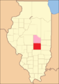
The Shelby County from its inception in 1827 to 1829
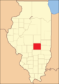
1829 to 1839
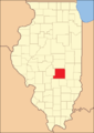
1839 to 1843

1843 until today


Demographic data
According to the 2010 census , Shelby County had 22,363 people in 8,968 households. The population density was 11.4 inhabitants per square kilometer. Statistically, 2.46 persons lived in each of the 8968 households.
The racial the population was composed of 98.5 percent white, 0.5 percent African American, 0.2 percent Native American, 0.3 percent Asian and other ethnic groups; 0.6 percent were descended from two or more races. Hispanic or Latino of any race was 1.0 percent of the population.
22.1 percent of the population were under 18 years old, 58.9 percent were between 18 and 64 and 19.0 percent were 65 years or older. 50.3 percent of the population was female.
The median income for a household was 44,689 USD . The per capita income was $ 22,522. 10.5 percent of the population lived below the poverty line.
Shelby County localities
Other Unincorporated Communities
1 - partially in Christian County
structure
Shelby County is divided into 24 townships :
|
|
See also
Web links
Individual evidence
- ↑ GNIS-ID: 1785051. Retrieved on February 22, 2011 (English).
- ↑ a b c U.S. Census Bureau, State & County QuickFacts - Shelby County, IL Retrieved January 10, 2013
- ↑ a b National Association of Counties. Retrieved January 10, 2013
- ^ US Census Bureau - Census of Population and Housing.Retrieved March 15, 2011
- ^ Extract from Census.gov.Retrieved February 15, 2011
- ↑ Missouri Census Data Center - Illinois ( page no longer available , search in web archives ) Info: The link was automatically marked as defective. Please check the link according to the instructions and then remove this notice. Retrieved January 10, 2013
List of counties in Illinois
Adams |
Alexander |
Bond |
Boone |
Brown |
Bureau |
Calhoun |
Carroll |
Cass |
Champaign |
Christian |
Clark |
Clay |
Clinton |
Coles |
Cook |
Crawford |
Cumberland |
DeKalb |
DeWitt |
Douglas |
DuPage |
Edgar |
Edwards |
Effingham |
Fayette |
Ford |
Franklin |
Fulton |
Gallatin |
Greene |
Grundy |
Hamilton |
Hancock |
Hardin |
Henderson |
Henry |
Iroquois |
Jackson |
Jasper |
Jefferson |
Jersey |
Jo Daviess |
Johnson |
Kane |
Kankakee |
Kendall |
Knox |
LaSalle |
Lake |
Lawrence |
Lee |
Livingston |
Logan |
Macon |
Macoupin |
Madison |
Marion |
Marshall |
Mason |
Massac |
McDonough |
McHenry |
McLean |
Menard |
Mercer |
Monroe |
Montgomery |
Morgan |
Moultrie |
Ogle |
Peoria |
Perry |
Piatt |
Pike |
Pope |
Pulaski |
Putnam |
Randolph |
Richland |
Rock Island |
Saline |
Sangamon |
Schuyler |
Scott |
Shelby |
St. Clair |
Strong |
Stephenson |
Tazewell |
Union |
Vermilion |
Wabash |
Warren |
Washington |
Wayne |
White |
Whiteside |
Will |
Williamson |
Winnebago |
Woodford
Coordinates: 39 ° 23 ′ N , 88 ° 49 ′ W