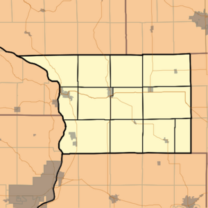
Carroll County, Illinois
![Carroll County Courthouse in Mount Carroll, listed on NRHP No. 73000692 [1]](https://upload.wikimedia.org/wikipedia/commons/thumb/1/1d/Mount_Carroll_courthouse.jpg/298px-Mount_Carroll_courthouse.jpg) Carroll County Courthouse in Mount Carroll, listed on NRHP No. 73000692 |
|
| administration | |
|---|---|
| US state : | Illinois |
| Administrative headquarters : | Mount Carroll |
| Address of the administrative headquarters: |
County Board Chairman 635 S. Clay Street Mt. Carroll, IL 61053 |
| Foundation : | 1839 |
| Area code : | 001 815 |
| Demographics | |
| Residents : | 15,387 (2010) |
| Population density : | 13.4 inhabitants / km 2 |
| geography | |
| Total area : | 1206 km² |
| Water surface : | 56 km² |
| map | |
| Website : www.gocarrollcounty.com | |
The Carroll County is a county in the US -amerikanischen State Illinois . In 2010 , the county had 15,387 residents and a population density of 13.4 people per square kilometer. The county seat is Mount Carroll .
geography
The county is located in northwest Illinois and has an area of 1,206 square kilometers, of which 56 square kilometers are water. The western county border is also the border with the state of Iowa and is of course determined by the Mississippi River . The following neighboring counties border Carroll County:
| Jo Daviess County | Stephenson County | |
|
Jackson County, Iowa |

|
Ogle County |
|
Clinton County, Iowa |
Whiteside County |
history
Carroll County was formed in 1838 from former parts of Jo Davies County. It was named after Charles Carroll (1737-1832), a large landowner and politician from Maryland and the only Catholic signatory of the US Declaration of Independence .
The decision to name the county after him was made by Issac Chambers, the first settler in the area. The real settlement only began after Emmert, Halderman & Co. built the first sawmill in the Mount Carroll area and thus created jobs. The felled wood was transported over the adjacent Mississippi. After the company had built the first wooden huts for its employees, the first public buildings were built in 1844. In the same year Joe Miles, the first lawyer, came to the area and opened a trading post and the first post office. In 1869 the first regular school with 5 classrooms and 5 teachers was put into operation.
Demographic data
| Population development | |||
|---|---|---|---|
| Census | Residents | ± in% | |
| 1840 | 1023 | - | |
| 1850 | 4586 | 348.3% | |
| 1860 | 11,733 | 155.8% | |
| 1870 | 16,705 | 42.4% | |
| 1880 | 16,976 | 1.6% | |
| 1890 | 18,320 | 7.9% | |
| 1900 | 18,963 | 3.5% | |
| 1910 | 18,035 | -4.9% | |
| 1920 | 19,345 | 7.3% | |
| 1930 | 18,433 | -4.7% | |
| 1940 | 17,987 | -2.4% | |
| 1950 | 18,976 | 5.5% | |
| 1960 | 19,507 | 2.8% | |
| 1970 | 19,276 | -1.2% | |
| 1980 | 18,779 | -2.6% | |
| 1990 | 16.805 | -10.5% | |
| 2000 | 16,674 | -0.8% | |
| 2010 | 15,387 | -7.7% | |
| Before 1900 1900–1990 2000 2010 | |||
According to the 2010 census , Carroll County had 15,387 people in 6,969 households. The population density was 13.4 inhabitants per square kilometer. Statistically, 2.22 people lived in each of the 6,969 households.
The racial the population was composed of 96.9 percent white, 0.8 percent African American, 0.3 percent Native American, 0.3 percent Asian and other ethnic groups; 1.1 percent were descended from two or more races. Regardless of ethnicity, 2.8 percent of the population was Hispanic or Latino of any race.
20.5 percent of the population were under 18 years old, 58.3 percent were between 18 and 64 and 21.2 percent were 65 years or older. 49.9 percent of the population was female.
The median income for a household was 41,578 USD . The per capita income was $ 24,904. 13.2 percent of the population lived below the poverty line.
Places in Carroll County
structure
Carroll County is divided into twelve townships :
|
|
|
See also
Individual evidence
- ^ Extract from the National Register of Historic Places.Retrieved March 13, 2011
- ^ Carroll County ( English ) In: Geographic Names Information System . United States Geological Survey . Retrieved February 22, 2011.
- ↑ a b c U.S. Census Bureau, State & County QuickFacts - Carroll County, IL Retrieved November 21, 2012
- ^ A b National Association of Counties.Retrieved November 21, 2012
- ^ US Census Bureau - Census of Population and Housing.Retrieved March 15, 2011
- ↑ Extract from Census.gov.Retrieved on February 14, 2011
- ↑ Missouri Census Data Center - Illinois ( page no longer available , search in web archives ) Info: The link was automatically marked as defective. Please check the link according to the instructions and then remove this notice. Retrieved March 3, 2014
Web links
Coordinates: 42 ° 4 ′ N , 89 ° 55 ′ W


