
Menard County (Illinois)
.jpg) Menard County Courthouse |
|
| administration | |
|---|---|
| US state : | Illinois |
| Administrative headquarters : | Petersburg |
| Address of the administrative headquarters: |
Menard County Courthouse P.O. Box 456 Petersburg, IL 62675-0456 |
| Foundation : | February 15, 1839 |
| Area code : | 001 217 |
| Demographics | |
| Residents : | 12,705 (2010) |
| Population density : | 15.6 inhabitants / km 2 |
| geography | |
| Total area : | 817 km² |
| Water surface : | 3 km² |
| map | |
 |
|
| Website : menardcountyil.com | |
The Menard County is a county in the US -amerikanischen State Illinois . In 2010 , the county had 12,705 people and a population density of 15.6 people per square kilometer. The county seat is Petersburg .
geography
The county is west of the geographic center of Illinois and is traversed by the Sangamon River , a left tributary of the Illinois River . It has an area of 817 square kilometers, of which three square kilometers are water. The following neighboring counties border Menard County:
| Mason County | ||
| Cass County |
.svg)
|
Logan County |
| Sangamon County |
history
| Population development | |||
|---|---|---|---|
| Census | Residents | ± in% | |
| 1840 | 4431 | - | |
| 1850 | 6349 | 43.3% | |
| 1860 | 9584 | 51% | |
| 1870 | 11,735 | 22.4% | |
| 1880 | 13,024 | 11% | |
| 1890 | 13,120 | 0.7% | |
| 1900 | 14,336 | 9.3% | |
| 1910 | 12,796 | -10.7% | |
| 1920 | 11,694 | -8.6% | |
| 1930 | 10,575 | -9.6% | |
| 1940 | 10,663 | 0.8% | |
| 1950 | 9639 | -9.6% | |
| 1960 | 9248 | -4.1% | |
| 1970 | 9685 | 4.7% | |
| 1980 | 11,700 | 20.8% | |
| 1990 | 11,164 | -4.6% | |
| 2000 | 12,486 | 11.8% | |
| 2010 | 12,705 | 1.8% | |
| Before 1900 1900–1990 2000 2010 | |||
Menard County was formed on February 15, 1839. It was named after Pierre Menard (1766-1844), a French pioneer and trader with Indians, who settled in Kaskaskia and later was colonel of the territorial militia. Menard was the first lieutenant governor of Illinois from 1818 to 1822 .
Abraham Lincoln lived here in New Salem from 1831 to 1837 before moving to Springfield .
Territorial development
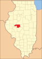
Menard County when it was founded in 1839-1841
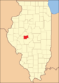
1841 until today


Demographic data
According to the 2010 census , Menard County had 12,705 people in 4,959 households. The population density was 15.6 inhabitants per square kilometer. Statistically, 2.53 people lived in each of the 4959 households.
The racial the population was composed of 97.6 percent white, 0.9 percent African American, 0.3 percent Native American, 0.3 percent Asian and other ethnic groups; 1.0 percent were descended from two or more races. Hispanic or Latino of any race was 1.1 percent of the population.
22.8 percent of the population were under 18 years old, 61.3 percent were between 18 and 64 and 15.9 percent were 65 years or older. 51.3 percent of the population was female.
The median income for a household was 56,943 USD . The per capita income was $ 26,300. 7.9 percent of the population lived below the poverty line.
Menard County localities
1 - partially in Logan County
structure
Menard County is divided into 16 precincts :
|
|
See also
Individual evidence
- ↑ GNIS-ID: 424266. Retrieved on February 22, 2011 (English).
- ↑ a b c U.S. Census Bureau, State & County QuickFacts - Menard County, IL ( Memento of the original from July 14, 2011 on WebCite ) Info: The archive link was automatically inserted and has not yet been checked. Please check the original and archive link according to the instructions and then remove this notice. Retrieved December 23, 2012
- ^ A b National Association of Counties.Retrieved December 23, 2012
- ^ US Census Bureau - Census of Population and Housing.Retrieved March 15, 2011
- ^ Extract from Census.gov.Retrieved February 15, 2011
- ↑ Missouri Census Data Center - Illinois ( page no longer available , search in web archives ) Info: The link was automatically marked as defective. Please check the link according to the instructions and then remove this notice. Retrieved December 23, 2012
Web links
List of counties in Illinois
Adams |
Alexander |
Bond |
Boone |
Brown |
Bureau |
Calhoun |
Carroll |
Cass |
Champaign |
Christian |
Clark |
Clay |
Clinton |
Coles |
Cook |
Crawford |
Cumberland |
DeKalb |
DeWitt |
Douglas |
DuPage |
Edgar |
Edwards |
Effingham |
Fayette |
Ford |
Franklin |
Fulton |
Gallatin |
Greene |
Grundy |
Hamilton |
Hancock |
Hardin |
Henderson |
Henry |
Iroquois |
Jackson |
Jasper |
Jefferson |
Jersey |
Jo Daviess |
Johnson |
Kane |
Kankakee |
Kendall |
Knox |
LaSalle |
Lake |
Lawrence |
Lee |
Livingston |
Logan |
Macon |
Macoupin |
Madison |
Marion |
Marshall |
Mason |
Massac |
McDonough |
McHenry |
McLean |
Menard |
Mercer |
Monroe |
Montgomery |
Morgan |
Moultrie |
Ogle |
Peoria |
Perry |
Piatt |
Pike |
Pope |
Pulaski |
Putnam |
Randolph |
Richland |
Rock Island |
Saline |
Sangamon |
Schuyler |
Scott |
Shelby |
St. Clair |
Strong |
Stephenson |
Tazewell |
Union |
Vermilion |
Wabash |
Warren |
Washington |
Wayne |
White |
Whiteside |
Will |
Williamson |
Winnebago |
Woodford
Coordinates: 40 ° 2 ′ N , 89 ° 48 ′ W